25th Annual Black Diamond Fall Fundraising Party
Thursday, September 13; 6:00-10:00 PM; Black Diamond Parking Lot
25th Annual Black Diamond Fall Fundraising Party
Thursday, September 13; 6:00-10:00 PM; Black Diamond Parking Lot
| Advisory: Moab Area Mountains | Issued by Eric Trenbeath for Monday - November 28, 2016 - 6:51am |
|---|

|
bottom line The avalanche danger remains CONSIDERABLE today on slopes that have recent deposits of wind drifted snow. The danger will be most pronounced on steep, wind exposed, upper elevation terrain, on slopes that have a northerly aspect, and these areas are best avoided today. The snowpack is also still quite shallow, and taking a ride in even a small avalanche would be a bumpy, nasty experience over rocks that could easily ruin the rest of the season.
|
 |
special announcement Grand County does not plan to plow the road today, and will instead be waiting for the next system to move through. I'll be meeting with them tomorrow to finalize operating procedure for the upcoming season. Today, expect to find the road snow covered with 2" near the Loop Road, and up to 6" at the Geyser Pass Trailhead. Many vehicles made it up yesterday but 4wd is required. |
 |
current conditions We're seeing fairly wide variability this morning in storm snow totals with the Geyser Pass Trailhead Snotel site reporting 6" of new at .60" of water, and the Gold Basin study plot reporting a whopping 16". I'll be going up today to verify these amounts, but reports from yesterday at least confirm that lots of fresh snow was found, and that the base is growing to the point of being rideable at 24-30". Check out this observation from Travis Nauman. But keep in mind that it's early season, and that as nicely as things are stacking up, there are still plenty of obstacles lurking beneath the surface. Strong winds blew most of the storm, first from the southwest and then shifting to westerly averaging 20-30 mph with gusts into the 40's. This morning they have backed off significantly and are averaging less than 10 mph from the northwest. It's currently a frigid 7 degrees on Pre Laurel Peak, and 16 at the Geyser Pass Trailhead. Storm totals in Gold Basin.(10,000') Wind, temperature and humidity on Pre Laurel Peak.(11,700') Snow totals, temperature and snow/water equivalent at the Geyser Pass Trailhead.(9600') |
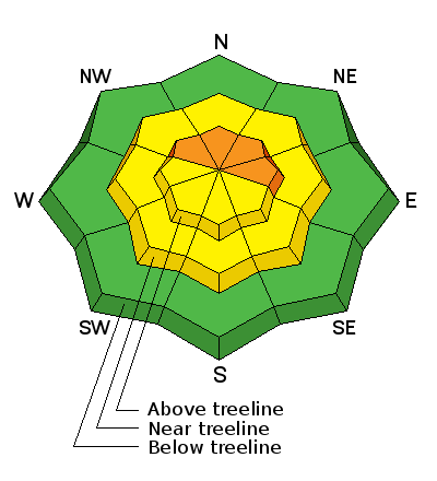
| type | aspect/elevation | characteristics |
|---|

|

|
LIKELIHOOD
 LIKELY
UNLIKELY
SIZE
 LARGE
SMALL
TREND
 INCREASING DANGER
SAME
DECREASING DANGER
|
|
description
Wind slabs formed during the storm will be more stubborn today but it's not time to write them off yet. In addition, there is plenty of loose snow out there available for transport, and there is a little more snow and wind in the forecast. Avoid steep slopes that have recent deposits of wind drifted snow and look for characteristic signs such as smooth, rounded pillows, and collapsing or cracking in the snow surface. Areas right around and above tree line, and on slopes that have a northerly aspect are the most suspect, and the potential for human triggered avalanches remains likely in these areas. |
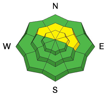
| type | aspect/elevation | characteristics |
|---|

|
|
LIKELIHOOD
 LIKELY
UNLIKELY
SIZE
LARGE
SMALL
TREND
INCREASING DANGER
SAME
DECREASING DANGER
|
|
description
The snowpack has received a significant amount of new snow over the past two days and in some areas this may equate to enough of a load to affect buried weak layers. Areas where you are most likely to encounter a persistent slab problem are on steep, northerly facing aspects at mid to upper elevations. Digging a snowpit, and performing a stability test is the only way to ascertain whether or not this problem exists, and this practice is highly recommended before venturing on to steep, avalanche prone terrain. |
 |
weather Today Snow showers. Widespread blowing snow, mainly after 4pm. High near 17. Breezy, with a west southwest wind 10 to 15 mph increasing to 15 to 20 mph in the afternoon. Chance of precipitation is 80%. Total daytime snow accumulation of 1 to 3 inches possible. Tonight Snow showers likely, mainly before 2am. Cloudy, with a low around 8. Wind chill values as low as -10. Blustery, with a west northwest wind 20 to 25 mph decreasing to 10 to 15 mph after midnight. Winds could gust as high as 35 mph. Chance of precipitation is 70%. New snow accumulation of 3 to 5 inches possible. Tuesday A 50 percent chance of snow. Partly sunny, with a high near 16. North wind around 15 mph. New snow accumulation of less than one inch possible. Tuesday Night A 10 percent chance of snow before 11pm. Partly cloudy, with a low around 7. North northwest wind around 10 mph. Wednesday Sunny, with a high near 19. West northwest wind around 10 mph. Wednesday Night Partly cloudy, with a low around 11. Thursday A 10 percent chance of snow. Mostly sunny, with a high near 18. Thursday Night A chance of snow, mainly after 11pm. Mostly cloudy, with a low around 10. Friday A slight chance of snow. Partly sunny, with a high near 17. |


