| Please join us at the 23rd annual Black Diamond Fall Fundraiser Party Thursday Sept 15. Tickets are on sale now here, at the Black Diamond store & at REI. Special bonus raffle for online ticket purchasers! |
| Please join us at the 23rd annual Black Diamond Fall Fundraiser Party Thursday Sept 15. Tickets are on sale now here, at the Black Diamond store & at REI. Special bonus raffle for online ticket purchasers! |
| Advisory: Moab Area Mountains | Issued by Eric Trenbeath for Saturday - April 2, 2016 - 6:49am |
|---|


|
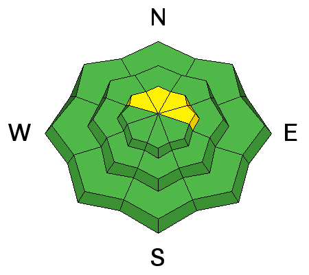
bottom line Today the avalanche danger remains MODERATE in areas where you can detect deposits of wind drifted snow. The danger is most pronounced on upper elevation slopes that have a N-NE-E aspect. Suspect slopes with steep convexities, and areas of more extreme, rocky and radical terrain. And as the strong warm sun hits the snow surface today, the danger for wet slide activity will rise to MODERATE on steep, sun exposed slopes. Look for signs of instability such as roller balls, pinwheels, and sloppy wet snow. Stay off of and out from under steep slopes when these signs are present. .
|
 |
current conditions Skies are clear, northerly winds are light, and temps are in the low 20's at 10,000'. Reed Kennard was out and about yesterday and reported the full gammut of spring conditions from good settled powder on upper elevation, shady aspects, to sun crusts, and wet, gloppy snow. Read about his travels here.
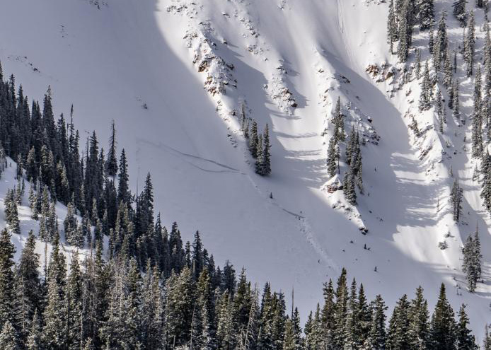
Recreation, Wilderness and Trails Program Manager Brian Murdock sent in this pic from his travels yesterday. It shows lots of snow on the high peaks as well as a good perspective on the Exxon's slide from earlier in the week. Winds, temperature and humidity on Pre-Laurel Peak New snow totals, temperature and humidity in Gold Basin Total snow depth and temperature at Geyser Pass Trailhead
|
 |
recent activity Several natural avalanches occurred within the new snow during the height of the storm on Tuesday including this one observed by Ryan Schantzenbach in Exxon's Folley. You can read his description here.
|
| type | aspect/elevation | characteristics |
|---|

|
|
LIKELIHOOD
 LIKELY
UNLIKELY
SIZE
 LARGE
SMALL
TREND
 INCREASING DANGER
SAME
DECREASING DANGER
|
|
description
Though I suspect they have gained strength and are now fairly well bonded, you still need to be on the lookout for wind slabs that formed earlier in the week in upper elevation, wind exposed terrain. Carefully evaluate steep slopes for smooth rounded pillows of wind deposited snow. Be suspicious of convex break-overs and other terrain features in areas of steeper, more radical terrain. There may also be isolated cases where a triggered wind slab could fail on deeper, faceted snow in perhaps a repeat running slide path, or where the underlying snow pack is shallow and weak. |
| type | aspect/elevation | characteristics |
|---|

|

|
LIKELIHOOD
LIKELY
UNLIKELY
SIZE
 LARGE
SMALL
TREND
 INCREASING DANGER
SAME
DECREASING DANGER
|
|
description
The sun and clouds have been playing cat and mouse over the last several days keeping wet slide activity down to a minimum. Today will be a different story however, with sunny skies and temperatures rising into the mid 40's around 10,000'. Be alert to signs of rising instability such as roller balls, pinwheels, and sloppy wet snow. Stay off of, and out from under steep, sun exposed slopes when these signs are present. Though the danger will be most pronounced on slopes that face E-S-W, northerly facing aspects aren't immune this time of year, particularly at the lower elevations. |
 |
weather Today Sunny, with a high near 43. Northeast wind 5 to 10 mph becoming west southwest in the afternoon. Tonight Mostly clear, with a low around 28. West southwest wind 5 to 10 mph. Sunday Sunny, with a high near 48. Northwest wind 5 to 10 mph. Sunday Night Mostly clear, with a low around 32. Northwest wind 5 to 10 mph becoming southwest after midnight. Monday Mostly sunny, with a high near 51. Southwest wind 5 to 15 mph. |
| general announcements Road Conditions: The road is plowed down to the dirt and will get muddy in the afternoon. Grooming Conditons: The road into Gold Basin has been packed out with roller and is suitable for cross country skiing. It's quite rough for skating. To post an observation go here. You can view Moab observations here. You can also give me a call on my cell phone at 801-647-8896 To receive this advisory by email go here. This information does not apply to developed ski areas or highways where avalanche control is normally done. This advisory is from the U.S.D.A. Forest Service, which is solely responsible for its content. This advisory describes general avalanche conditions and local variations always exist. |