| Please join us at the 23rd annual Black Diamond Fall Fundraiser Party Thursday Sept 15. Tickets are on sale now here, at the Black Diamond store & at REI. Special bonus raffle for online ticket purchasers! |  |

| Please join us at the 23rd annual Black Diamond Fall Fundraiser Party Thursday Sept 15. Tickets are on sale now here, at the Black Diamond store & at REI. Special bonus raffle for online ticket purchasers! |  |
| Advisory: Moab Area Mountains | Issued by Eric Trenbeath for Saturday - March 26, 2016 - 7:22am |
|---|
 |
current conditions It's a gray morning and mid level clouds are hanging over the mountains. NW winds on Pre Laurel Peak are averaging in the teens, but they bumped up in into the mid 20's with gusts to 40 for a few hours around midnight. Temps are wintery this morning, in the mid teens at 10,000'. Powder snow can still be found in sheltered areas, but a variety of hard surfaces still exist underneath the most recent snow. Winds, temperature and humidity on Pre-Laurel Peak New snow totals, temperature and humidity in Gold Basin Total snow depth and temperature at Geyser Pass Trailhead
|
 |
recent activity
The new snow and wind from the Tue-Wed storm filled in this repeat running slide path just enough for these two unknown folks to pull it out again yesterday. This is the same pocket that was triggered a couple of weeks ago that resulted in a serious injury. Note the areas of wind drifted snow, and the very steep, convex, and rocky nature of the terrain where the slab released. It looks like a wind slab that stepped down into weak, sugary, faceted snow. This is a NE facing slope at around 11,000'.
|
| type | aspect/elevation | characteristics |
|---|


|


|

LIKELIHOOD
 LIKELY
UNLIKELY
SIZE
 LARGE
SMALL
TREND
 INCREASING DANGER
SAME
DECREASING DANGER
|
|
description
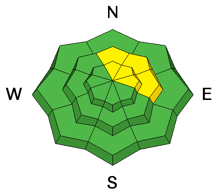
Winds have continued to move the loose snow around in the high country, and you need to remain on the lookout for wind slabs on the lee sides of upper elevation ridge crests and terrain features. Look for signs of instability such as cracking in the snow surface, and avoid steep slopes with smooth, rounded deposits of wind drifted snow. |
| type | aspect/elevation | characteristics |
|---|


|


|

LIKELIHOOD
 LIKELY
UNLIKELY
SIZE
 LARGE
SMALL
TREND
 INCREASING DANGER
SAME
DECREASING DANGER
|
|
description
Though more the exception than the rule, Thursday's human triggered avalanche demonstrates that triggered wind slabs still have the potential to step down into sugary, faceted snow in areas where the snowpack is shallow and weak. Repeat running slide paths are especially suspect, as are areas of steep and rocky, more radical terrain that has a N-NE-E aspect. |
 |
weather A low pressure system moving through the region looks to be zeroed in on the southern San Juan Mountains. The La Sals will see a chance for snow showers this morning with partly sunny skies developing by afternoon. NW winds will be on the increase into the 15-20 mph range with gusts to 30, and high temps at 10,000' will be in the mid to high 20's. Sunday looks to be mostly sunny. Clouds return on Monday ahead of the next approaching system. Today Snow showers likely, mainly before noon. Areas of blowing snow after 8am. Partly sunny, with a high near 27. Blustery, with a north wind 15 to 20 mph, with gusts as high as 30 mph. Chance of precipitation is 70%. Total daytime snow accumulation of 1 to 3 inches possible. Tonight A 20 percent chance of snow before 8pm. Areas of blowing snow before 8pm. Partly cloudy, with a low around 15. Blustery, with a north wind 15 to 20 mph becoming south in the evening. Sunday Mostly sunny, with a high near 37. Southwest wind around 15 mph, with gusts as high as 25 mph. Sunday Night Partly cloudy, with a low around 24. Windy, with a south southwest wind 15 to 20 mph increasing to 25 to 30 mph after midnight. Winds could gust as high as 40 mph. Monday A 20 percent chance of snow after noon. Areas of blowing snow after noon. Partly sunny, with a high near 43. Windy, with a south southwest wind 30 to 35 mph, with gusts as high as 50 mph. |
| general announcements To post an observation go here. You can view Moab observations here. You can also give me a call on my cell phone at 801-647-8896 To receive this advisory by email go here. This information does not apply to developed ski areas or highways where avalanche control is normally done. This advisory is from the U.S.D.A. Forest Service, which is solely responsible for its content. This advisory describes general avalanche conditions and local variations always exist. |
Advisory Hotline: (888) 999-4019 | Contact Information