| Please join us at the 23rd annual Black Diamond Fall Fundraiser Party Thursday Sept 15. Tickets are on sale now here, at the Black Diamond store & at REI. Special bonus raffle for online ticket purchasers! |
| Please join us at the 23rd annual Black Diamond Fall Fundraiser Party Thursday Sept 15. Tickets are on sale now here, at the Black Diamond store & at REI. Special bonus raffle for online ticket purchasers! |
| Advisory: Moab Area Mountains | Issued by Eric Trenbeath for Tuesday - March 8, 2016 - 6:55am |
|---|

|
bottom line 6-10" of new snow and moderate southwesterly winds from the Monday-Tuesday storm has created a MODERATE avalanche danger for recently deposited wind slabs on the lee sides of ridge crests and terrain features in upper elevation, wind exposed terrain, primarily on slopes with a NW-N-E aspect. Look for signs of instability such as cracking in the snow surface, and characteristic smooth rounded pillows of freshly drifted snow.
|
 |
special announcement Check out the Banff Mountain Film Festival at Grand County High School tonight, March 7, and Tuesday, March 8 at 7:00 p.m. Buy tickets for $10 in advance at Back of Beyond Bookstore, 83. N. Main St., Canyon Voyages Adventure Co., 211 N. Main St., Pagan Mountaineering, 59 S. Main St., and Poison Spider Bicycles, 497 N. Main St.or $15 at the door. Procedes benefit the Utah Avalanche Center Moab, and Second Chance Wildlife Rehabilitaiton.
|
 |
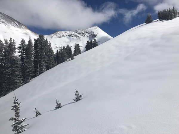
current conditions Skies are clear, temperatures are cold, and 6-10" of new snow grace the mountains from the Monday night - Tuesday morning storm. Northeast winds overnight have been light but have picked up into the 15-20 mph range as of 5:00 a.m. I took a tour yesterday up along Pre Laurel ridge and down into Gold Basin, and conditions are vastly improved with great riding and turning below tree line, and on sheltered, upper elevation, north facing terrain. Above treeline winds during the storm managed to do some sculpting, primarily on south and west facing aspects and along exposed ridgecrests. Needless to say, it will be a great day to get out in the mountains with the only drawback being the strong March sun. It only came out for a few hours yesterday, but it was long enough to moisten exposed aspects and these slopes will have developed a thin crust overnight. Base depth in Gold Basin: 69" Winds, temperature and humidity on Pre-Laurel Peak New snow totals, temperature and humidity in Gold Basin Total snow depth and temperature at Geyser Pass Trailhead
A new coat off snow has improved things greatly and good powder exists just below treeline or on more sheltered slopes above.
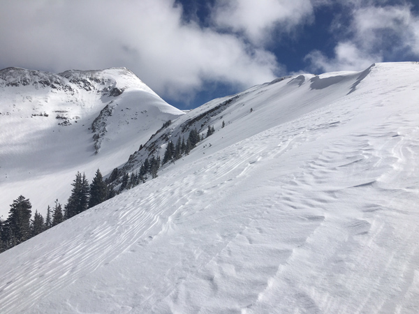
But go a little higher into more exposed terrain and it starts to look like this. |
 |
recent activity During the height of the storm on Monday night, numerous loose sluffs ran on N-E aspects in extreme, upper elevation terrain, on slopes greater than 40 degrees. In my travels yesterday, I did not observe any natural slab avalanche activity.
|
| type | aspect/elevation | characteristics |
|---|

|

|
LIKELIHOOD
 LIKELY
UNLIKELY
SIZE
 LARGE
SMALL
TREND
 INCREASING DANGER
SAME
DECREASING DANGER
|
|
description
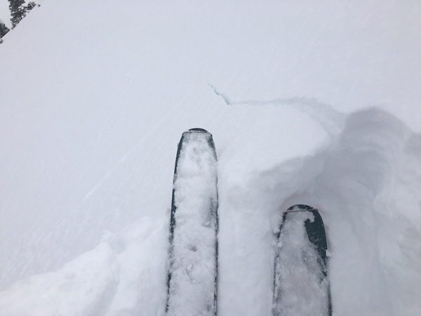
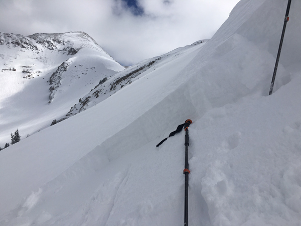
In my travels yesterday I observed some cracking and was able to pry out some recent wind drifts along upper elevation, leeward ridge crests. They weren't very reactive, and I expect them to gain even more strength over the next day or so. Nevertheless, you need to be suspicious of recent deposits of wind drifted snow, especially in upper elevation, steep and committing terrain, primarily on slopes with a NW-N-E aspect. Look for signs of instability such as cracking in the snow surface, and when you can do so safely, test suspicious looking drifts with a slope cut.
Drifts along ridge crests were cracking but not propagating very well.
I was able to pry out this drift that was up to 18" deep but quickly tapered down to about 4" It did not propagate and was only a few feet wide.
|
 |
weather Today Mostly sunny, with a high near 27. North wind 10 to 15 mph. Tonight Partly cloudy, with a low around 19. North northwest wind 10 to 15 mph. Wednesday Mostly sunny, with a high near 29. Northwest wind 10 to 15 mph. Wednesday Night Mostly clear, with a low around 22. North northwest wind 10 to 15 mph. Thursday Sunny, with a high near 39. North wind 10 to 15 mph. Thursday Night Mostly clear, with a low around 26. Friday Sunny, with a high near 40. |
| general announcements Road Conditions: Up to 5" of new snow fell on the Geyser Pass Road and it has not been plowed. Numerous vehicles made it up yesterday and it is passable for vehicles with 4wd. The lower portions will be very sloppy by afternoon. Grooming: Trails will be groomed today. To post an observation go here. You can view Moab observations here. You can also give me a call on my cell phone at 801-647-8896 To receive this advisory by email go here. This information does not apply to developed ski areas or highways where avalanche control is normally done. This advisory is from the U.S.D.A. Forest Service, which is solely responsible for its content. This advisory describes general avalanche conditions and local variations always exist. |