| Please join us at the 23rd annual Black Diamond Fall Fundraiser Party Thursday Sept 15. Tickets are on sale now here, at the Black Diamond store & at REI. Special bonus raffle for online ticket purchasers! |
| Please join us at the 23rd annual Black Diamond Fall Fundraiser Party Thursday Sept 15. Tickets are on sale now here, at the Black Diamond store & at REI. Special bonus raffle for online ticket purchasers! |
| Advisory: Moab Area Mountains | Issued by Eric Trenbeath for Sunday - March 6, 2016 - 7:34am |
|---|

|
bottom line The avalanche danger will rise to MODERATE today in upper elevation, wind exposed terrain where you can detect recent deposits of wind drifted snow. Be alert to accumulating fresh drifts on the lee sides of ridge crests and terrain features. The rate that the danger increases will be commensurate with new snow totals and will be greatest later in the day.
|
 |
special announcement
|
 |
current conditions Skies are cloudy and snow has begin to fall as a fast moving Pacific storm system moves into our area. 3-5" of new snow are possible today with another 5-9" tonight. It will be a bit wild out there today with blustery, southwest winds, snow showers, and a variety of snow surfaces under foot. Winds on Pre Laurel Peak are currently blowing in the 30-40 mph range and are expected to continue throughout the day. It's currrently 22 degrees up there, and 32 at the Geyser Pass Trailhead. Winds, temperature and humidity on Pre-Laurel Peak New snow totals, temperature and humidity in Gold Basin Total snow depth and temperature at Geyser Pass Trailhead |
 |
recent activity
|
| type | aspect/elevation | characteristics |
|---|

|
|
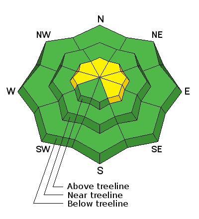
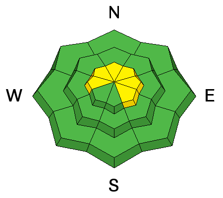
LIKELIHOOD
 LIKELY
UNLIKELY
SIZE
 LARGE
SMALL
TREND
 INCREASING DANGER
SAME
DECREASING DANGER
|
|
description
Expect a rising avalanche danger today for newly deposited wind slabs on upper elevation, leeward slopes. Wind slabs today will be mostly shallow and isolated, but will become more widespread and have greater connectivity by tomorrow as more snow accumulates. The underlying snow surface is slick and hard in many areas, so even a triggered shallow wind slab could have the potential to sweep you off your feet or carry over a rock band.
|
 |
weather A fast moving Pacific storm system on a southwest flow is spreading over our area this morning, and snow has already begun to fall. The cold front will arrive this afternoon and snowfall intensity will increase with the highest amounts coming in tonight. Snow showers will linger into Monday as the flow shifts to northwest.We could see a foot of snow out of this. Today Snow showers. Some thunder is also possible. High near 33. Windy, with a southwest wind 25 to 30 mph, with gusts as high as 45 mph. Chance of precipitation is 90%. Total daytime snow accumulation of 3 to 5 inches possible. Tonight Snow showers. Some thunder is also possible. Low around 16. Windy, with a south southwest wind 25 to 30 mph decreasing to 15 to 20 mph after midnight. Winds could gust as high as 40 mph. Chance of precipitation is 100%. New snow accumulation of 5 to 9 inches possible. Monday Snow showers. High near 26. Blustery, with a west wind 20 to 25 mph decreasing to 10 to 15 mph in the morning. Winds could gust as high as 40 mph. Chance of precipitation is 80%. New snow accumulation of 1 to 3 inches possible. Monday Night A 20 percent chance of snow before 11pm. Partly cloudy, with a low around 18. West wind 10 to 15 mph becoming east in the evening. Tuesday Mostly sunny, with a high near 29. North northeast wind around 15 mph. |
| general announcements Road Conditions: The new snow has been packed in and in some places has already melted off down to the dirt. Grooming: Trails have not been groomed recently. To post an observation go here. You can view Moab observations here. You can also give me a call on my cell phone at 801-647-8896 To receive this advisory by email go here. This information does not apply to developed ski areas or highways where avalanche control is normally done. This advisory is from the U.S.D.A. Forest Service, which is solely responsible for its content. This advisory describes general avalanche conditions and local variations always exist. |


