| Please join us at the 23rd annual Black Diamond Fall Fundraiser Party Thursday Sept 15. Tickets are on sale now here, at the Black Diamond store & at REI. Special bonus raffle for online ticket purchasers! |
| Please join us at the 23rd annual Black Diamond Fall Fundraiser Party Thursday Sept 15. Tickets are on sale now here, at the Black Diamond store & at REI. Special bonus raffle for online ticket purchasers! |
| Advisory: Moab Area Mountains | Issued by Eric Trenbeath for Friday - February 26, 2016 - 7:07am |
|---|


|
bottom line The avalanche danger is generally LOW but remember that low danger doesn't mean no danger. Continue to exercise caution in areas of steep, rocky, more radical terrain where you may still be able to trigger an isolated wind slab, or even a deeper, buried persistent slab. As the day heats up, be alert to signs of wet instability on sun exposed slopes such as roller balls, pinwheels, or sloppy wet snow. Stay off of and out from under steep slopes when these signs are present.
|
 |
special announcement
|
 |
current conditions
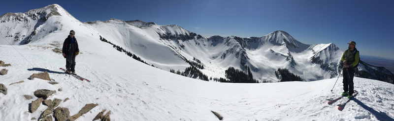
Well it may not be winter, but at least it's beautiful in the mountains. Conditions are spring like with a mix of wind and sun crusts, and some sloppy snow in the afternoon, but Monday's 6" of new snow has freshened up the scene and made for some decent dust on crust conditions on sheltered, northerly aspects. Winds are light and northerly this morning and temperatures are well below freezing. It's 25 degrees on Pre Laurel Peak, and 26 at the Geyser Pass Trailhead. Base Depth in Gold Basin: 64"
Pretty decent dust on crust conditions exist on upper elevation, northerly aspects. Lower angle slopes provide the most cushion. Winds, temperature and humidity on Pre-Laurel Peak New snow totals, temperature and humidity in Gold Basin Total snow depth and temperature at Geyser Pass Trailhead |
 |
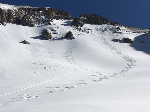
recent activity
|
| type | aspect/elevation | characteristics |
|---|

|
|
LIKELIHOOD
 LIKELY
UNLIKELY
SIZE
 LARGE
SMALL
TREND
 INCREASING DANGER
SAME
DECREASING DANGER
|
|
description
The avalanche danger is generally low right now, but low danger doesn't mean no danger and you should always maintain avalanche awareness and practice safe travel techniques in avalanche terrain. Here are a few problems to remain on the lookout for: Wind Slabs: You may still encounter isolated wind slab pockets in areas of steep, radical, wind exposed terrain. Suspect the lee sides of terrain features such as gully walls, sub ridges, or rock buttresses. Persistent / Deep Slabs: There still may be isolated pockets where a hard slab sits on top of weak, shallow, sugary snow. Suspect areas of rocky, radical terrain that has avalanched or been repeatedly scoured out through the season. Give extra caution to steep rollovers and blind break overs. Loose Wet Slides: As the day heats up be alert to signs of wet instability such as rollerballs or pinwheels, and stay off of and out form under steep slopes when these signs are present.
|
 |
weather We'll remain under dry and sunny skies for most of the weekend with maybe a brief interlude of passing clouds Saturday evening. A disorganized storm system will move into the region on Monday, but the jury is still out on that one. After that it looks like back to high pressure for most of next week. Today Sunny, with a high near 35. Northwest wind 5 to 10 mph becoming south southwest in the afternoon. Tonight Mostly clear, with a low around 27. Southwest wind 5 to 10 mph. Saturday Mostly sunny, with a high near 36. West southwest wind 10 to 15 mph. Saturday Night Partly cloudy, with a low around 23. West northwest wind 10 to 15 mph. Sunday Sunny, with a high near 32. West northwest wind 5 to 10 mph. |
| general announcements Road Conditions: The new snow has been packed in and in some places has already melted off down to the dirt. Grooming: All trails were groomed yesterday. To post an observation go here. You can view Moab observations here. You can also give me a call on my cell phone at 801-647-8896 To receive this advisory by email go here. This information does not apply to developed ski areas or highways where avalanche control is normally done. This advisory is from the U.S.D.A. Forest Service, which is solely responsible for its content. This advisory describes general avalanche conditions and local variations always exist. |