| Please join us at the 23rd annual Black Diamond Fall Fundraiser Party Thursday Sept 15. Tickets are on sale now here, at the Black Diamond store & at REI. Special bonus raffle for online ticket purchasers! |
| Please join us at the 23rd annual Black Diamond Fall Fundraiser Party Thursday Sept 15. Tickets are on sale now here, at the Black Diamond store & at REI. Special bonus raffle for online ticket purchasers! |
| Advisory: Moab Area Mountains | Issued by Eric Trenbeath for Saturday - February 13, 2016 - 6:32am |
|---|

|
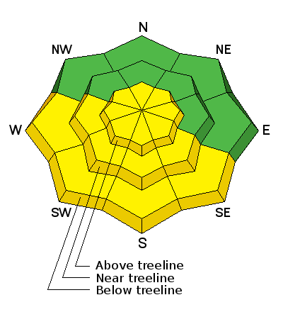
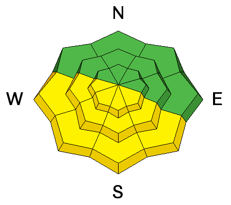
bottom line With daytime heating today the avalanche danger will rise to MODERATE on sunny aspects. If the snow starts to feel wet, sloppy, or punchy, it is time to get off of and stay out from under steep, sun exposed slopes. A very isolated or MODERATE danger for triggering a persistent slab still remains on steep, northerly facing aspects in areas of shallow snowpack, or in extreme rocky terrain. Elsewhere the avalanche danger is generally LOW.
|
 |
current conditions It's been feeling more like April in the mountains than February and I wish someone would crank down the heat! The snow surface is a pretty extreme mix of wind scour, melt freeze crusts, and heavy, wet glop. Our hunt for corn snow yesterday turned up with varying results and we found it only on smooth, well protected southerly aspects at mid elevations. Getting it early is key, as warming is occurring very rapidly. Some chalky, re-crystallized "powder" can be found on sheltered, upper elevation northerly aspects. Above about 10,000' we continue to have regular overnight freezes and it is currently 29 on Pre Laurel Peak and 31 in Gold Basin. At the Geyser Pass Trailhead (9600') however, it is a balmy 36 degrees this morning. Overnight winds have been on the increase, and they are currently averaging 20-25 mph with gusts to 30 from the southwest. Winds, temperature and humidity on Pre-Laurel Peak New snow totals, temperature and humidity in Gold Basin Total snow depth and temperature at Geyser Pass Trailhead |
 |
recent activity
|
| type | aspect/elevation | characteristics |
|---|

|
|
LIKELIHOOD
 LIKELY
UNLIKELY
SIZE
 LARGE
SMALL
TREND
 INCREASING DANGER
SAME
DECREASING DANGER
|
|
description
The frozen snow surface will quickly thaw today and you will need to be alert to a rising danger for wetslide activity. If the snow starts feeling punchy, sloppy, or you notice signs of instability such as roller balls or pinwheels, it is time to get off of and stay out from under steep slopes. |
| type | aspect/elevation | characteristics |
|---|

|

|
LIKELIHOOD
 LIKELY
UNLIKELY
SIZE
 LARGE
SMALL
TREND
 INCREASING DANGER
SAME
DECREASING DANGER
|
|
description
In general, the danger for triggering a persistent slab, or deep persistent slab is growing increasingly unlikely and north facing aspects are mostly stable. Areas where you may still encounter a problem are on steep, northerly facing aspects where the snow is shallow, or in areas of extreme rocky terrain. |
 |
weather A couple of weak disturbances to the north will bring a few clouds and increased winds to our area today. Today Increasing clouds, with a high near 49. Breezy, with a west southwest wind 15 to 20 mph becoming northwest in the afternoon. Tonight Mostly clear, with a low around 26. Northwest wind around 15 mph, with gusts as high as 30 mph. Sunday Mostly sunny, with a high near 34. Breezy, with a northwest wind 20 to 25 mph, with gusts as high as 45 mph. Sunday Night Partly cloudy, with a low around 21. Blustery, with a north northwest wind 15 to 20 mph, with gusts as high as 30 mph. Washington's Birthday Mostly sunny, with a high near 33. North northwest wind around 15 mph. |
| general announcements Road Conditions: The road is plowed but getting sloppy and muddy. Grooming: The trails were groomed Friday. This is a single-person operation and I can't be everywhere at once. You can contribute to your own, community avalanche forecast by letting me know what you're finding. You can view Moab observations here. To post an observation go here. You can also give me a call on my cell phone at 801-647-8896 To receive this advisory by email go here. This information does not apply to developed ski areas or highways where avalanche control is normally done. This advisory is from the U.S.D.A. Forest Service, which is solely responsible for its content. This advisory describes general avalanche conditions and local variations always exist. |


