| Please join us at the 23rd annual Black Diamond Fall Fundraiser Party Thursday Sept 15. Tickets are on sale now here, at the Black Diamond store & at REI. Special bonus raffle for online ticket purchasers! |
| Please join us at the 23rd annual Black Diamond Fall Fundraiser Party Thursday Sept 15. Tickets are on sale now here, at the Black Diamond store & at REI. Special bonus raffle for online ticket purchasers! |
| Advisory: Moab Area Mountains | Issued by Bruce Tremper for Monday - February 1, 2016 - 6:20am |
|---|

|
bottom line The danger will depend on the amount of new snow, and especially, on the amount of wind. So carefully test the new snow as you travel by regularly digging down with your hand to see how well it's bonded to the underlying snow and regularly jump on small, test slopes to see how they respond. The avalanche danger will range from MODERATE to HIGH depending on your choice of terrain.
|
 |
avalanche warning I am issuing an avalanche warning this morning for the La Sal and Abajo Mountains. With the expected additional snow today and the expected increased winds tonight and on Tuesday, we will likely have a high danger of avalanches, especially in the upper elevation, wind exposed terrain. |
 |
special announcement Here's an experimental, video forecast that I put together last night. Let me know what you think.
|
 |
current conditions Hello, this is Bruce Tremper, filling in for Eric Trenbeath for the next week. Well it's about time. We finally got the snow amount forecasted. Nine inches of snow fell in Gold Basin since I cleaned 4 inches off the interval board yesterday afternoon. That makes 13 inches of snow during the storm with about an inch of water weight. Similar amounts appear to have fallen in the Abajo Mountains. Temperatures are in the lower 20's. On Pre Laural Peak, the temperature is 11 degrees and the wind is blowing from the south, 30, gusting to 45. Yesterday, the Geyser Pass road was passable for 4x4 with good tires but has not been plowed for many days. With an additional 9 inches of snow overnight, with more to come today, I'm guessing it will be pretty sporty today. Base depth in gold Basin: 70" Winds, temperature and humidity on Pre-Laurel Peak New snow totals, temperature and humidity in Gold Basin Total snow depth and temperature at Geyser Pass Trailhead |
 |
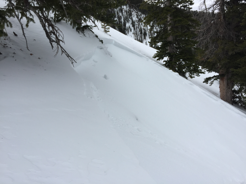
recent activity Yesterday someone found a wind slab in Gold Basin. Luckily, it was a fairly small slide and they were able to get off to the side. Here's the link to their observation: https://utahavalanchecenter.org/avalanches/26488
|
| type | aspect/elevation | characteristics |
|---|

|
|
LIKELIHOOD
 LIKELY
UNLIKELY
SIZE
 LARGE
SMALL
TREND
 INCREASING DANGER
SAME
DECREASING DANGER
|
|
description
The danger today will depend mostly on the amount of new snow, and especially, on the amount of wind. Weather forecasts are one of the most uncertain things in life, especially in rural areas, so you will need to carefully test the snow as you travel today. Be sure to regularly dig down with your hand and see how well the new snow is bonding to the underlying layers, plus regularly jump on small, test slopes to see how they respond. Especially on slopes where the wind has been blowing , you'll find denser, wind slabs that will crack with your weight. I was certainly finding some yesterday on the upper section of Laural Highway. The pre-existing snowpack is mostly deep and stable but the weakest layers are on the pre-existing snow surface. In some of the upper elevation, steep, shaded slopes, I have been finding more near-surface faceted snow just under the snow surface, especially in repeater slide paths. As the snow piles up, we should see some storm slabs sliding both on the preexisting sun crusts and on the weak, preexisting faceted snow and surface hoar on the shady aspects.
|
 |
weather The National Weather Service forecasts 7 - 11 inches of additional snow today with wind from the southwest 30, gusting to 40. Tonight, the wind should switch to the north and it should get even more blustery tonight and on Tuesday. Temperatures should be in the low 20's today, dropping into the mid to low teens tomorrow. The storm should clear out by mid day on Tuesday with nice weather for the rest of the week. Here's the National Weather Service link to the point forecast for the La Sal Mountains. |
| general announcements Road Conditions: The road has not been plowed but yesterday it was barely passable with 4x4 and good tires. With the additional 9 inches of snow overnight and additional snow forecast for today, it should be very sporty road conditions. The Forest Service is working with Grand and San Juan Counties to develop a plowing solution. Please bear with us until it can be worked out. Grooming: The tracks have not been groomed. Thanks for sending in your observations. You can view Moab observations here. To post an observation go here. To receive this advisory by email go here. This information does not apply to developed ski areas or highways where avalanche control is normally done. This advisory is from the U.S.D.A. Forest Service, which is solely responsible for its content. This advisory describes general avalanche conditions and local variations always exist. |