| Please join us at the 23rd annual Black Diamond Fall Fundraiser Party Thursday Sept 15. Tickets are on sale now here, at the Black Diamond store & at REI. Special bonus raffle for online ticket purchasers! |
| Please join us at the 23rd annual Black Diamond Fall Fundraiser Party Thursday Sept 15. Tickets are on sale now here, at the Black Diamond store & at REI. Special bonus raffle for online ticket purchasers! |
| Advisory: Moab Area Mountains | Issued by Bruce Tremper for Saturday - January 30, 2016 - 5:51am |
|---|

|
bottom line Although today, the avalanche danger is mostly LOW this morning, it should rapidly rise to CONSIDERABLE by late afternoon and overnight because of dense new snow combined with wind. Another shot of snow on Sunday night should add perhaps another foot of new snow causing the avalanche danger to rise to HIGH. Be sure to closely monitor weather forecasts and I'll continue to update this forecast through the next several days.
|
 |
avalanche watch Yesterday, I issued an Avalanche Watch for the mountains of southeastern Utah and it may turn to a Warning overnight, depending on how much snow we get. We're expecting heavy snow Saturday afternoon and night with another shot of snow on Sunday night. Total snow may add up to a couple feet. Stay tuned for this potentially major winter storm. |
 |
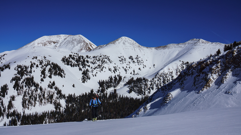
current conditions Hello, this is Bruce Tremper, filling in for Eric Trenbeath while he's away for the next 10 days. It's cloudy and very warm this morning with temperatures at Geyser Pass near freezing. The wind on Pre Laurel Peak have picked up and are blowing 25, gusting to 30 from the southwest. It has not started snowing yet but there is dense, mountains snow falling in northern Utah and it should be here later in the afternoon and evening. The Geyser Pass road is not plowed but it's packed down with vehicle traffic and it's very passable with 4x4 and good tires. Here's a link to a video I created on Thursday of the current snowpack conditions: Base depth in gold Basin: 63" Winds, temperature and humidity on Pre-Laurel Peak New snow totals, temperature and humidity in Gold Basin Total snow depth and temperature at Geyser Pass Trailhead
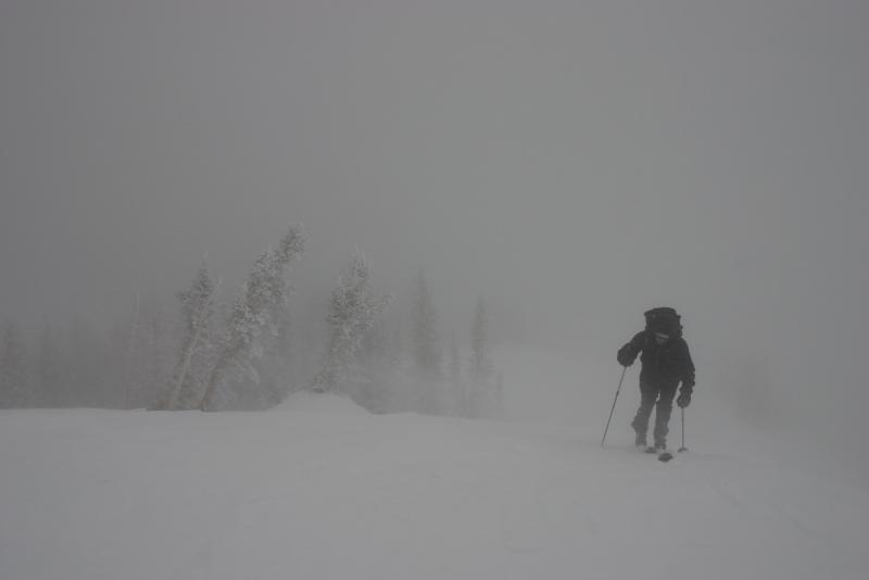
Conditions have rapidly changed from this:
To this...
|
 |
recent activity No significant avalanche activity since about Sunday when some wind slabs released after the last bit of snow and wind last weekend. For instance a significant slab released off the shoulder of Tuk-No that Eric reported on the Tuesday update.
|
| type | aspect/elevation | characteristics |
|---|

|
|
LIKELIHOOD
 LIKELY
UNLIKELY
SIZE
 LARGE
SMALL
TREND
 INCREASING DANGER
SAME
DECREASING DANGER
|
|
description
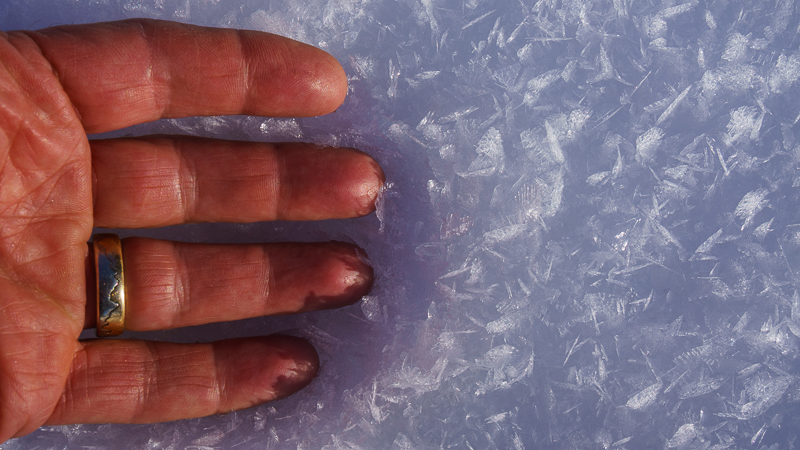
Although the avalanche danger is mostly LOW this morning (see the video I made yesterday), it should rapidly rise through the day and especially afternoon and overnight. I'm expecting about a little less than a foot of dense snow overnight and perhaps another foot of snow to fall on Sunday night. The present snow surface is very soft and weak on the shady, wind-sheltered aspects so I would expect storm slabs to fracture easily, especially on the slopes that face the north and east quadrants of the compass. Storm snow avalanches may also include wind slabs and some persistent slabs on top of pockets of surface hoar. Here's a photo from yesterday of the widespread surface hoar on all the sun and wind sheltered slopes. This will be a very slippery and persistent weak layer when it gets buried by all the new snow expected over the weekend. Hopefully, the strong wind and warm temperatures will destroy most of it before it gets buried today but you may still find areas of surface hoar, especially in the bottoms of mountain basins
|
 |
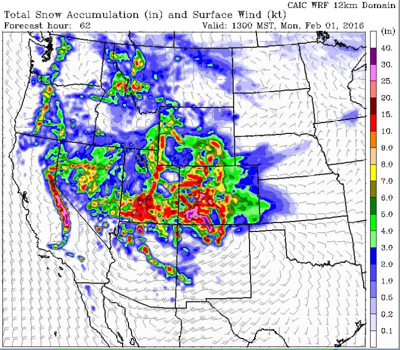
weather Big News: Big storm for the weekend. Expect windy, warm, cloudy weather today with increasing snow showers especially later in the day with heavy, dense snow late afternoon and overnight. Temperatures should drop rapidly overnight with the arrival of a cold front along with gusty, strong winds. We should have a slight break in the weather on Sunday morning but we have another, probably stronger, shot of snow from a closed low forming over us for Sunday night into Monday. Total snow accumulations are forecast to be 30-40 inches in the San Juan Mountains of Colorado and we often get similar weather here. This is potentially a major winter storm so stay tuned. Here's the National Weather Service link to the point forecast for the La Sal Mountains. Here's the total, forecast accumulation of snow by Monday. This should get your attention.
|
| general announcements Road Conditions: The road has not been plowed but vehicles have packed down the snow since the last storm and it's very passable with 4x4 and good tires. The Forest Service is working with Grand and San Juan Counties to develop a plowing solution. Please bear with us until it can be worked out. Grooming: The groomers put in a good track on Tuesday and it's still in great shape. Thanks for sending in your observations. You can view Moab observations here. To post an observation go here. To receive this advisory by email go here. This information does not apply to developed ski areas or highways where avalanche control is normally done. This advisory is from the U.S.D.A. Forest Service, which is solely responsible for its content. This advisory describes general avalanche conditions and local variations always exist. |