| Please join us at the 23rd annual Black Diamond Fall Fundraiser Party Thursday Sept 15. Tickets are on sale now here, at the Black Diamond store & at REI. Special bonus raffle for online ticket purchasers! |
| Please join us at the 23rd annual Black Diamond Fall Fundraiser Party Thursday Sept 15. Tickets are on sale now here, at the Black Diamond store & at REI. Special bonus raffle for online ticket purchasers! |
| Advisory: Moab Area Mountains | Issued by Eric Trenbeath for Sunday - January 24, 2016 - 6:50am |
|---|

|
bottom line Today the avalanche danger is MODERATE on all aspects steeper than 35 degrees in upper elevation, wind exposed terrain that have recent deposits of wind drifted snow. With snow and wind in the forecast, the danger could rise to CONSIDERABLE on steep, upper elevation slopes that face N-E-SE. Out of the wind zone a MODERATE avalanche danger exists on steep northerly facing aspects where it may be possible to trigger a lingering, persistent slab avalanche.
|
 |
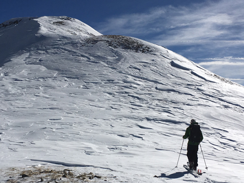
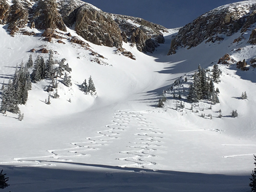
current conditions Snow has not yet begun to fall, and heavily wind damaged snow exists above tree line and in open exposed bowls. Beakable sun crust covers southerly aspects. Let's hope today's forecasted snow will freshen things up a bit, though with amounts of 3-5" accompanied by strong winds, it may take some hunting to find where it lands. Southwesterly winds have averaged 20-25 mph along ridge tops for the past 24 hours with gusts as high as 40. They've backed off slightly this morning but should increase throughout the day. Temperatures at Geyser Pass trailhead barely dipped below freezing overnight, but it's currently 22 degrees at 10,000' in Gold Basin, and 15 on Pre Laurel Peak. Base depth in gold Basin: 60" Winds, temperature and humidity on Pre-Laurel Peak New snow totals, temperature and humidity in Gold Basin Total snow depth and temperature at Geyser Pass Trailhead
Get above tree line and the wind starts to leave its mark.
Climb higher and it gets worse still.
But it you keep searching, you can still turn up some decent snow.
|
 |
recent activity
|
| type | aspect/elevation | characteristics |
|---|

|

|
LIKELIHOOD
 LIKELY
UNLIKELY
SIZE
 LARGE
SMALL
TREND
 INCREASING DANGER
SAME
DECREASING DANGER
|
|
description
We've got the wind, and we've got snow in the forecast. How much we get will determine the extent of the danger. Be on the lookout today for developing wind slabs on the lee sides of ridge crests and terrain features in upper elevation, wind exposed terrain, and avoid slopes steeper than 35 degrees where you can detect recent deposits of wind drifted snow. A triggered wind slab also has the potential to break down into buried, weak faceted snow causing a deeper and more dangerous persistent slab avalanche.
|
| type | aspect/elevation | characteristics |
|---|

|

|
LIKELIHOOD
 LIKELY
UNLIKELY
SIZE
 LARGE
SMALL
TREND
 INCREASING DANGER
SAME
DECREASING DANGER
|
|
description
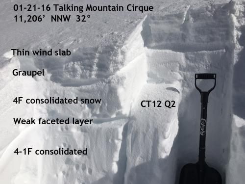
We've crept back into the woods as far as persistent slab problems go and the snowpack is becoming a bit complex. Over the past week, new snow and occasional wind slabs have formed over weak, near surface facets. Several inches of graupel have stacked on top of that followed by another round of wind slab development. Additionally, slopes that avalanched over Christmas, have now filled in just enough to become repeat offenders due to the presence of weak, faceted snow on the old bed surface. The only way to really know what's going on under the surface is to dig in and have a look. And this is the only prudent approach when considering getting on slopes steeper than about 35 degrees, particularly those with a NW-N-E aspect.
In areas where the snowpack is deep, most of our problems are confined to the upper levels. The snow shown here goes down for another 30" or so. We found the weak faceted layer to be fairly reactive, and in areas where a greater load, or more cohesive slab is overlying it, it would be possible to trigger an avalanche. Additionally, loose graupel near the surface can be a waek layer, though usually for a shorter period of time. Here it has pooled up under a rock band and is several inches thick. If you manage to find a thicker slab overriding it than the one pictured, you could find yourself going for a ride, and possibly then stepping down to the weak faceted layer below. The CT12 Q2 sheer translates to a moderately easy sheer, meaning that it would be moderately easy to trigger an avalanche.
|
 |
weather A somewhat disorganized Pacific storm will move through our area today bringing snow to the mountains around mid morning. 3-5" are possible. Gusty winds to 40 mph will accompany the cold front, first from the SW and then shifting to NW after the frontal passage. Today Snow showers, mainly before 5pm, then snow likely after 5pm. High near 24. Blustery, with a west southwest wind 15 to 25 mph becoming northwest in the afternoon. Winds could gust as high as 40 mph. Chance of precipitation is 90%. Total daytime snow accumulation of 3 to 5 inches possible. Tonight Snow likely, mainly before 9pm. Mostly cloudy, with a low around 6. Wind chill values as low as -10. Blustery, with a northwest wind 20 to 25 mph decreasing to 15 to 20 mph after midnight. Winds could gust as high as 40 mph. Chance of precipitation is 60%. New snow accumulation of less than one inch possible. Monday A 40 percent chance of snow, mainly before 10am. Partly sunny, with a high near 16. Wind chill values as low as -10. North wind 10 to 15 mph. Monday Night A 10 percent chance of snow after 11pm. Partly cloudy, with a low around 7. South wind 5 to 10 mph becoming north northwest after midnight. Tuesday Sunny, with a high near 20. North wind 10 to 15 mph. |
| general announcements Grooming Conditions: Trails were groomed yesterday. Thanks for sending in your observations. You can view Moab observations here. To post an observation go here. To receive this advisory by email go here. This information does not apply to developed ski areas or highways where avalanche control is normally done. This advisory is from the U.S.D.A. Forest Service, which is solely responsible for its content. This advisory describes general avalanche conditions and local variations always exist. |