| Please join us at the 23rd annual Black Diamond Fall Fundraiser Party Thursday Sept 15. Tickets are on sale now here, at the Black Diamond store & at REI. Special bonus raffle for online ticket purchasers! |
| Please join us at the 23rd annual Black Diamond Fall Fundraiser Party Thursday Sept 15. Tickets are on sale now here, at the Black Diamond store & at REI. Special bonus raffle for online ticket purchasers! |
| Advisory: Moab Area Mountains | Issued by Eric Trenbeath for Friday - January 22, 2016 - 7:01am |
|---|

|
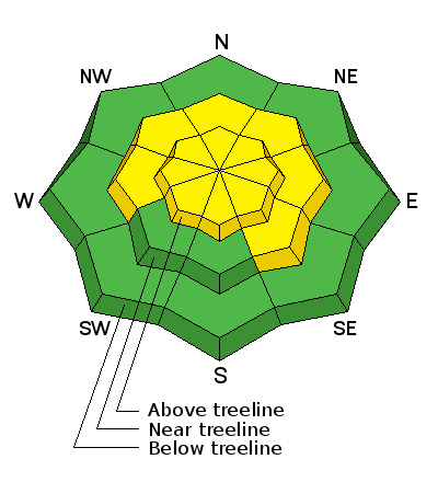
bottom line Today the avalanche danger is MODERATE on slopes steeper than 35 degrees where the danger exists for triggering an avalanche on a buried, persistent weak layer.This danger is most prevalent on upper elevation slopes with a NW-N-E aspects, but other areas remain suspect. Careful slope analysis is required for venturing into this type of terrain. Out of the wind zone at lower elevations, the avalanche danger is generally LOW.
|
 |
special announcement Our sincere condolences go out to the family and friends of Douglas Green who was killed in an avalanche while skiing the south face of Gobbler's Knob in the Wasatch Mountains yesterday. Here is the preliminary accident report.
|
 |
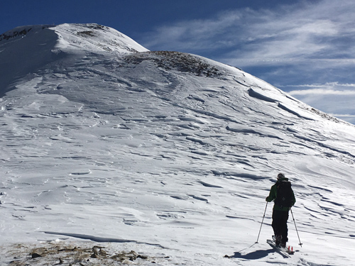
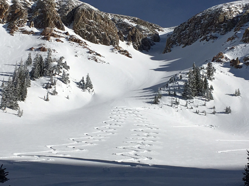
current conditions We picked about 7" of snow this week, and winds finally tapered off yesterday afternoon after a fairly wild run. Shifting from SW to NW and blowing in the 40 mph range, they have had there way with the snow surface on most exposed aspects. In addition, the sun was warm and strong yesterday, so expect south facing slopes to be crusted over today. Nevertheless, diligent seekers can still find soft snow, mainly below tree line, and surprisingly, a few upper elevation bowls have been spared. Reed Kennard sent in this observation. Thanks Reed! Ridge top winds this morning are light and northwesterly, blowing in the single digits, and it's a balmy 25 degrees at the Geyser Pass Trailhead. Base depth in gold Basin: 61" Winds, temperature and humidity on Pre-Laurel Peak New snow totals, temperature and humidity in Gold Basin Total snow depth and temperature at Geyser Pass Trailhead
Get above tree line and the wind starts to leave its mark.
Climb higher and it gets worse still.
But it you keep searching, you can still turn up some decent snow.
|
 |
recent activity
|
| type | aspect/elevation | characteristics |
|---|

|
|
LIKELIHOOD
 LIKELY
UNLIKELY
SIZE
 LARGE
SMALL
TREND
 INCREASING DANGER
SAME
DECREASING DANGER
|
|
description
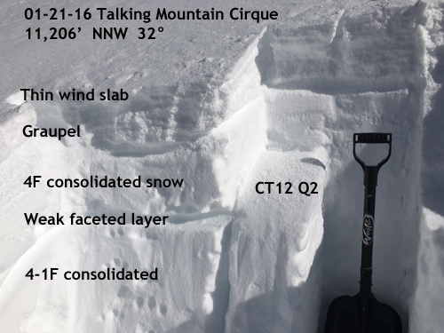
We've crept back into the woods as far as persistent slab problems go and the snowpack is becoming a bit complex. Over the past week, new snow and occasional wind slabs have formed over weak, near surface facets. Several inches of graupel have stacked on top of that followed by another round of wind slab development. Additionally, slopes that avalanched over Christmas, have now filled in just enough to become repeat offenders due to the presence of weak, faceted snow on the old bed surface. The only way to really know what's going on under the surface is to dig in and have a look. And this is the only prudent approach when considering getting on slopes steeper than about 35 degrees, particularly those with a NW-N-E aspect. This danger is also present on upper elevation sun exposed aspects, but I think after another day of warm sun, we'll see those slopes lock up for the time being.
In areas where the snowpack is deep, most of our problems are confined to the upper levels. The snow here goes down for another 30" or so. We found the weak faceted layer to be fairly reactive, and in areas where a greater load, or more cohesive slab is overlying it, it would be possible to trigger an avalanche. Additionally, loose graupel near the surface can be a waek layer, though usually for a shorter period of time. Here it has pooled up under a rock band and is several inches thick. If you manage to find a thicker slab overriding it than the one pictured, you could find yourself going for a ride, and possibly then stepping down to the weak faceted layer below. The CT12 Q2 sheer translates to a moderately easy sheer, meaning that it would be moderately easy to trigger an avalanche.
|
 |
weather Today Mostly sunny, with a high near 23. West southwest wind 5 to 15 mph. Tonight Mostly cloudy, with a low around 15. Southwest wind around 15 mph. Saturday A 10 percent chance of snow after 2pm. Mostly cloudy, with a high near 22. South southwest wind around 15 mph. Saturday Night Snow likely, mainly after 11pm. Cloudy, with a low around 14. Breezy, with a south southwest wind around 20 mph. Chance of precipitation is 70%. New snow accumulation of 1 to 3 inches possible. Sunday Snow. High near 19. West southwest wind around 15 mph becoming northwest in the morning. Chance of precipitation is 80%. Sunday Night A 50 percent chance of snow. Mostly cloudy, with a low around 8. Monday A 20 percent chance of snow before 11am. Mostly sunny, with a high near 18. |
| general announcements Grooming Conditions: Trails were groomed yesterday. Thanks for sending in your observations. You can view Moab observations here. To post an observation go here. To receive this advisory by email go here. This information does not apply to developed ski areas or highways where avalanche control is normally done. This advisory is from the U.S.D.A. Forest Service, which is solely responsible for its content. This advisory describes general avalanche conditions and local variations always exist. |