| Please join us at the 23rd annual Black Diamond Fall Fundraiser Party Thursday Sept 15. Tickets are on sale now here, at the Black Diamond store & at REI. Special bonus raffle for online ticket purchasers! |
| Please join us at the 23rd annual Black Diamond Fall Fundraiser Party Thursday Sept 15. Tickets are on sale now here, at the Black Diamond store & at REI. Special bonus raffle for online ticket purchasers! |
| Advisory: Moab Area Mountains | Issued by Eric Trenbeath for Wednesday - January 20, 2016 - 6:47am |
|---|


|
bottom line Today the avalanche danger is MODERATE on upper elevation slopes steeper than 35 degrees where you can detect recent deposits of wind drifted snow. With a forecasted increase in winds, this danger could rise to CONSIDERABLE, particularly on steep slopes with a more easterly component to them. Out of the wind zone at lower elevations, the avalanche danger is generally LOW.
|
 |
special announcement
|
 |
current conditions Another 2" of snow fell last night bringing our total up to between 5-7" over the last 36 hours. Not exactly a deep but certainly a refresh, and conditions should be markedly improved, especially in wind sheltered areas. Winds between 5:00 pm and midnight last night averaged 25 mph with gusts in the 40's from the southwest. They are light and northwesterly this morning but should increase throughout the day. It's 23 degrees at the Geyser Pass Trailhead and 13 on Pre Laurel Peak. Base depth in gold Basin: 62" Winds, temperature and humidity on Pre-Laurel Peak New snow totals, temperature and humidity in Gold Basin Total snow depth and temperature at Geyser Pass Trailhead
|
 |
recent activity
|
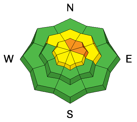
| type | aspect/elevation | characteristics |
|---|

|
|
LIKELIHOOD
 LIKELY
UNLIKELY
SIZE
 LARGE
SMALL
TREND
 INCREASING DANGER
SAME
DECREASING DANGER
|
|
description
Wind slabs old and new will be the primary concern today. Expect to find them on the lee sides of ridge crests and terrain features in wind exposed terrain and avoid slopes steeper than 35 degrees where you can detect recent deposits of wind drifted snow. With winds forecasted to increase today expect the danger to rise.
|
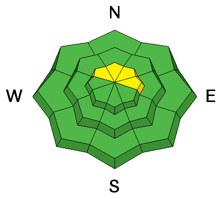
| type | aspect/elevation | characteristics |
|---|

|
|
LIKELIHOOD
LIKELY
UNLIKELY
SIZE
LARGE
SMALL
TREND
 INCREASING DANGER
SAME
DECREASING DANGER
|
|
description
Older slabs that formed over the weekend are now covered up by several inches of new snow as well as fresh new deposits of wind drifted snow. The old slabs are resting over weak, near surface facets, and this constitutes a new persistent slab problem. I haven't been out to see how reactive these slabs are, but I suspect it is now possible to trigger slides down to this buried weak layer. Additionally, slopes that avalanched over Christmas, have now filled in just enough to become repeat offenders due to the presence of weak, faceted snow on the old bed surface. The only way to know for sure what the extent of this problem is, is to dig down into the snow and see for yourself. I'll be up tomorrow and will try to get a better feel for this developing new problem, but in the meantime, view steep slopes with a northerly aspect as suspect. |
 |
weather Today Snow likely, mainly before 7am. Patchy fog between noon and 3pm. Otherwise, mostly cloudy, with a high near 23. Blustery, with a west northwest wind 10 to 15 mph increasing to 20 to 25 mph in the afternoon. Winds could gust as high as 35 mph. Chance of precipitation is 60%. Total daytime snow accumulation of less than a half inch possible. Tonight A 30 percent chance of snow, mainly before 9pm. Patchy fog between midnight and 1am. Otherwise, partly cloudy, with a low around 10. Wind chill values as low as -10. Windy, with a north wind 25 to 35 mph decreasing to 15 to 25 mph after midnight. Winds could gust as high as 55 mph. Thursday Sunny, with a high near 24. North northeast wind around 15 mph. Thursday Night Partly cloudy, with a low around 17. North northwest wind 10 to 15 mph. Friday Mostly sunny, with a high near 28. West southwest wind 10 to 15 mph. |
| general announcements Grooming Conditions: Trails were groomed yesterday but will have a couple inches of new snow on them this morning. Grooming is scheduled again for Thursday. Thanks for sending in your observations. You can view Moab observations here. To post an observation go here. To receive this advisory by email go here. This information does not apply to developed ski areas or highways where avalanche control is normally done. This advisory is from the U.S.D.A. Forest Service, which is solely responsible for its content. This advisory describes general avalanche conditions and local variations always exist. |


