| Please join us at the 23rd annual Black Diamond Fall Fundraiser Party Thursday Sept 15. Tickets are on sale now here, at the Black Diamond store & at REI. Special bonus raffle for online ticket purchasers! |
| Please join us at the 23rd annual Black Diamond Fall Fundraiser Party Thursday Sept 15. Tickets are on sale now here, at the Black Diamond store & at REI. Special bonus raffle for online ticket purchasers! |
| Advisory: Moab Area Mountains | Issued by Eric Trenbeath for Tuesday - January 19, 2016 - 6:48am |
|---|


|
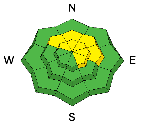
bottom line Today there is a MODERATE danger for triggering stiff and stubborn wind slabs along the lee sides of upper elevation ridge crests and terrain features, primarily on slopes with a NW-E-SE aspect. With more snow in the forecast, the danger could rise to CONSIDERABLE by tomorrrow. Out of the wind zone, the avalanche danger is generally LOW.
|
 |
special announcement
|
 |
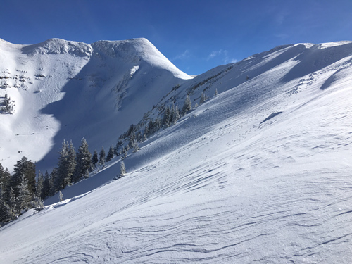
current conditions A fast moving shortwave to our north left us with about 3" of new snow overnight. Not a lot but we'll take it as the snow surface is getting pretty worn out. Open bowls on the shady side have been scoured and wind crusted, while sun exposed slopes have developed breakable melt freeze crusts. Skies are clear over Moab, but a band of clouds is hanging over the mountains this morning. Clouds will increase ahead of the next system. Southwest winds blew most of the day yesterday averaging 20-25 mph and gusting to 40 along ridge tops. They backed off last night, shifting to northwesterly, and are currently averaging 10 mph. It's currently 12 degrees on Pre Laurel Peak and 18 at the Geyser Pass trailhead. Base depth in gold Basin: 60" Winds, temperature and humidity on Pre-Laurel Peak New snow totals, temperature and humidity in Gold Basin Total snow depth and temperature at Geyser Pass Trailhead
Wind affected snow in exposed terrain. Scoured surfaces are alternating with stiff wind slabs.
|
 |
recent activity
|
| type | aspect/elevation | characteristics |
|---|

|
|
LIKELIHOOD
 LIKELY
UNLIKELY
SIZE
 LARGE
SMALL
TREND
 INCREASING DANGER
SAME
DECREASING DANGER
|
|
description
Stiff wind slabs formed over the weekend were still showing signs of cracking yesterday. Though mostly isolated, they are fairly well scattered with random abandon in wind exposed terrain, on slopes with a NW-N-SE aspect. Slabs vary from a few inches up to 18" deep. Nuanced terrain features play a key role - one side will be scoured - the other will have a smooth rounded deposit of wind drifted snow. Slabs today will be covered by a few inches of new snow so pay attention to areas that have stiff, hollow feel underneath and avoid slopes steeper than 35 degrees where they are present. For the future - these slabs have formed over several inches of loose snow, or snow with near surface facets. This is destined to become our next persistent slab problem.
Cracking in the snow up to 18" along the lee sides of upper elevation ridge crests and terrain features.
|
 |
weather The next in a series of fast moving shortwaves on a northwest flow will clip by us tonight followed by another on Wednesday bringing us the possibility for another 3-7" of new snow. Today A 50 percent chance of snow, mainly before 11am. Mostly cloudy, with a high near 21. North wind 5 to 10 mph becoming south in the afternoon. Total daytime snow accumulation of less than a half inch possible. A ridge of high pressure develops on Thursday that will keep us under mostly clear skies into Saturday. Tonight Snow. Low around 14. Breezy, with a southwest wind 15 to 20 mph. Chance of precipitation is 80%. New snow accumulation of 3 to 7 inches possible. Wednesday Snow likely. Cloudy, with a high near 19. West wind 10 to 15 mph. Chance of precipitation is 70%. New snow accumulation of 1 to 2 inches possible. Wednesday Night A 40 percent chance of snow, mainly before 11pm. Areas of blowing snow after 11pm. Mostly cloudy, then gradually becoming mostly clear, with a low around 6. Wind chill values as low as -15. Windy, with a north northwest wind 20 to 30 mph, with gusts as high as 40 mph. Thursday Sunny, with a high near 23. Blustery, with a north wind 15 to 20 mph. Thursday Night Partly cloudy, with a low around 14. Friday Mostly sunny, with a high near 26. |
| general announcements Thanks for sending in your observations. You can view Moab observations here. To post an observation go here. To receive this advisory by email go here. This information does not apply to developed ski areas or highways where avalanche control is normally done. This advisory is from the U.S.D.A. Forest Service, which is solely responsible for its content. This advisory describes general avalanche conditions and local variations always exist. |