| Please join us at the 23rd annual Black Diamond Fall Fundraiser Party Thursday Sept 15. Tickets are on sale now here, at the Black Diamond store & at REI. Special bonus raffle for online ticket purchasers! |
| Please join us at the 23rd annual Black Diamond Fall Fundraiser Party Thursday Sept 15. Tickets are on sale now here, at the Black Diamond store & at REI. Special bonus raffle for online ticket purchasers! |
| Advisory: Moab Area Mountains | Issued by Eric Trenbeath for Saturday - January 16, 2016 - 6:12am |
|---|

|
bottom line Today there is a MODERATE danger for triggering shallow wind slabs along the lee sides of upper elevation ridge crests and terrain features, primarily on slopes with a N-E-SE aspect. Out of the wind zone, the avalanche danger is generally LOW, though a very isolated or MODERATE danger still exists on steep, northerly facing aspects for triggering a deep slab avalanche. This danger exists primarily in areas of rocky, more radical terrain, and in areas with a thin snowpack.
|
 |
current conditions The mountains picked up about 3" of new snow yesterday, just enough to freshen things up a bit in sheltered locations. Where the underlying snow surface was already soft, the new snow will have worked wonders. In sun and wind exposed terrain, you will still feel old crusts beneath the surface. Moderate SW winds yesterday morning shifted to NW around noon, spiking briefly into the 25-30 mph range. They are currently blowing in the low teens from the NW. It's 13 degrees at the Geyser Pass Trailhead and 3 on Pre Laurel Peak. The north winds are going to add an additional chill so dress warm out there today. Base depth in gold Basin: 61" Winds, temperature and humidity on Pre-Laurel Peak New snow totals, temperature and humidity in Gold Basin Total snow depth and temperature at Geyser Pass Trailhead
|
 |
recent activity
|
| type | aspect/elevation | characteristics |
|---|

|

|
LIKELIHOOD
 LIKELY
UNLIKELY
SIZE
 LARGE
SMALL
TREND
 INCREASING DANGER
SAME
DECREASING DANGER
|
|
description
Expect to find new shallow wind slabs along the lee sides of upper elevation ridge crests and terrain features, primarily on slopes with a N-E-SE aspect. Though not currently posing much of a threat, be alert to an increase in winds which will move more snow around, resulting in the formation of deeper deposits of drifted snow. With a few more inches of snow possible tonight, and with a forecasted increase in winds, this danger will likely rise by tomorrow.
|
| type | aspect/elevation | characteristics |
|---|

|

|
LIKELIHOOD
LIKELY
UNLIKELY
SIZE
 LARGE
SMALL
TREND
 INCREASING DANGER
SAME
DECREASING DANGER
|
|
description
The chances of triggering a deep slab avalanche are becoming increasingly unlikely. Areas where you may still encounter this problem are on steep, northerly facing aspects, particularly in areas of rocky, more radical terrain, and in areas with a shallower snowpack. It's all about trigger points and finding the sweet spot now. Avoid thinner areas around rock outcroppings, tree islands, and along the edges of slopes.
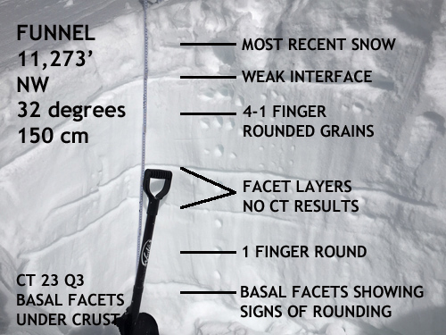
This snowpit dug in the Funnel is fairly representative of what I've been finding on other north facing slopes above 11,000'. Mid level facet layers are becoming non-reactive to stability tests, and the snowpack above the basal facets is very strong, and more than 4' deep. |
 |
weather Mostly clear skies this morning should give way to developing clouds and a chance of snow this afternoon. A series of weak disturbances on a zonal flow will continue to bring mostly clouds to our area with occasional chances at snow showers over the next several days. Saturday A 50 percent chance of snow, mainly after 2pm. Mostly cloudy, with a high near 18. Wind chill values as low as -10. West northwest wind 10 to 15 mph. New snow accumulation of less than a half inch possible. Saturday Night A 50 percent chance of snow. Mostly cloudy, with a low around 13. Northwest wind around 15 mph, with gusts as high as 25 mph. New snow accumulation of 1 to 2 inches possible. Sunday A 30 percent chance of snow, mainly before 11am. Areas of blowing snow before 11am. Partly sunny, with a high near 23. Northwest wind around 15 mph. Sunday Night Mostly cloudy, with a low around 13. Blustery, with a west northwest wind 15 to 20 mph. M.L.King Day A 20 percent chance of snow after 11am. Areas of blowing snow after 11am. Mostly cloudy, with a high near 25. Breezy.
|
| general announcements Grooming: All trails were groomed yesterday, but they will be coated with a few inches of fresh snow this morning. Thanks for sending in your observations. You can view Moab observations here. To post an observation go here. To receive this advisory by email go here. This information does not apply to developed ski areas or highways where avalanche control is normally done. This advisory is from the U.S.D.A. Forest Service, which is solely responsible for its content. This advisory describes general avalanche conditions and local variations always exist. |