| Please join us at the 23rd annual Black Diamond Fall Fundraiser Party Thursday Sept 15. Tickets are on sale now here, at the Black Diamond store & at REI. Special bonus raffle for online ticket purchasers! |
| Please join us at the 23rd annual Black Diamond Fall Fundraiser Party Thursday Sept 15. Tickets are on sale now here, at the Black Diamond store & at REI. Special bonus raffle for online ticket purchasers! |
| Advisory: Moab Area Mountains | Issued by Eric Trenbeath for Friday - January 15, 2016 - 6:19am |
|---|

|
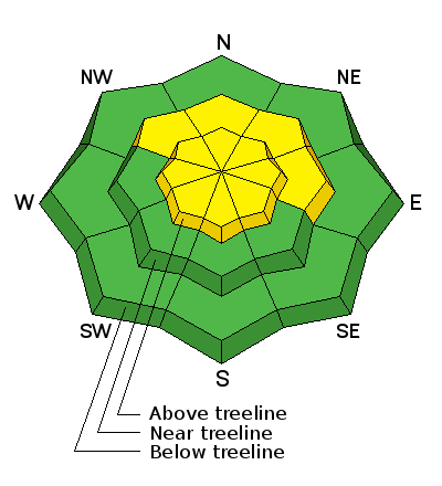
bottom line In the upper elevation wind zone, there is a MODERATE avalanche danger on all aspects where you can detect recent deposits of wind drifted snow. Out of the wind zone, the avalanche danger is generally LOW, though a very isolated or MODERATE danger still exists on steep, northerly facing aspects for triggering a deep slab avalanche. This danger exists primarily in areas of rocky, more radical terrain, and in areas with a thin snowpack.
|
 |
special announcement Avalanche 101 Course We have one spot left in our Avalanche 101 class starting tonight, January 15, at 7:00 p.m. with a field day tomorrow. This course is generously sponsored by Moab Gear Trader and will consist of an evening classroom session and a day out in the field. This course will cover avalanche characteristics and snowpack fundamentals, clues to instability, assessment of avalanche terrain, route finding and companion rescue. For more information, see the link below or contact me at [email protected]. https://utahavalanchecenter.org/classes/moab-backcountry-101 |
 |
current conditions Moderate winds have shifted around most of the week from NW to SW. Upper elevation, wind exposed terrain has developed some thin wind crusts, but settled powder still remains in sheltered locations. Sun exposed aspects have melt freeze crusts on them. It's been about a week now since any new snow has fallen, and some of the more popular areas are getting tracked out. Current winds are in the 15-25 mph range and westerly. It's 19 degrees at the Geyser Pass Trailhead, and 9 on Pre Laurel Peak. Base depth in gold Basin: 59" Winds, temperature and humidity on Pre-Laurel Peak New snow totals, temperature and humidity in Gold Basin Total snow depth and temperature at Geyser Pass Trailhead
Wind affected snow exists in exposed, upper elevation locations, but crusts are thin and manageable.
Drop down a bit lower, or find a more sheltered area, and people are still finding good, settled powder conditions.
|
 |
recent activity
|
| type | aspect/elevation | characteristics |
|---|

|
|
LIKELIHOOD
 LIKELY
UNLIKELY
SIZE
 LARGE
SMALL
TREND
 INCREASING DANGER
SAME
DECREASING DANGER
|
|
description
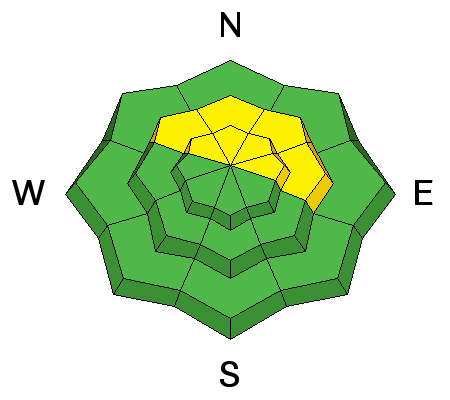
With a few inches of snow in the forecast, and with moderate SW-NW winds, we could see the development of new, shallow wind slabs at upper elevations, primarily on NE-E-SE aspects. Additionally, shifting winds earlier in the week formed isolated wind slabs on the lee slides of ridge crests and terrain features on all aspects in upper elevation, wind exposed terrain. Most of these will be shallow, stubborn to trigger, and won't pose much of a problem. Exceptions would be ares of steep, more radical terrain, where a triggered wind slab could take you over a cliff or rock band. As always, be on the lookout for smooth, rounded deposits of wind drifted snow.
|
| type | aspect/elevation | characteristics |
|---|

|
|
LIKELIHOOD
LIKELY
UNLIKELY
SIZE
 LARGE
SMALL
TREND
 INCREASING DANGER
SAME
DECREASING DANGER
|
|
description
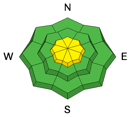
The likelihood of triggering a deep slab avalanche is becoming increasingly unlikely. Areas where you may still encounter this problem are on steep, northerly facing aspects, particularly in areas of rocky, more radical terrain, and in areas with a shallower snowpack. It's all about trigger points and finding the sweet spot now. Avoid thinner areas around rock outcroppings, tree islands, and along the edges of slopes. |
 |
weather A series of short wave troughs, primarily affecting areas to our north, will move through the region over the next several days. We'll see a little break in the "action" on Saturday. Today Snow likely, mainly between 7am and 5pm. Cloudy, with a high near 27. Southwest wind 5 to 10 mph becoming northwest in the afternoon. Chance of precipitation is 70%. Total daytime snow accumulation of 2 to 4 inches possible. Tonight A 40 percent chance of snow, mainly before 9pm. Mostly cloudy, with a low around 13. Northwest wind 5 to 10 mph. Saturday A slight chance of snow before 10am, then a chance of snow after 2pm. Mostly cloudy, with a high near 28. West northwest wind around 5 mph becoming southwest in the afternoon. Chance of precipitation is 30%. Saturday Night A 40 percent chance of snow. Mostly cloudy, with a low around 17. West northwest wind 10 to 15 mph. Sunday A 20 percent chance of snow before 11am. Partly sunny, with a high near 31. West northwest wind 10 to 15 mph. Sunday Night Mostly cloudy, with a low around 19. |
| general announcements Grooming: All trails are groomed and in excellent condition. Thanks for sending in your observations. You can view Moab observations here. To post an observation go here. To receive this advisory by email go here. This information does not apply to developed ski areas or highways where avalanche control is normally done. This advisory is from the U.S.D.A. Forest Service, which is solely responsible for its content. This advisory describes general avalanche conditions and local variations always exist. |


