| Please join us at the 23rd annual Black Diamond Fall Fundraiser Party Thursday Sept 15. Tickets are on sale now here, at the Black Diamond store & at REI. Special bonus raffle for online ticket purchasers! |
| Please join us at the 23rd annual Black Diamond Fall Fundraiser Party Thursday Sept 15. Tickets are on sale now here, at the Black Diamond store & at REI. Special bonus raffle for online ticket purchasers! |
| Advisory: Moab Area Mountains | Issued by Eric Trenbeath for Monday - January 11, 2016 - 6:12am |
|---|

|
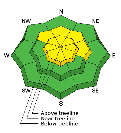
bottom line The avalanche danger is MODERATE on mid and upper elevation slopes steeper than 35 degrees that face W-N-E, and in areas where you can detect recent deposits of wind drifted snow.
|
 |
special announcement This advisory is based on field work performed, and observations received, over the weekend of Jan 9-10. It is to be used as a baseline for forming your own danger analysis over the next few days. Changing weather conditions can rapidly change the avalanche danger. Use the weather links under Current Conditions to stay abreast of wind, temperature and new snow totals. Barring a significant change in the weather, this advisory will be updated on Friday, January 15. Avalanche 101 Course The Utah Avalanche Center-Moab will be hosting an Avalanche 101 class on January 15,16. This course is generously sponsored by Moab Gear Trader and will consist of an evening classroom session and a day out in the field. This course will cover avalanche characteristics and snowpack fundamentals, clues to instability, assessment of avalanche terrain, route finding and companion rescue. For more information, see the link below or contact me at [email protected]. https://utahavalanchecenter.org/classes/moab-backcountry-101 |
 |
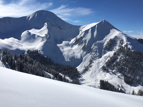
current conditions Northerly winds bumped up this morning after what has been an incredible run of windless days and primo powder conditions. They are currently averaging 20 mph on Pre Laurel Peak, and if they keep up, it will spell the end for light, fluffy powder in exposed, upper elevation terrain. Sheltered northerly aspects will remain excellent, while south facing slopes finally took a hit from the sun. Expect to find them crusted over today. It is currently 10 degrees on Pre Laurel Peak and 11 at the Geyser Pass Trailhead. Winds, temperature and humidity on Pre-Laurel Peak New snow totals, temperature and humidity in Gold Basin Total snow depth and temperature at Geyser Pass Trailhead
It's looking mighty white out there! Sunday was the last day for good powder on south facing.
North facing aspects held amazing snow conditions on Sunday, and people were slowly creeping in to larger terrain. Increasing winds may take their toll on the snow surface in upper, alpine bowls.
|
 |
recent activity
|
| type | aspect/elevation | characteristics |
|---|

|
|
LIKELIHOOD
 LIKELY
UNLIKELY
SIZE
 LARGE
SMALL
TREND
 INCREASING DANGER
SAME
DECREASING DANGER
|
|
description
Increased northerly winds, combined with plenty of snow available for transport, will result in wind slab development on the lee sides of ride crests and terrain features in upper elevation, wind exposed terrain. Ultimately, wind speed and duration will determine the extent of this hazard. Pay attention to the trend throughout the week, and be on the look out for recent deposits of wind drifted snow.
|
| type | aspect/elevation | characteristics |
|---|

|

|
LIKELIHOOD
LIKELY
UNLIKELY
SIZE
 LARGE
SMALL
TREND
 INCREASING DANGER
SAME
DECREASING DANGER
|
|
description
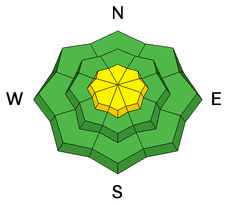
The snow pack is gaining strength and we have rounded the horn into a low probability - high consequence situation. Weak, faceted snow still exists at the bottom of the snowpack, but the greatest danger exists in areas where the snowpack remains relatively shallow. In these areas it may still be possible to trigger a full depth, deep slab avalanche. Particular caution needs to be given to areas of steep, rocky, and more radical terrain, or those areas on the periphery of slopes where pockets of trees or rock outcroppings can create shallower pockets or "trigger points" for releasing an avalanche. Mind your p's and q's and carefully analyze slopes steeper than 35 degrees that face the north half of the compass.
This snowpit we dug in the Funnel last week is also fairly representative of what I found on a north facing aspect in Middle Cirque on Sunday. Mid level facet layers were basically non reactive, and it took considerable effort to produce a failure on the basal facets at the ground. But in the right circumstances, where the pack is shallow, and the facets more pervasive, it may still be possible to trigger a dangerous, full depth avalanche.
|
 |
weather A ridge of high pressure will build over the Southwest and a dry, northwest flow will persist through midweek. A weak shortwave system will move through the area Thursday bringing a chance of snow through Friday. A weak, but short lived ridge builds again on Saturday with another storm system moving into the region on Sunday. Temperatures this week will remain cooler than usual with valley inversions. Monday Sunny, with a high near 20. Wind chill values as low as -15. North wind 10 to 15 mph. Monday Night Mostly clear, with a low around -3. Wind chill values as low as -20. North wind around 10 mph. Tuesday Mostly sunny, with a high near 23. Wind chill values as low as -20. North northwest wind around 10 mph. Tuesday Night Mostly clear, with a low around 10. North northwest wind around 5 mph. Wednesday Mostly sunny, with a high near 28. Light west wind increasing to 5 to 10 mph in the morning. Wednesday Night A 10 percent chance of snow after 11pm. Partly cloudy, with a low around 10. Thursday A 20 percent chance of snow. Partly sunny, with a high near 16. Thursday Night A chance of snow, mainly after 11pm. Mostly cloudy, with a low around 6. Friday A chance of snow. Partly sunny, with a high near 13. |
| general announcements Grooming: All trails were groomed over the weekend and nordic and skate skiing conditions are excellent. Thanks for sending in your observations. You can view Moab observations here. To post an observation go here. To receive this advisory by email go here. This information does not apply to developed ski areas or highways where avalanche control is normally done. This advisory is from the U.S.D.A. Forest Service, which is solely responsible for its content. This advisory describes general avalanche conditions and local variations always exist. |