| Please join us at the 23rd annual Black Diamond Fall Fundraiser Party Thursday Sept 15. Tickets are on sale now here, at the Black Diamond store & at REI. Special bonus raffle for online ticket purchasers! |
| Please join us at the 23rd annual Black Diamond Fall Fundraiser Party Thursday Sept 15. Tickets are on sale now here, at the Black Diamond store & at REI. Special bonus raffle for online ticket purchasers! |
| Advisory: Moab Area Mountains | Issued by Eric Trenbeath for Wednesday - January 6, 2016 - 6:45am |
|---|

|
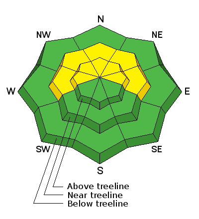
bottom line The avalanche danger is MODERATE on mid and upper elevation slopes steeper than 35 degrees that face W-N-E and in areas where you can detect recent deposits of wind drifted snow. This danger will rise throughout the day and could reach CONSIDERABLE by tomorrow if significant snow totals pan out. There also remains a MODERATE danger for triggering a deeper persistent slab avalanche on similar aspects right around tree line and above.
|
 |
special announcement The Utah Avalanche Center-Moab will be hosting an Avalanche 101 class on January 15,16. This course is generously sponsored by Moab Gear Trader and will consist of an evening classroom session and a day out in the field. This course will cover avalanche characteristics and snowpack fundamentals, clues to instability, assessment of avalanche terrain, route finding and companion rescue. For more information, see the link below or contact me at [email protected]. https://utahavalanchecenter.org/classes/moab-backcountry-101 |
 |
current conditions Trace amounts of snow have fallen overnight and as of yesterday morning, the mountains had received 3" of new. A complicated storm system is approaching our area that could deliver a decent shot of snow through tomorrow. As of this morning, there is little change in the avalanche danger, but as snow begins to pile up you will need to be alert to a corresponding rise in danger. Southerly winds are averaging in the teens but will be on the increase today. It's currently 23 degrees at 10,000'. Base depth in Gold Basin: 60" Winds, temperature and humidity on Pre-Laurel Peak New snow totals, temperature and humidity in Gold Basin Total snow depth and temperature at Geyser Pass Trailhead
|
 |
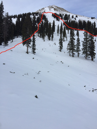
recent activity Over the weekend I went around to the east side of the range and got a good picture as to how widespread the avalanche cycle of Dec 25-26 was. The 15-20" of snow on Christmas, combined with 30-60 mph NE winds the day after, produced numerous large avalanches though many slopes stayed put. The slopes that didn't avalanche are still cause for concern. Some slides broke on basal facets to the ground, whereas others failed on a mid-level, weak faceted layer. Most of the slides occurred on northerly aspects but there were exceptions. Check out this photo of a large avalanche on the south face of Mount Tomasaki submitted by Ken Williams. The crown at the top is over 6' deep and adjacent to a scoured surface.
|
| type | aspect/elevation | characteristics |
|---|

|
|
LIKELIHOOD
 LIKELY
UNLIKELY
SIZE
 LARGE
SMALL
TREND
 INCREASING DANGER
SAME
DECREASING DANGER
|
|
description
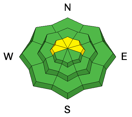
Drifting snow will be accumulating throughout the day and you will need to be alert to developing wind slabs on the lee sides of ridge crests and terrain features, primarily on slopes that face W-N-E. Look for an increasing danger on these slopes today. Be wary of smooth, rounded deposits of wind drifted snow and look for signs off instability such as cracking in the snow surface.
|
| type | aspect/elevation | characteristics |
|---|

|

|
LIKELIHOOD
LIKELY
UNLIKELY
SIZE
LARGE
SMALL
TREND
INCREASING DANGER
SAME
DECREASING DANGER
|
|
description
Persistent slab problems vary and avalanches are becoming harder to trigger. Nevertheless, consequences remain high. In areas with weak, shallow snow, it may still be possible to trigger an avalanche to the ground. This scenario is most likely in rocky, and radical terrain right around treeline, or in areas where starting zones have been repeatedly scoured out. In areas where the snowpack is deeper, a mid level facet layer is the more likely weakness. Continue to suspect slopes steeper than 35 degrees that face W-N-E that didn't run in the last cycle. Careful slope evaluation and determining whether or not a weak layer is present is essential before venturing into this terrain. |
 |
weather Today Snow. High near 25. Breezy, with a south wind 15 to 20 mph. Chance of precipitation is 100%. Total daytime snow accumulation of 3 to 7 inches possible. Tonight Snow. Low around 8. Breezy, with a southwest wind 20 to 25 mph, with gusts as high as 40 mph. Chance of precipitation is 80%. New snow accumulation of 3 to 5 inches possible. Thursday Snow. High near 16. Wind chill values as low as -15. Breezy, with a southwest wind 15 to 25 mph, with gusts as high as 40 mph. Chance of precipitation is 80%. New snow accumulation of 3 to 7 inches possible. Thursday Night Snow likely. Cloudy, with a low around 8. South southeast wind around 15 mph. Chance of precipitation is 70%. New snow accumulation of 4 to 8 inches possible. Friday Snow likely. Cloudy, with a high near 14. South wind 5 to 10 mph becoming west northwest in the morning. Chance of precipitation is 60%. |
| general announcements Thanks for sending in your observations. You can view Moab observations here. To post an observation go here. To receive this advisory by email go here. This information does not apply to developed ski areas or highways where avalanche control is normally done. This advisory is from the U.S.D.A. Forest Service, which is solely responsible for its content. This advisory describes general avalanche conditions and local variations always exist. |