| Please join us at the 23rd annual Black Diamond Fall Fundraiser Party Thursday Sept 15. Tickets are on sale now here, at the Black Diamond store & at REI. Special bonus raffle for online ticket purchasers! |
| Please join us at the 23rd annual Black Diamond Fall Fundraiser Party Thursday Sept 15. Tickets are on sale now here, at the Black Diamond store & at REI. Special bonus raffle for online ticket purchasers! |
| Advisory: Moab Area Mountains | Issued by Eric Trenbeath for Friday - December 25, 2015 - 6:40am |
|---|

|
bottom line Overall the avalanche danger is CONSIDERABLE today, but areas of HIGH danger exist in wind exposed upper elevation terrain on slopes that face N-NE-E. Avoid slopes steeper than about 30 degrees, and stay out from under steep slopes that have starting zones in wind exposed terrain.
|
 |
special announcement
|
 |
current conditions Creamy best described the conditions yesterday. 15" of dense, heavy snow kept you riding high, and trail breaking was a breeze. Storm totals overnight have fallen short at 2.5" in Gold Basin this morning, but up to a foot of snow is the forecast and conditions will remain excellent today. Winds overnight have averaged 15-20 mph from the WSW with gusts into the low 40's on Pre Laurel Peak. It's currently 19 degrees at the Geyser Pass Trailhead. Base depth in Gold Basin: 55" Base at Geyser Pass Trailhead: 42" Winds, temperature and humidity on Pre-Laurel Peak New snow totals, temperature and humidity in Gold Basin Total snow depth and temperature at Geyser Pass Trailhead
|
 |
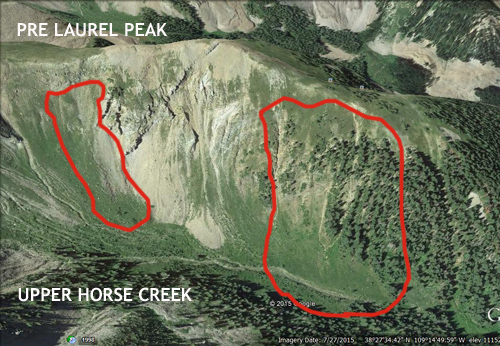
recent activity Things were eerily quiet out there yesterday until my partner and I popped up above tree line on the Laurel Highway and peered over into Horse Creek and found this large avalanche.
Observer Dave Garcia stand in front of 3' crown. Slide was 500' wide and ran for 1000'
|
| type | aspect/elevation | characteristics |
|---|

|

|
LIKELIHOOD
 LIKELY
UNLIKELY
SIZE
 LARGE
SMALL
TREND
 INCREASING DANGER
SAME
DECREASING DANGER
|
|
description
It's kind of spooky out there right now. Many slopes that I guessed would have avalanched during the storm cycle remained intact, but the Horse Creek slide confirmed that the danger is still very real. Over the past week we've received 2' of snow, 15" of that came in on Tuesday with 1.75" water weight. Wind slab on top of wind slab has been accumulating in the upper elevations, primarily on slopes facing N-NE-E and they are primed and ready for a skier or rider to cut them loose. With more snow and wind in the forecast, the probability for natural and human triggered avalanches in these areas is high. Give slopes steeper than about 30 degrees a wide birth by staying off of and out form under them.
|
| type | aspect/elevation | characteristics |
|---|

|

|
LIKELIHOOD
 LIKELY
UNLIKELY
SIZE
 LARGE
SMALL
TREND
INCREASING DANGER
SAME
DECREASING DANGER
|
|
description
Winds and blowing snow from yesterday, and today, continue to form new drifts or wind slabs on the lee sides of ridge crests and terrain features in wind exposed terrain. A triggered wind slab has the very real potential to step down into a deeper weak layer causing a dangerous persistent slab avalanche. Avoid slopes steeper than about 30 degrees where you can detect recent deposits of wind drifted snow and look for the obvious clues such as cracking or collapsing in the snowpack. |
 |
weather A Pacific storm system on a southwest flow will affect our area today bring snow and moderate SW winds. Showers may linger into Saturday as the storm exits the area bringing dry and sunny conditions by Sunday. Christmas Day Snow. Areas of blowing snow between noon and 4pm. High near 16. Breezy, with a southwest wind 5 to 10 mph becoming west 15 to 25 mph. Chance of precipitation is 100%. Total daytime snow accumulation of 7 to 11 inches possible. Tonight Snow likely. Cloudy, with a low around 7. Wind chill values as low as -10. North wind 10 to 15 mph. Chance of precipitation is 70%. New snow accumulation of 1 to 3 inches possible. Saturday A 50 percent chance of snow. Mostly cloudy, with a high near 13. Wind chill values as low as -10. Blustery, with a northeast wind 15 to 25 mph, with gusts as high as 40 mph. New snow accumulation of less than a half inch possible. Saturday Night Partly cloudy, with a low around -5. Wind chill values as low as -20. Blustery, with a northeast wind 15 to 25 mph, with gusts as high as 40 mph. Sunday Sunny, with a high near 19. East northeast wind 10 to 15 mph. |
| general announcements The road was plowed yesterday but everyone will be on their own over the weekend. Keep your eye on snow totals in this advisory and use your best judgment for getting up there this weekend. Travis got out and groomed yesterday and Kirstin is going to try and get up tomorrow. Thanks for sending in your observations. You can view Moab observations here. To post an observation go here. To receive this advisory by email go here. This information does not apply to developed ski areas or highways where avalanche control is normally done. This advisory is from the U.S.D.A. Forest Service, which is solely responsible for its content. This advisory describes general avalanche conditions and local variations always exist. |