| Please join us at the 23rd annual Black Diamond Fall Fundraiser Party Thursday Sept 15. Tickets are on sale now here, at the Black Diamond store & at REI. Special bonus raffle for online ticket purchasers! |
| Please join us at the 23rd annual Black Diamond Fall Fundraiser Party Thursday Sept 15. Tickets are on sale now here, at the Black Diamond store & at REI. Special bonus raffle for online ticket purchasers! |
| Advisory: Moab Area Mountains | Issued by Eric Trenbeath for Wednesday - December 23, 2015 - 6:49am |
|---|

|
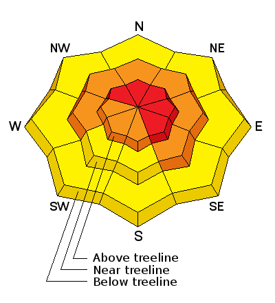
bottom line Human triggered avalanches are likely today, and the danger is HIGH in upper elevation, wind exposed terrain on slopes steeper than about 30 degrees that face NW-NE-SE. Below tree line the avalanche danger is CONSIDERABLE. Avalanches may be triggered remotely and from adjacent, lower angle slopes. Stay off of, and out from under steep terrain. Only experienced backcountry travelers with excellent route finding skills and a high level of avalanche awareness should travel in the mountains today.
|
 |
special announcement
|
 |
current conditions The mountains picked up between 10" and 15" of new snow between Monday night and yesterday afternoon. Combined with 5" from Sunday, we're up to 20" so far this week at 10,000' with more likely at upper elevations. Winds were very active during the storm, averaging in the mid 20's with gusting into the mid 40's from the southwest. They backed off into the teens and shifted to northwesterly yesterday afternoon, and in the past hour have dropped off to 10 mph. Expect them to increase today. It is currently 6 degrees on Pre Laurel Peak, and 18 at the Geyser Pass Trailhead. Winds, temperature and humidity on Pre-Laurel Peak New snow totals, temperature and humidity in Gold Basin Total snow depth and temperature at Geyser Pass Trailhead
|
 |
recent activity
|
| type | aspect/elevation | characteristics |
|---|

|
|
LIKELIHOOD
 LIKELY
UNLIKELY
SIZE
 LARGE
SMALL
TREND
 INCREASING DANGER
SAME
DECREASING DANGER
|
|
description
Strong winds combined with new snow have resulted in widespread areas of deep drifted snow, especially in upper elevation, wind exposed terrain. Stay off of and out from under steep slopes today, and in particular those that have a N-NE-E aspect. Look for signs of instability such as cracking or collapsing of the snowpack. Triggered wind slabs could be in excess of 2' deep and have the potential to step down into buried weak layers causing an even deeper and more dangerous persistent slab avalanche.
|
| type | aspect/elevation | characteristics |
|---|

|

|
LIKELIHOOD
LIKELY
UNLIKELY
SIZE
 LARGE
SMALL
TREND
 INCREASING DANGER
SAME
DECREASING DANGER
|
|
description
About an inch and a half of water weight has been added to persistent weak layers buried in our snowpack. and the condition is ripe for triggering a deep and dangerous persistent slab avalanche. This problem is most acute on slopes facing NW-N-E starting from a few hundred feet below tree line and extending into the upper elevations. These slides can be triggered remotely and from adjacent lower angle terrain. Stay off of and out from under these slopes for the foreseeable future. |
 |
weather The flow has shifted to northwest, and the last shortwave from this system will move through our area today bringing the possibility for continued light snow and moderate to strong westerly winds. We'll see a bit of a lull on Thursday before the flow again switches to southwest bringing us another significant storm system by Christmas Day. Today Snow, mainly before 3pm. High near 13. Wind chill values as low as -10. Windy, with a west wind 20 to 30 mph. Chance of precipitation is 90%. Total daytime snow accumulation of 3 to 5 inches possible. Tonight A 30 percent chance of snow, mainly after 2am. Mostly cloudy, with a low around 0. Wind chill values as low as -15. Blustery, with a west northwest wind 15 to 20 mph becoming southwest after midnight. Winds could gust as high as 30 mph. Thursday Snow likely, mainly after 2pm. Cloudy, with a high near 13. Wind chill values as low as -20. Breezy, with a south southwest wind 15 to 20 mph, with gusts as high as 30 mph. Chance of precipitation is 60%. New snow accumulation of 1 to 3 inches possible. Thursday Night Snow. Areas of blowing snow after 11pm. Low around 8. Wind chill values as low as -10. Breezy, with a south southwest wind 15 to 25 mph, with gusts as high as 40 mph. Chance of precipitation is 90%. New snow accumulation of 6 to 10 inches possible. Christmas Day Snow. Areas of blowing snow. High near 15. Breezy, with a southwest wind 15 to 25 mph, with gusts as high as 40 mph. Chance of precipitation is 90%. |
| general announcements I don't have any current plowing information but will update when information becomes available. Thanks for sending in your observations. You can view Moab observations here. To post an observation go here. To receive this advisory by email go here. This information does not apply to developed ski areas or highways where avalanche control is normally done. This advisory is from the U.S.D.A. Forest Service, which is solely responsible for its content. This advisory describes general avalanche conditions and local variations always exist. |


