| Please join us at the 23rd annual Black Diamond Fall Fundraiser Party Thursday Sept 15. Tickets are on sale now here, at the Black Diamond store & at REI. Special bonus raffle for online ticket purchasers! |
| Please join us at the 23rd annual Black Diamond Fall Fundraiser Party Thursday Sept 15. Tickets are on sale now here, at the Black Diamond store & at REI. Special bonus raffle for online ticket purchasers! |
| Advisory: Moab Area Mountains | Issued by Eric Trenbeath for Monday - December 21, 2015 - 6:21am |
|---|

|
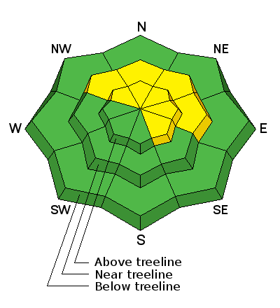
bottom line Today there is a MODERATE danger in wind exposed terrain on slopes steeper than 35 degrees that face NW-E-SE where there are recent deposits of wind drifted snow. There also remains a MODERATE but tricky avalanche danger on slopes steeper than 35 degrees that face NW-N-E due to the presence of buried persistent weak layers in the snowpack. These areas warrant extra caution for awhile due to the very real potential for triggering a dangerous persistent slab avalanche. By tomorrow, expect the danger to rise to CONSIDERABLE or possibly even HIGH depending on snow totals.
|
 |
special announcement
|
 |
current conditions Happy Solstice. Old man winter blew in and blessed us with a surprise 3-6" of new, medium density snow yesterday which will be just enough to freshen up what were already good conditions. WSW winds blew most of the day yesterday averaging 15-20 mph along ridge tops with gusts into the high 30's. Around 3:00 p.m. they backed off shifting to westerly and then to northwesterly where they currently sit in the singe digits. It's 20 degrees at the Geyser Pass trailhead and 9 on Pre Laurel Peak. Base depth in Gold Basin: 45" Base depth at Geyser Pass Trailhead: 32" Through the invaluable assistance of the indefatigable Ed Grote, the Pre Laurel Peak weather station is back on line reporting hourly wind speed and direction. We got Gold Basin sorted out as well so watch it for new snow totals this week. Winds, temperature and humidity on Pre-Laurel Peak New snow totals, temperature and humidity in Gold Basin Total snow depth and temperature at Geyser Pass Trailhead
|
 |
recent activity
|
| type | aspect/elevation | characteristics |
|---|

|
|
LIKELIHOOD
 LIKELY
UNLIKELY
SIZE
 LARGE
SMALL
TREND
 INCREASING DANGER
SAME
DECREASING DANGER
|
|
description
Yesterday's wind and new snow will likely have created fresh shallow drifts in exposed, upper elevation terrain on slopes that face NW-NE-SE. Additionally, strong winds over the weekend formed harder wind slabs in these same areas. Today you will need to have your avalanche glasses on as you look for areas of recently deposited, wind drifted snow. Look for smooth rounded pillows, and be wary of the lee sides of terrain features such as gullies and sub ridges. Areas beneath cliff bands, where eddying wind currents have allowed snow to be deposited are especially suspect. Triggered wind slabs also have the potential for stepping down into buried weak layers causing a larger and more dangerous persistent slab avalanche. With more snow and wind in the forecast tonight, expect this danger to rise significantly by tomorrow.
|
| type | aspect/elevation | characteristics |
|---|

|
|
LIKELIHOOD
 LIKELY
UNLIKELY
SIZE
 LARGE
SMALL
TREND
INCREASING DANGER
SAME
DECREASING DANGER
|
|
description
I don't believe the new snow has been enough to affect the buried weak layers in our snowpack, but a dangerous situation still exists where it might just take the weight of a skier or rider to tip the balance and trigger a dangerous persistent slab avalanche.This problem is most acute on slopes facing NW-N-E starting from a few hundred feet below tree line and extending into the upper elevations. Slopes steeper than 35 degrees are best avoided in these areas. For more details on this problem check out this great observation from Dave Garcia. Thanks Dave! |
 |
weather We'll have a little bit of a lull today before the next wave of moisture moves into our area tonight and tomorrow bringing with it the possibility for 10-18" of new snow by Wednesday morning. Another system is lined up for Christmas Day. Today Snow likely, mainly after 5 pm. Mostly cloudy, with a high near 18. Southwest wind 10 to 15 mph. Chance of precipitation is 60%. Total daytime snow accumulation of less than one inch possible. Tonight Snow. Widespread blowing snow after 9 pm. Low around 16. Breezy, with a southwest wind around 20 mph, with gusts as high as 35 mph. Chance of precipitation is 100%. New snow accumulation of 4 to 8 inches possible. Tuesday Snow. Widespread blowing snow. High near 19. Blustery, with a west southwest wind 15 to 20 mph, with gusts as high as 30 mph. Chance of precipitation is 100%. New snow accumulation of 5 to 9 inches possible. Tuesday Night Snow likely, mainly before 11pm. Widespread blowing snow before 11pm. Cloudy, with a low around 11. Blustery, with a northwest wind 20 to 25 mph, with gusts as high as 35 mph. Chance of precipitation is 60%. New snow accumulation of 1 to 3 inches possible. Wednesday Snow likely. Cloudy, with a high near 22. West northwest wind around 15 mph. Chance of precipitation is 60%. Wednesday Night A 20 percent chance of snow. Mostly cloudy, with a low around 7. Blustery. Thursday Snow likely. Cloudy, with a high near 17. Chance of precipitation is 70%. Thursday Night Snow likely. Cloudy, with a low around 11. Christmas Day Snow likely. Cloudy, with a high near 17. |
| general announcements Expect to find a few inches of new snow on the road to the Geyser Pass trailhead this morning. Travis groomed yesterday but his efforts are now covered by 3-5" of fresh snow. Thanks for sending in your observations. You can view Moab observations here. To post an observation go here. To receive this advisory by email go here. This information does not apply to developed ski areas or highways where avalanche control is normally done. This advisory is from the U.S.D.A. Forest Service, which is solely responsible for its content. This advisory describes general avalanche conditions and local variations always exist. |


