| Please join us at the 23rd annual Black Diamond Fall Fundraiser Party Thursday Sept 15. Tickets are on sale now here, at the Black Diamond store & at REI. Special bonus raffle for online ticket purchasers! |
| Please join us at the 23rd annual Black Diamond Fall Fundraiser Party Thursday Sept 15. Tickets are on sale now here, at the Black Diamond store & at REI. Special bonus raffle for online ticket purchasers! |
| Advisory: Moab Area Mountains | Issued by Eric Trenbeath for Saturday - December 19, 2015 - 6:30am |
|---|


|
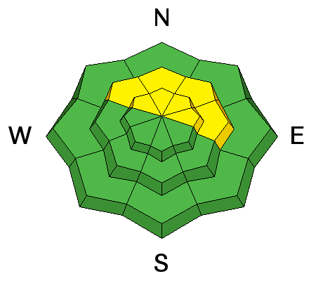
bottom line A MODERATE and very tricky avalanche danger exists on slopes steeper than 35 degrees that face NW-N-E due to the presence of buried persistent weak layers in the snowpack. These areas are best avoided due to the very real potential for triggering a dangerous persistent slab avalanche. Also be alert to a rising MODERATE danger for recently deposited wind slabs in upper elevation, wind exposed terrain primarily on the lee sides of ridge crests that face N-NE-E.
|
 |
special announcement
|
 |
current conditions The 2' of snow we received on Monday has settled to about a foot, and conditions remain excellent in sheltered areas. Sun and warm temperatures yesterday finished off the southerly aspects and they will be well crusted over today. 24 hour winds have been light from the southwest but they've begun to pick up this morning and will increase throughout the day. They are currently averaging 15 mph with gusts to 25. It is a balmy 33 degrees at the Geyser Pass Trailhead. We are experiencing technical difficulties with two out of three weather stations but hope to be able to fix that this weekend. Winds, temperature and humidity on Pre-Laurel Peak New snow totals, temperature and humidity in Gold Basin Total snow depth and temperature at Geyser Pass Trailhead
|
 |
recent activity
|
| type | aspect/elevation | characteristics |
|---|

|
|
LIKELIHOOD
 LIKELY
UNLIKELY
SIZE
 LARGE
SMALL
TREND
 INCREASING DANGER
SAME
DECREASING DANGER
|
|
description
The snow from earlier this week has settled into place, and gone are existing signs of instability. However, layers of weak faceted snow exist in the snowpack, and we've moved into a tricky phase where it might just take the additional weight of a skier or rider to trigger a dangerous persistent slab avalanche. This problem is most acute on slopes facing NW-N-E starting from a few hundred feet below treeline and extending into the upper elevations. Slopes steeper than 35 degrees are best avoided in these areas. For more details on this problem check out this great observation from Dave Garcia. Thanks Dave! |
| type | aspect/elevation | characteristics |
|---|

|

|
LIKELIHOOD
 LIKELY
UNLIKELY
SIZE
 LARGE
SMALL
TREND
 INCREASING DANGER
SAME
DECREASING DANGER
|
|
description
With winds on the rise, be alert to increased wind slab development in exposed, upper elevation terrain. This danger will be most prevalent on slopes that face NW-NE-E. Look for recent deposits of wind drifted snow on the lee sides of ridge crests and terrain features, and be alert to signs of instability of such as cracking or collapsing. A triggered wind slab also has the danger of stepping down into buried weak layers causing a larger and more dangerous persistent slab avalanche. |
 |
weather Today will be the last mostly sunny day for awhile as a series of Pacific storm systems are lining up for a potentially snowy and wintry week. The first trough in the series will weaken as it moves through our area on Sunday but we could see a couple inches of snow. We'll get a little break on Monday before a stronger impulse moves through Tues-Wed followed by another Christmas Day. Today Mostly sunny, with a high near 36. Breezy, with a south southwest wind 15 to 20 mph, with gusts as high as 30 mph. Tonight A 20 percent chance of snow after 11pm. Mostly cloudy, with a low around 15. Breezy, with a south southwest wind 20 to 25 mph. Sunday Snow likely, mainly before 11am. Mostly cloudy, with a high near 17. Breezy, with a west southwest wind 20 to 25 mph decreasing to 10 to 15 mph in the afternoon. Winds could gust as high as 45 mph. Chance of precipitation is 70%. New snow accumulation of 1 to 2 inches possible. Sunday Night A 10 percent chance of snow. Mostly cloudy, with a low around 11. West northwest wind 10 to 15 mph, with gusts as high as 25 mph. Monday Partly sunny, with a high near 18. Blustery, with a west northwest wind 15 to 20 mph. |
| general announcements San Juan county did an excellent job plowing and the road is open. Travis will be up grooming today. Thanks for sending in your observations. You can view Moab observations here. To post an observation go here. To receive this advisory by email go here. This information does not apply to developed ski areas or highways where avalanche control is normally done. This advisory is from the U.S.D.A. Forest Service, which is solely responsible for its content. This advisory describes general avalanche conditions and local variations always exist. |


