| Please join us at the 23rd annual Black Diamond Fall Fundraiser Party Thursday Sept 15. Tickets are on sale now here, at the Black Diamond store & at REI. Special bonus raffle for online ticket purchasers! |
| Please join us at the 23rd annual Black Diamond Fall Fundraiser Party Thursday Sept 15. Tickets are on sale now here, at the Black Diamond store & at REI. Special bonus raffle for online ticket purchasers! |
| Advisory: Moab Area Mountains | Issued by Eric Trenbeath for Monday - December 14, 2015 - 7:10am |
|---|

|
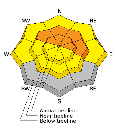
bottom line Expect a rising hazard today as new snow accompanied by wind, could push the avalanche danger to CONSIDERABLE at and above tree line. This means that natural avalanches are possible and human triggered avalanches are likely. Backcountry travelers should avoid steep terrain today, particularly on slopes that face the north half of the compass. This danger applies both to recently deposited wind slabs, and deeper, persistent slab avalanches.
|
 |
special announcement The Utah Avalanche Center-Moab will be presenting a free Know Before You Go avalanche awareness presentation at the Grand County Library on Thursday, December 17 at 6:30 p.m. Call the Manti-La Sal National Forest office at 435-259-7155 fro more information.
|
 |
current conditions A decent storm is on our doorstep, but as of 5:00 a.m. snow had not yet begun to fall. By mid morning we should see a period of heavy snow. We could see 5" -9" today and another 3-5" are possible tonight. Overnight winds have been on the increase, averaging 15-20 mph from the SW and then switching to the SE at 25 mph with gusts to 40. Base depth in Gold Basin: 30" Base depth at Geyser Pass Trailhead: 20" Winds, temperature and humidity on Pre-Laurel Peak New snow totals, temperature and humidity in Gold Basin Total snow depth and temperature at Geyser Pass Trailhead
|
 |
recent activity A skier triggered avalanche occurred over the weekend in Gold Basin. Varying from 3" to 12" deep, the slab ran on a faceted weak layer, which serves as a portent for future persistent slab problems. No one was caught or carried, and the skier was able to quickly ski out of it. You can read more about it here.
|
| type | aspect/elevation | characteristics |
|---|

|
|
LIKELIHOOD
 LIKELY
UNLIKELY
SIZE
 LARGE
SMALL
TREND
 INCREASING DANGER
SAME
DECREASING DANGER
|
|
description
Today is one off those days where you will need to be alert to a rising avalanche danger as the day progresses. New snow will be blown into sensitive drifts on the lee sides of ridge crests and terrain features in wind exposed terrain. The danger will be most pronounced on slopes facing the north half of the compass and you should stay off of, and out from under, steep terrain on these aspects. If triggered, new wind slabs will have the potential to step down into older weaker snow causing a deeper and more dangerous persistent slab avalanche. |
| type | aspect/elevation | characteristics |
|---|

|
|
LIKELIHOOD
 LIKELY
UNLIKELY
SIZE
 LARGE
SMALL
TREND
INCREASING DANGER
SAME
DECREASING DANGER
|
|
description
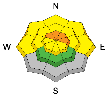
New snow accompanied by wind will add stress to buried weak layers in the snowpack. Today, there will be a very strong likelihood for human triggered, persistent slab avalanches, particularly on steep, northerly facing aspects right around treeline and above. Depending on how much snow we get, we may also see some natural activity in these areas. Stay off of, and out from under steep slopes today, and practice safe travel techniques.
|
 |
weather A deepening storm system will move through our area today and linger into tomorrow. This morning should see periods of heavy snow with 5-9" possible decreasing by this afternoon. We could see another 3-5" tonight. High temperatures at 10,000' will be around 15 degrees, and winds will be from the SW at 15- 20 mph gusting to 30. Showers may linger into Tuesday. Today Snow. High near 14. South southwest wind 5 to 15 mph. Chance of precipitation is 100%. Total daytime snow accumulation of 5 to 9 inches possible. Tonight Snow. Low around 1. West northwest wind around 5 mph. Chance of precipitation is 100%. New snow accumulation of 3 to 5 inches possible. Tuesday Snow. High near 7. Wind chill values as low as -10. North northwest wind 5 to 10 mph. Chance of precipitation is 80%. New snow accumulation of 3 to 5 inches possible. Tuesday Night A 50 percent chance of snow. Mostly cloudy, with a low around 0. Northwest wind around 5 mph. New snow accumulation of less than one inch possible. Wednesday Mostly sunny, with a high near 11. Northwest wind around 5 mph. |
| general announcements The Road to the Geyser Pass Trailhead will not be plowed today, and expect snow to pile up. Matt has been grooming over the weekend and I'm sure will be back at it after the storm. Thanks for sending in your observations. You can view Moab observations here. To post an observation go here. To receive this advisory by email go here. This information does not apply to developed ski areas or highways where avalanche control is normally done. This advisory is from the U.S.D.A. Forest Service, which is solely responsible for its content. This advisory describes general avalanche conditions and local variations always exist. |


