| Please join us at the 23rd annual Black Diamond Fall Fundraiser Party Thursday Sept 15. Tickets are on sale now here, at the Black Diamond store & at REI. Special bonus raffle for online ticket purchasers! |
| Please join us at the 23rd annual Black Diamond Fall Fundraiser Party Thursday Sept 15. Tickets are on sale now here, at the Black Diamond store & at REI. Special bonus raffle for online ticket purchasers! |
| Advisory: Moab Area Mountains | Issued by Eric Trenbeath for Friday - December 4, 2015 - 7:06am |
|---|

|
bottom line There remains an isolated or MODERATE danger for triggering a wind slab along the lee sides of upper elevation ridge crests and terrain features that face NW-N-NE-SE There also remains a very isolated, or MODERATE danger for triggering a persistent slab on slopes steeper than 35 degrees with a NW-N-E aspect right around tree line and above, in areas of rocky and radical terrain. Elsewhere the avalanche danger is generally LOW.
|
 |
current conditions Temperatures have actually been climbing since about 8:00 pm last night and it is currently a balmy 36 degrees at the Geyser Pass Trailhead, and 26 on Pre Laurel Peak. Winds down on Abajo Peak have shifted from light and westerly to more southerly, and are currently averaging 15-20 mph. I made a foray up into Gold Basin yesterday, and though it is still an early season, shallow snowpack with many obstacles lurking beneath the surface, I was amazed at how well off we are. The 8" of light, fluffy, low density snow we picked up last Sunday night has settled to about half that, but powder conditions remain quite good, especially at upper elevations and in sheltered areas. Warmer temperatures and a strong sun yesterday began to affect southerly aspects so expect to find them crusted over today. Base depth in Gold Basin: 33" Base depth at Geyser Pass Trailhead: 21" Winds, temperature and humidity on Pre-Laurel Peak New snow totals, temperature and humidity in Gold Basin Total snow depth and temperature at Geyser Pass Trailhead
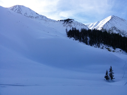
It's looking pretty white up there. Particularly in sheltered areas between 10,000 and 11,000 feet where a base of 3'-4' exists. Extreme upper elevations have seen a lot of wind so a lot of rocks are still exposed.
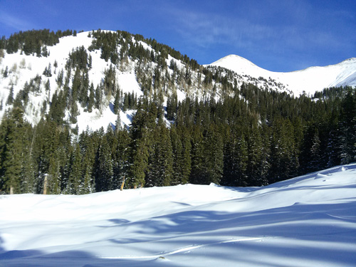
Even sun exposed slopes are holding decent snow. Note the humps of barely covered rocks in the foreground however. Still good to be cautious.
|
| type | aspect/elevation | characteristics |
|---|

|

|
LIKELIHOOD
 LIKELY
UNLIKELY
SIZE
 LARGE
SMALL
TREND
 INCREASING DANGER
SAME
DECREASING DANGER
|
|
description
Moderate westerly winds throughout the week have moved snow around in upper elevation, wind exposed areas, and yesterday I observed pockets of wind drifted snow on the lee sides of ridge crests, and terrain features. Though found primarily on slopes with an easterly component, you may find them creeping around on to slopes facing N-NW. Most have gained strength and I wasn't able to crack any out, but be on the lookout for characteristic, smooth, rounded pillows, especially if they have a hollow feel to them. |
| type | aspect/elevation | characteristics |
|---|

|
|
LIKELIHOOD
LIKELY
UNLIKELY
SIZE
 LARGE
SMALL
TREND
INCREASING DANGER
SAME
DECREASING DANGER
|
|
description
Depth hoar development has accelerated near the ground, and the snow pack is still harboring some weak layers, but stability tests show the pack to be mostly stable. It may still be possible to trigger a persistent slab avalanche in the usual suspect areas - steep, rocky slopes that face the north half of the compass, right around and above treeline, and these areas should always be approached with caution, but in general, the identified weaknesses are more of a concern for future snow loads. |
 |
weather A weak, fast moving, and splitting system will spread a few clouds over our area today before high pressure builds for the weekend. High temperatures at 10,000' will be up in the high 30's. Today Partly sunny, with a high near 43. North wind 5 to 10 mph becoming south in the afternoon. Tonight Mostly cloudy, with a low around 24. South wind 5 to 10 mph becoming west after midnight. Saturday Sunny, with a high near 40. North northwest wind 5 to 10 mph. Saturday Night Mostly clear, with a low around 19. North northeast wind around 5 mph becoming calm in the evening. Sunday Sunny, with a high near 41. South wind around 5 mph.
|
| general announcements The Road to the Geyser Pass Trailhead is plowed but snowpacked. Thanks for sending in your observations. You can view Moab observations here. To post an observation go here. To receive this advisory by email go here. This information does not apply to developed ski areas or highways where avalanche control is normally done. This advisory is from the U.S.D.A. Forest Service, which is solely responsible for its content. This advisory describes general avalanche conditions and local variations always exist. |