| Please join us at the 23rd annual Black Diamond Fall Fundraiser Party Thursday Sept 15. Tickets are on sale now here, at the Black Diamond store & at REI. Special bonus raffle for online ticket purchasers! |
| Please join us at the 23rd annual Black Diamond Fall Fundraiser Party Thursday Sept 15. Tickets are on sale now here, at the Black Diamond store & at REI. Special bonus raffle for online ticket purchasers! |
| Advisory: Moab Area Mountains | Issued by Eric Trenbeath for Friday - November 27, 2015 - 7:28am |
|---|

|
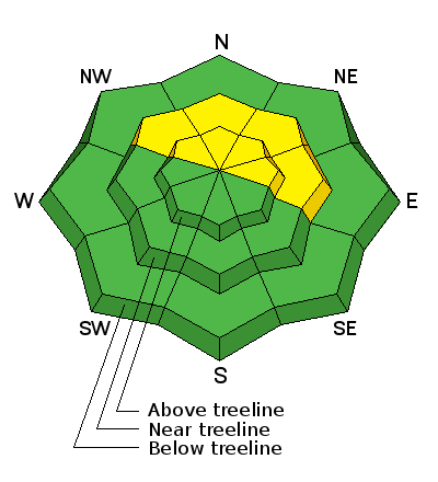
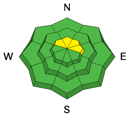
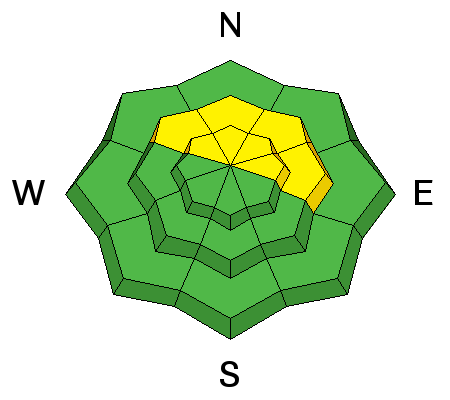
bottom line There is an isolated or MODERATE danger for triggering a stiff wind slab primarily in steep, north facing terrain underneath cliff bands or on the lees sides of terrain features well below ridge crests. There also remains an isolated, or MODERATE danger for triggering a persistent slab on slopes steeper than 35 degrees with a NW-N-E aspect. This danger is most likely in areas of rocky and more radical terrain, where a stiff slab overlies underlying weak layers. Elsewhere the avalanche danger is generally LOW.
|
 |
current conditions Trace amounts of snow fell in the mountains yesterday, and the winds of mid-week have tapered off a bit. Pre Laurel winds are unavailable until we get another part next week, but down on Abajo Peak, they blew overnight in the teens with gusts to 25 mph from the SSE. Temperatures have been steadily dropping overnight and it is currently a frigid 9 degrees on Pre Laurel, and 16 in Gold Basin. In general, the snow surface is pretty worked over from the effects of wind, sun and warm temperatures. Settled powder conditions can still be found in sheltered areas but remember that it is still a shallow, early season snow pack and many obstacles such as stumps, rocks, and dead fall lurk beneath the surface. Base depth in Gold Basin: 29" Base depth at Geyser Pass Trailhead: 19" Winds, temperature and humidity on Pre-Laurel Peak New snow totals, temperature and humidity in Gold Basin Total snow depth and temperature at Geyser Pass Trailhead
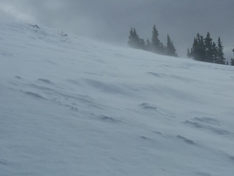
Winds on Wednesday.
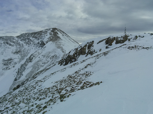
Scoured ridge on the way to Pre Laurel Peak.
|
| type | aspect/elevation | characteristics |
|---|

|
|
LIKELIHOOD
 LIKELY
UNLIKELY
SIZE
 LARGE
SMALL
TREND
 INCREASING DANGER
SAME
DECREASING DANGER
|
|
description
Stiff, shallow, isolated wind slabs exist in exposed locations on the lee sides of terrain features. Difficult to trigger or even crack out, most are quite small and won't pose much of a problem. Areas of greater concern are on upper elevation, northerly aspects, down slope, well below the ridge crests and beneath rock bands where eddying wind currents have allowed more snow to be deposited. |
| type | aspect/elevation | characteristics |
|---|

|
|
LIKELIHOOD
LIKELY
UNLIKELY
SIZE
 LARGE
SMALL
TREND
 INCREASING DANGER
SAME
DECREASING DANGER
|
|
description
The danger for persistent slab avalanches is more a future concern at this time due to the development of persistent weak layers in the snowpack and the game now is to wait for a new snow load. Nevertheless, snow from the Nov. 10-11 storm, has consolidated into a cohesive layer on top of these weak layers, and it may still be possible to trigger an avalanche on slopes steeper than 35 degrees with a northerly aspect. |
 |
weather Today A 30 percent chance of snow, mainly after 2pm. Partly sunny, with a high near 39. Northeast wind 5 to 10 mph becoming southwest in the afternoon. Tonight A 50 percent chance of snow. Mostly cloudy, with a low around 25. South southwest wind 5 to 10 mph. New snow accumulation of 1 to 3 inches possible. Saturday A 40 percent chance of snow. Partly sunny, with a high near 38. South southwest wind 5 to 10 mph. Saturday Night A 10 percent chance of snow. Mostly cloudy, with a low around 22. Southwest wind around 5 mph. Sunday A 20 percent chance of snow. Mostly cloudy, with a high near 36. South southwest wind around 5 mph becoming west in the afternoon. |
| general announcements The Road to the Geyser Pass Trailhead is plowed but with patches of mud, ice and packed snow. Thanks for sending in your observations. You can view Moab observations here. To post an observation go here. To receive this advisory by email go here. This information does not apply to developed ski areas or highways where avalanche control is normally done. This advisory is from the U.S.D.A. Forest Service, which is solely responsible for its content. This advisory describes general avalanche conditions and local variations always exist. |