| Please join us at the 23rd annual Black Diamond Fall Fundraiser Party Thursday Sept 15. Tickets are on sale now here, at the Black Diamond store & at REI. Special bonus raffle for online ticket purchasers! |
| Please join us at the 23rd annual Black Diamond Fall Fundraiser Party Thursday Sept 15. Tickets are on sale now here, at the Black Diamond store & at REI. Special bonus raffle for online ticket purchasers! |
| Advisory: Moab Area Mountains | Issued by Eric Trenbeath for Friday - November 20, 2015 - 6:59am |
|---|

|
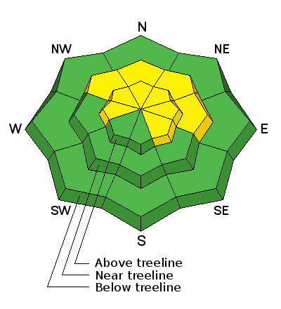
bottom line The danger remains MODERATE for triggering a persistent slab on slopes steeper than 35 degrees with a NW-N-E aspect. There is also a MODERATE or isolated danger for triggering a stiff wind slab on slopes steeper than 35 degrees in wind exposed terrain.
|
 |
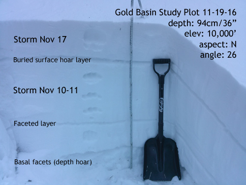
current conditions The mountains picked up 6"-8" of new snow from Tuesday's storm event, but wind and warm temperatures have taken a bit of a toll on the snow surface. Snow yesterday was getting damp on sun exposed slopes so expect to find some crusts out there today. Good powder conditions can still be found in sheltered areas but remember that it is still a shallow, early season snow pack. Pre-Laurel Peak winds have been light and westerly overnight and they remain in the single digits this morning. It is currently 21 degrees up there and 31 at the Geyser Pass Trailhead. Base depth in Gold Basin: 34" Base depth at Geyser Pass Trailhead: 24" Winds, temperature and humidity on Pre-Laurel Peak New snow totals, temperature and humidity in Gold Basin Total snow depth and temperature at Geyser Pass Trailhead
|
| type | aspect/elevation | characteristics |
|---|

|
|
LIKELIHOOD
 LIKELY
UNLIKELY
SIZE
 LARGE
SMALL
TREND
 INCREASING DANGER
SAME
DECREASING DANGER
|
|
description
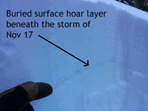
A few key, persistent weak layers exist in the snow pack at this time. Snow that fell earlier in the week is now sitting on top of a layer of surface hoar. Stability tests yesterday produced easy sheers in this weak layer that will become more problematic when we get more snow. Additionally, there is a mid-level layer of faceted snow as well as a few inches of depth hoar at the ground level. It may be possible to trigger a deeper persistent slab on one of these buried weak layers on slopes steeper than 35 degrees that have a NW-N-NE aspect, right around tree line and above. Backcountry riders should continue to approach these slopes with caution.
|
| type | aspect/elevation | characteristics |
|---|

|
|
LIKELIHOOD
LIKELY
UNLIKELY
SIZE
 LARGE
SMALL
TREND
 INCREASING DANGER
SAME
DECREASING DANGER
|
|
description
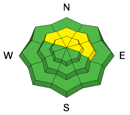
Stiff wind slabs exist in exposed terrain, primarily at upper elevations, on the lee sides of ridge crests and terrain features. They will be stubborn to move, but if triggered could take you for a ride over rocks and cliffs. Look for smooth rounded pillows of snow that have a chalky appearance or hollow feel to them. Avoid slopes steeper than 35 degrees where they are present. |
 |
weather Mostly sunny skies and warm temperatures are on tap through the weekend. Next chance fro precipitation is mid - next week though it isn't looking real promising for us at this time. Today Mostly sunny, with a high near 49. North wind 5 to 10 mph becoming northwest 10 to 15 mph in the afternoon. Tonight Mostly clear, with a low around 24. North northwest wind 5 to 10 mph becoming east northeast after midnight. Saturday Sunny, with a high near 39. East northeast wind around 5 mph becoming northwest in the morning. Saturday Night Mostly clear, with a low around 21. East wind around 5 mph. Sunday Sunny, with a high near 47. East wind around 5 mph becoming northwest in the morning. |
| general announcements This signals the start of the official season with advisories posted over the weekends with mid-week updates as conditions warrant. The Road to the Geyser Pass Trailhead is plowed but with patches of mud, ice and packed snow. Thanks for sending in your observations. You can view Moab observations here. To post an observation go here. To receive this advisory by email go here. This information does not apply to developed ski areas or highways where avalanche control is normally done. This advisory is from the U.S.D.A. Forest Service, which is solely responsible for its content. This advisory describes general avalanche conditions and local variations always exist. |