| Please join us at the 23rd annual Black Diamond Fall Fundraiser Party Thursday Sept 15. Tickets are on sale now here, at the Black Diamond store & at REI. Special bonus raffle for online ticket purchasers! |
| Please join us at the 23rd annual Black Diamond Fall Fundraiser Party Thursday Sept 15. Tickets are on sale now here, at the Black Diamond store & at REI. Special bonus raffle for online ticket purchasers! |
| Advisory: Moab Area Mountains | Issued by Eric Trenbeath for Monday - November 16, 2015 - 6:52am |
|---|

|
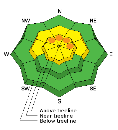
bottom line Overall, the avalanche danger is MODERATE today both for triggering a recently deposited wind slab, or a deeper persistent slab avalanche on slopes steeper than 35 degrees that have an E-N-NW aspect. If forecasted snow totals today come in on the upper end, the danger for newly deposited wind slabs will rise to CONSIDERABLE in exposed, upper elevation terrain that has an E-N-NW aspect.
|
 |
current conditions Snotel data is spotty this morning but as of 2:00 a.m. only an inch of snow had fallen at Geyser Pass Trailhead. Southeasterly ridge top winds averaged 22 mph with gusts into the low 40's between 8:00 p.m. and 12:00 a.m. They have since backed off into the single digits with gusts to 20 mph. It is currently 12 degrees on Pre Laurel Peak and 19 in Gold Basin. We are getting clipped by this storm system with the bulk of it hitting Colorado, and there is already some clearing over the mountains this morning. I expect the forecasted snow totals of 4" - 8" today will come in on the lower end. Nevertheless, snowy and occasionally blustery conditions are forecasted for the mountains today. Base depth at Geyser Pass Trailhead: 22" Base depth in Gold Basin: 32"
|
| type | aspect/elevation | characteristics |
|---|

|
|
LIKELIHOOD
 LIKELY
UNLIKELY
SIZE
 LARGE
SMALL
TREND
 INCREASING DANGER
SAME
DECREASING DANGER
|
|
description
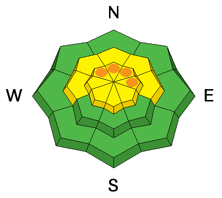
Today your primary concern will be recent deposits of wind drifted snow. The overall depth and extent of these wind slabs will be determined by how much snow we get, and how much it gets blown around. Be alert for new drifts that have a characteristic smooth, rounded appearance, and watch for signs of instability such as collapsing or cracking in the snow. Wind slab danger could rise to CONSIDERABLE today in exposed, upper elevation terrain, steeper than 35 degrees that has a NW-N-E aspect. |
| type | aspect/elevation | characteristics |
|---|

|
|
LIKELIHOOD
LIKELY
UNLIKELY
SIZE
 LARGE
SMALL
TREND
 INCREASING DANGER
SAME
DECREASING DANGER
|
|
description
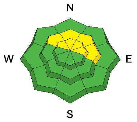
I don't expect snow totals today to increase the danger for persistent slab avalanches, but there remains a MODERATE danger for triggering a slide down on to a buried weak layer that formed prior to last week's storm. This danger would most likely be found on mid to upper elevation slopes, steeper than 35 degrees that have an E-N-NW aspect. |
 |
weather National Weather Service has issued a Winter Storm Warning through 8:00 a.m. tomorrow morning with 4-8" possible today and another 3-5" tonight. However, the bulk of this system has centered over Colorado and we are just on the western edge of the moisture. Some mountain clearing is already occurring this morning though we may see another impulse after noon. High temperatures today at 10,000' will be in the low to mid 20's and south winds this morning will average 15-20 mph with gusts as high as 50. Winds will shift to NW this afternoon which I fear may leave us with an all "huff and not much puff," situation. Today Snow before 11am, then snow showers between 11am and 5pm, then snow after 5pm. Areas of blowing snow before 3pm. High near 24. Breezy, with a south wind 15 to 25 mph becoming northwest in the afternoon. Winds could gust as high as 50 mph. Chance of precipitation is 90%. Total daytime snow accumulation of 4 to 8 inches possible. Tonight Snow, mainly before midnight. Areas of blowing snow after 7pm. Low around 14. Very windy, with a north wind 20 to 30 mph increasing to 30 to 40 mph in the evening. Winds could gust as high as 55 mph. Chance of precipitation is 80%. New snow accumulation of 3 to 5 inches possible. Tuesday A 20 percent chance of snow. Partly sunny, with a high near 22. Windy, with a north wind around 30 mph, with gusts as high as 45 mph. Tuesday Night A 10 percent chance of snow before 11pm. Partly cloudy, with a low around 16. Blustery, with a northwest wind 15 to 20 mph. Wednesday Mostly sunny, with a high near 27. West northwest wind around 15 mph, with gusts as high as 25 mph. |
| general announcements This signals the start of the official season with advisories posted over the weekends with mid-week updates as conditions warrant. The Road to the Geyser Pass Trailhead is plowed but with patches of ice and packed snow. Thanks for sending in your observations. You can view Moab observations here. To post an observation go here. To receive this advisory by email go here. This information does not apply to developed ski areas or highways where avalanche control is normally done. This advisory is from the U.S.D.A. Forest Service, which is solely responsible for its content. This advisory describes general avalanche conditions and local variations always exist. |


