| During the month of April, Mark Miller will donate $75 to the charity of your choice (5 to chose from, including the Utah Avalanche Center!) Mark Miller Subaru has raised over $300k in the previous 6 Do Good Feel Good events. More Info here |  |
| During the month of April, Mark Miller will donate $75 to the charity of your choice (5 to chose from, including the Utah Avalanche Center!) Mark Miller Subaru has raised over $300k in the previous 6 Do Good Feel Good events. More Info here | |
| Advisory: Moab Area Mountains | Issued by Eric Trenbeath for Monday - March 23, 2015 - 7:15am |
|---|


|
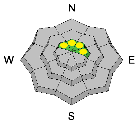
bottom line Timing is everything this time of year. The avalanche danger is generally LOW in the morning but will rise to MODERATE as daytime heating increases the danger for wet slide activity on all aspects. There also still remains an isolated danger for triggering a dry persistent slab. Though "pockety" in nature, this danger may exist on steep, rocky terrain, right around tree line and above on slopes that have a NW-N-E aspect.
|
 |
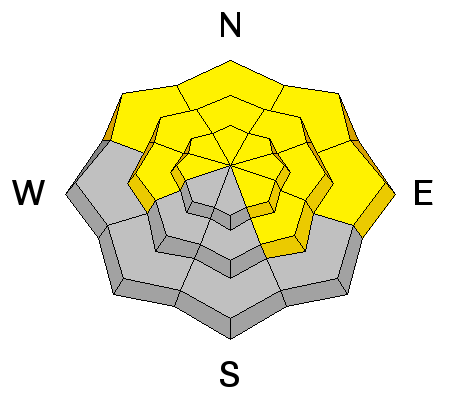
special announcement With spring conditions in full effect, this advisory will be updated on Monday and Friday barring a significant change in the weather and or avalanche conditions. Conditions are generally predictable at this time with daytime heating increasing the danger for wet slide activity. Timing is everything and it is important to be off of steep slopes as they become wet and sloppy.The presence of an overnight freeze helps to stabilize conditions each day. The lack of a re-freeze constitutes a trend of continued instability. Check the weather links under current conditions for current and overnight temperatures. |
 |
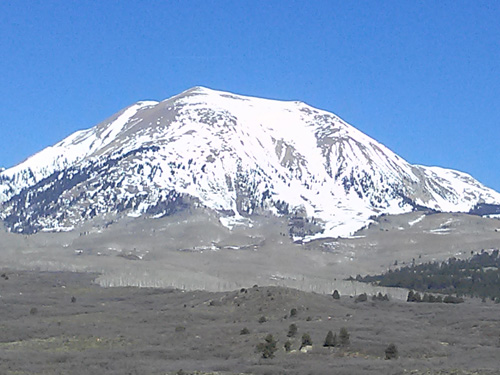
current conditions La Sal Mountains Spring conditions remain in effect and the mountains look about 6 weeks ahead of schedule for melting out. We've had solid refreezes for many nights creating perfect corn conditions on SE through SW aspects. The difficulty comes in finding one of these slopes that still has snow on them. A trip over to the SE face of Mount Peale on Sunday proved to be exceptionally rewarding, but many adjacent slopes were bare. Extreme, upper elevation north facing slopes are still harboring some dry snow while just below they are turning into a transitional snow pack with a melt freeze crust on top, and moist facets underneath.
3000' of good corn snow still remains on the SE Face of Mount Peale.
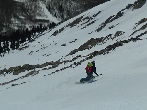
Local observer Evan Clapper investigates the quality of the corn snow.
Tuklear Reaction, the prominent gully off the summit of Mount Tukunikivatz is looking very thin.
Upper elevation north faces are still hanging in there.
La Sal Weather Data Wind speeds and temperature at 11,700' on Pre-Laurel Peak. New snow totals and temperature at Geyser Pass Trailhead. New snow totals and temperature in Gold Basin. Abajo / Blue Mountains Spring conditions and overall low coverage remain the order in the Abajos. Abajo / Blue Mountains Current Weather Winds and temperature on Abajo Peak. Snow total at Buckboard Flat.
|
 |
recent activity
|
| type | aspect/elevation | characteristics |
|---|

|
|
LIKELIHOOD
 LIKELY
UNLIKELY
SIZE
 LARGE
SMALL
TREND
 INCREASING DANGER
SAME
DECREASING DANGER
|
|
description
We haven't seen the results of neighboring ranges, either for loose wet avalanches or wet slab releases. Small point releases and the occasional loose sluff on sun exposed slopes has been the extent of it. Continued overnight freezes have locked the snow back in place on a daily basis. Nevertheless, timing is everything this time of year and you need to pay attention to a rising danger for wet slide activity on all aspects as the day heats up. Even upper elevation north facing slopes may start to be affected. Stay off of and out from under steep slopes if you notice the snow getting sloppy or see signs of instability such as pinwheels, roller balls, or loose snow sluffs.
|
| type | aspect/elevation | characteristics |
|---|

|
|
LIKELIHOOD
 LIKELY
UNLIKELY
SIZE
LARGE
SMALL
TREND
 INCREASING DANGER
SAME
DECREASING DANGER
|
|
description
The danger for triggering a persistent slab has greatly diminished, and people have been pushing into much larger terrain than is typical for the La Sals without incident. The danger now is very isolated and "pockety" but it does still exist in areas of steep, rocky terrain right around tree line or just above on slopes with a NW-N-E aspect. |
 |
weather A weak cold front will move through our area on Monday and Tuesday bringing with it, occasional periods of cloudiness and a slight chance of snow showers. Blustery conditions will exist with moderate SW winds on Monday shifting to NW Tuesday into Wednesday. Conditions again dry out later in the week. Monday A slight chance of rain and snow showers between 2pm and 4pm, then a slight chance of snow showers after 4pm. Mostly sunny, with a high near 42. Breezy, with a southwest wind 15 to 25 mph, with gusts as high as 40 mph. Chance of precipitation is 20%. Monday night Scattered snow showers, mainly between 2am and 5am. Mostly cloudy, with a low around 21. Windy, with a northwest wind 25 to 30 mph, with gusts as high as 50 mph. Chance of precipitation is 40%. Tuesday Mostly sunny, with a high near 36. Breezy, with a west wind 15 to 20 mph, with gusts as high as 35 mph. Tuesday Night Mostly cloudy, with a low around 25. Breezy, with a northwest wind 15 to 20 mph, with gusts as high as 30 mph. Wednesday Mostly sunny, with a high near 38. Breezy, with a north northwest wind 15 to 20 mph. Wednesday Night Partly cloudy, with a low around 17. Thursday Mostly sunny, with a high near 38. Thursday Night Partly cloudy, with a low around 23. |
| general announcements Observations: If you are out and about, I would love to know what you are seeing. Please post your observations here. EMAIL ADVISORY If you would like to get the daily advisory by email you will need to subscribe here. Benefit the Utah Avalanche Center when you shop from Backcountry.com or REI: Click this link for Backcountry.com or this link to REI, shop, and they will donate a percent of your purchase price to the UAC. Both offer free shipping (with some conditions) so this costs you nothing! Benefit the Utah Avalanche Center when you buy or sell on ebay - set the Utah Avalanche Center as a favorite non-profit in your ebay account here and click on ebay gives when you buy or sell. You can choose to have your seller fees donated to the UAC, which doesn't cost you a penny. This advisory is from the U.S.D.A. Forest Service, which is solely responsible for its content. This advisory describes general avalanche conditions and local variations always exist. |


_2.jpg)