| During the month of April, Mark Miller will donate $75 to the charity of your choice (5 to chose from, including the Utah Avalanche Center!) Mark Miller Subaru has raised over $300k in the previous 6 Do Good Feel Good events. More Info here |  |
| During the month of April, Mark Miller will donate $75 to the charity of your choice (5 to chose from, including the Utah Avalanche Center!) Mark Miller Subaru has raised over $300k in the previous 6 Do Good Feel Good events. More Info here | |
| Advisory: Moab Area Mountains | Issued by Eric Trenbeath for Saturday - March 7, 2015 - 7:14am |
|---|

|
bottom line The avalanche danger is a very solid MODERATE today trending more toward the high end where pockets of CONSIDERABLE danger remain for triggering a deep and dangerous persistent slab. This danger is most prevalent on steep rocky terrain, right around tree line and above on slopes that have a NW-N-E aspect. There is also a MODERATE danger for wet slide activity on sun exposed slopes as the day heats up.
|
 |
current conditions La Sal Mountains Things have gone from winter to spring overnight. The 25"-30" of snow we received over the pasty week has settled, and sun crusts have formed on exposed aspects. Excellent settled powder conditions can be found on sheltered, northerly aspects. Mashed potato conditions will develop in the sun as the day heats up. Don't forget your skin wax to avoid the dreaded glop build up as you transition from dry snow in the shade to wet snow in the sun. Winds last night and this morning are basically non-existent. Temps are in the mid 20's this morning. La Sal Mountains Current Weather Wind speeds and temperature at 11,700' on Pre-Laurel Peak. New snow totals and temperature at Geyser Pass Trailhead. New snow totals and temperature in Gold Basin. Abajo / Blue Mountains The Abajos picked up about half as much snow from this storm series and totals are around 15" since last Friday. Snow cover in the range is still very thin. "Spatial variability" is the key term. This means you can find snow up to four feet deep on on a sheltered, northerly aspect while a more exposed, adjacent slope will still be showing rocks and grass. Abajo / Blue Mountains Current Weather Winds and temperature on Abajo Peak. Snow total at Buckboard Flat.
|
 |
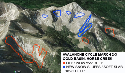
recent activity Brian Murdock and I had a good look around in Gold Basin on Wednesday and saw the remains of a significant avalanche cycle. The strong SW winds and heavy snows on Monday produced numerous natural avalanches, mostly all on N-NE aspects right around tree line and above. Several of these involved old, deeper snow, (persistent slabs) and one slide in Horse Creek was up to 5' deep. The cycle continued through Tuesday when additional snow sluffed off or released as soft slab / new snow avalanches between 18" and 3' deep.
Note the distribution of deep, persistent slabs right around tree line.
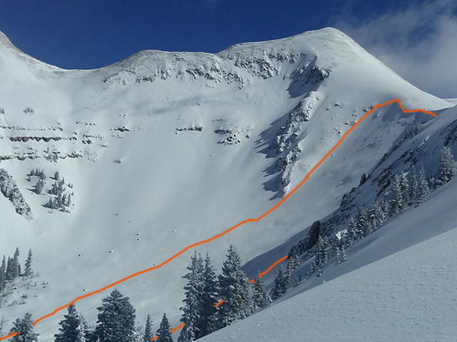
This deep, persistent slab at the head of Horse Creek was 5' deep, approximately 200' wide and ran for over 1000'.
|
| type | aspect/elevation | characteristics |
|---|

|

|
LIKELIHOOD
 LIKELY
UNLIKELY
SIZE
 LARGE
SMALL
TREND
 INCREASING DANGER
SAME
DECREASING DANGER
|
|
description
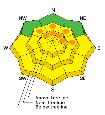
The danger for triggering a persistent slab is still alive and well though being able to predict exactly where and when will be a little bit like rolling the dice. One suspect slope may not move, while one next to it may. One thing is for sure. Once triggered, a slide of this type will be large and dangerous.This danger is most prevalent right around, and just above tree line on steep rocky slopes that face the north half of the compass. This type of terrain is best avoided for awhile. Check out this video on persistent slabs from Trent Meisenheimer at the UAC up in SLC.
|
| type | aspect/elevation | characteristics |
|---|

|

|
LIKELIHOOD
 LIKELY
UNLIKELY
SIZE
 LARGE
SMALL
TREND
INCREASING DANGER
SAME
DECREASING DANGER
|
|
description
The loose new snow earlier in the week has now been locked up by a couple of melt-freeze periods during the week which has made it less reactive. Nevertheless, a strong March sun still has the potential to turn sun exposed slopes into mashed potatoes so be alert to signs of unstable wet snow as the day heats up. Point releases, pinwheels, and wet sloppy snow are all signs of instability so stay off of and out from under steep slopes if these signs are present. |
 |
weather Another sunny day is in store for the mountains with high temperatures at 10,000' to be in the mid to upper 30's. Winds will be light and easterly. A few high clouds will move in later today and tonight as a weak disturbance brushes by to the north. Sunday looks to be mostly sunny and a bit cooler. |
| general announcements Road Conditions: The road was not yet been plowed. Observations: If you are out and about, I would love to know what you are seeing. Please post your observations here. EMAIL ADVISORY If you would like to get the daily advisory by email you will need to subscribe here. Benefit the Utah Avalanche Center when you shop from Backcountry.com or REI: Click this link for Backcountry.com or this link to REI, shop, and they will donate a percent of your purchase price to the UAC. Both offer free shipping (with some conditions) so this costs you nothing! Benefit the Utah Avalanche Center when you buy or sell on ebay - set the Utah Avalanche Center as a favorite non-profit in your ebay account here and click on ebay gives when you buy or sell. You can choose to have your seller fees donated to the UAC, which doesn't cost you a penny. This advisory is from the U.S.D.A. Forest Service, which is solely responsible for its content. This advisory describes general avalanche conditions and local variations always exist. |


_2.jpg)