
| During the month of April, Mark Miller will donate $75 to the charity of your choice (5 to chose from, including the Utah Avalanche Center!) Mark Miller Subaru has raised over $300k in the previous 6 Do Good Feel Good events. More Info here |  |
| During the month of April, Mark Miller will donate $75 to the charity of your choice (5 to chose from, including the Utah Avalanche Center!) Mark Miller Subaru has raised over $300k in the previous 6 Do Good Feel Good events. More Info here | |
| Advisory: Moab Area Mountains | Issued by Eric Trenbeath for Sunday - March 1, 2015 - 6:56am |
|---|

|
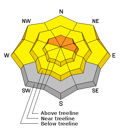
bottom line Areas of CONSIDERABLE avalanche danger exist, primarily in wind affected terrain on slopes steeper than about 35 degrees that have a NW-N-E aspect. Beware of smooth rounded deposits of wind drifted snow and pay attention to signs of instability such as cracking or collapsing in the snowpack. Out of the wind zone, the avalanche danger is generally MODERATE. There is also a MODERATE danger for triggering a buried persistent slab on steep, rocky, north facing terrain, especially right around tree line.
|
 |
current conditions La Sal Mountains Another 5" of snow has fallen bringing us up to 10" since Thursday. Though not measuring up to forecasted amounts, conditions are steadily improving. The difference with this latest round of snow has been southerly winds which averaged 20 mph yesterday along ridge tops with gusts into the 40's. For this reason you will want to seek out more sheltered terrain, both for better quality turning and for safety sake. Winds have been on the decrease overnight and are currently in the 10-15 mph range from the SW. It is currently 23 degrees at the Geyser Pass trailhead. La Sal Mountains Current Weather Wind speeds and temperature at 11,700' on Pre-Laurel Peak. New snow totals and temperature at Geyser Pass Trailhead. New snow totals and temperature in Gold Basin. Abajo / Blue Mountains The Abajos picked up 6" overnight but snow cover in the range is still very thin. "Spatial variability" is the key term. This means you can find snow up to four feet deep on on a sheltered, northerly aspect while a more exposed, adjacent slope will still be showing rocks and grass. Winds during the week have moved snow around and even stripped it away on many slopes that were bare prior to last week's storm. You will need to seek out sheltered, northerly aspects to find good powder conditions over a reasonable base. Abajo / Blue Mountains Current Weather Winds and temperature on Abajo Peak. Snow total at Buckboard Flat.
|
 |
recent activity
|
| type | aspect/elevation | characteristics |
|---|

|
|
LIKELIHOOD
 LIKELY
UNLIKELY
SIZE
 LARGE
SMALL
TREND
 INCREASING DANGER
SAME
DECREASING DANGER
|
|
description
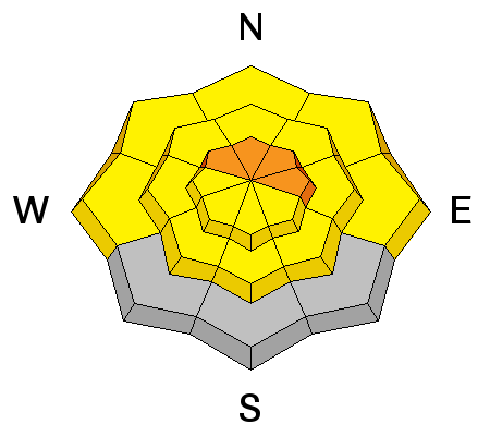
Today, expect to find newly deposited wind slabs along the lee sides of ridge crests and terrain features, primarily in wind affected, upper elevation terrain steeper than about 35 degrees that has a NW-N-E aspect. With winds on the decrease, I don't expect natural activity today, but these slabs will be sensitive to the weight of a skier or rider, and it will be important to pay attention to the consequences of a taking a ride. Be on the lookout for smooth, rounded pillows of recently deposited, wind drifted snow and pay attention to signs of instability such as cracking in the snow surface and collapsing in the snowpack. |
| type | aspect/elevation | characteristics |
|---|

|
|
LIKELIHOOD
LIKELY
UNLIKELY
SIZE
LARGE
SMALL
TREND
INCREASING DANGER
SAME
DECREASING DANGER
|
|
description
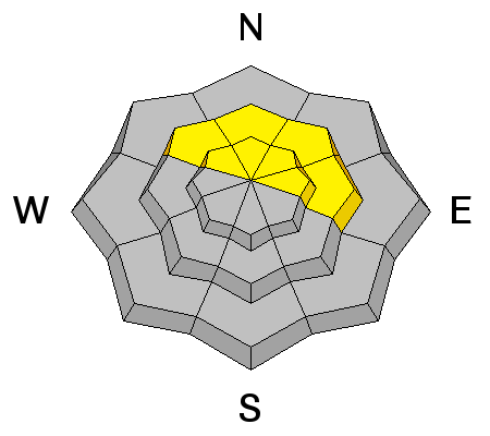
Weak, sugary, faceted snow is still abundant on shady aspects, particularly in steep, rocky terrain right around and just above tree line. We have enjoyed a period of relative stability where it was possible to go just about anywhere, but now it is time to start giving a wider birth to steep, north facing, avalanche terrain where the potential for triggering a buried persistent slab, though not widespread, is again becoming a concern. |
 |
weather This complicated and disorganized storm system continues to churn over the greater 4 Corners region delivering widely varying amounts of snow to different areas. Look for a bit of a lull today with scattered snow showers and perhaps a couple of inches possible. High temps will be in the mid to upper 20's and winds will be southwesterly at 10-15 mph. More snow is on the way tonight and by Monday, an upper level trough and associated Pacific moisture will bring us another shot at significant snow lasting into Tuesday. Things look to be drying out mid week. |
| general announcements Road Conditions: The road will not be plowed this morning. Observations: If you are out and about, I would love to know what you are seeing. Please post your observations here. EMAIL ADVISORY If you would like to get the daily advisory by email you will need to subscribe here. Benefit the Utah Avalanche Center when you shop from Backcountry.com or REI: Click this link for Backcountry.com or this link to REI, shop, and they will donate a percent of your purchase price to the UAC. Both offer free shipping (with some conditions) so this costs you nothing! Benefit the Utah Avalanche Center when you buy or sell on ebay - set the Utah Avalanche Center as a favorite non-profit in your ebay account here and click on ebay gives when you buy or sell. You can choose to have your seller fees donated to the UAC, which doesn't cost you a penny. This advisory is from the U.S.D.A. Forest Service, which is solely responsible for its content. This advisory describes general avalanche conditions and local variations always exist. |


_2.jpg)