| During the month of April, Mark Miller will donate $75 to the charity of your choice (5 to chose from, including the Utah Avalanche Center!) Mark Miller Subaru has raised over $300k in the previous 6 Do Good Feel Good events. More Info here |  |
| During the month of April, Mark Miller will donate $75 to the charity of your choice (5 to chose from, including the Utah Avalanche Center!) Mark Miller Subaru has raised over $300k in the previous 6 Do Good Feel Good events. More Info here | |
| Advisory: Moab Area Mountains | Issued by Eric Trenbeath for Thursday - February 19, 2015 - 7:15am |
|---|


|
bottom line The avalanche danger is generally LOW at this time but low danger doesn't mean no danger. With daytime heating the potential for wet slide activity exists on sun exposed slopes. There also remains an isolated possibility for triggering a buried persistent slab on steep shady aspects in more extreme upper elevation terrain, particularly in rocky areas that have a thin shallow snowpack.
|
 |
current conditions
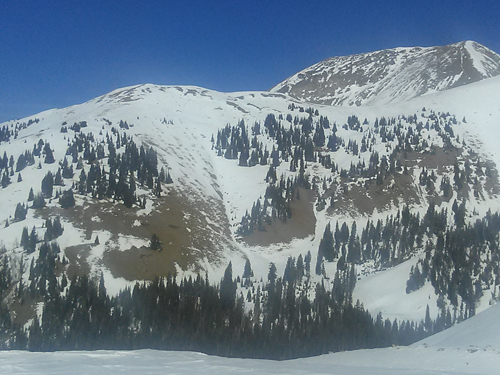
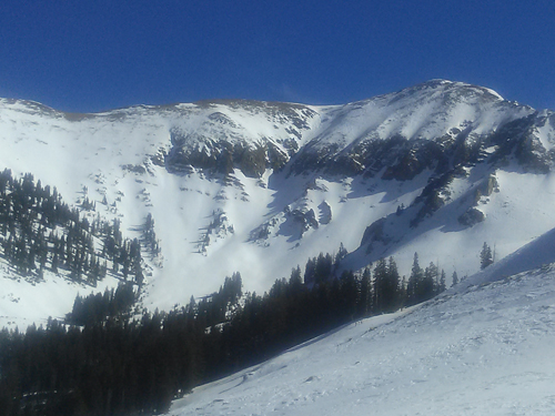
Today will be your last day for corn snow as a series of weak storm systems are lined up to affect our area over the weekend. You will have to choose your line carefully as sun exposed slopes are getting thin and many are melted out to the ground. Elsewhere, expect to find a variety of crusted surface conditions with only occasional pockets of soft, powder-like snow in extremely sheltered areas. Skies are mostly clear this morning and winds are light and westerly. Overnight lows dipped into the mid 20's on Pre Laurel Peak.
Southwest side of the range. Tuklear Reaction is the prominent gully off of Mount Tukunikivatz. Starting zone is completely void of snow and the bottom of the line is melted out also.
The SE face of Mount Peale to the right, melted out as if it were May. The south slopes are dry ground.
Bare south facing slopes above 11,000'
North faces hanging in there but the snow isn't exactly soft. La Sal Mountains Current Weather Wind speeds and temperature at 11,700' on Pre-Laurel Peak. New snow totals and temperature at Geyser Pass Trailhead. New snow totals and temperature in Gold Basin. Abajo / Blue Mountains. Low snow conditions continue to plague the Abajo Mountains. Winds and temperature on Abajo Peak. Snow total at Buckboard Flat.
|
 |
recent activity
|
| type | aspect/elevation | characteristics |
|---|

|
|
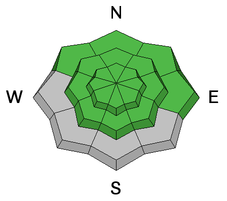
LIKELIHOOD
 LIKELY
UNLIKELY
SIZE
 LARGE
SMALL
TREND
 INCREASING DANGER
SAME
DECREASING DANGER
|
|
description
The avalanche danger is generally low at this time but as always, maintaining awareness of current and changing conditions is paramount for safety in the mountains and here are a couple of things to remain aware of. Wet slides: Continued warm temperatures and sunny skies mean it will be important to remain on the lookout for sloppy snow conditions on sunny aspects. If signs of instability such as sloppy wet snow, pinwheels, or wet point releases present themselves, it means it is time to stay off of and out from under steep, sun exposed slopes. Persistent Slab: In general we have reached a point where conditions are "weak but stable" and the chances of triggering a persistent slab are unlikely. Nevertheless, there still may be isolated areas where it is possible to trigger a persistent slab. Areas where you may find this problem are on upper-mid to upper elevation slopes steeper than 35 degrees that have a NW-N-E aspect, particularly in areas of rocky terrain that have a thin shallow snowpack. |
 |
weather Today look for mostly sunny skies with high temperatures in the mid 40's at 10,000'. Winds will be mostly light and westerly increasing later in the day. On Friday, the first in a series of storm systems, lacking in moisture, will begin to affect our area. Friday: A slight chance of rain and snow showers before noon, then a chance of snow showers. Partly sunny, with a high near 40. Breezy, with a west wind 15 to 20 mph. Chance of precipitation is 30%. |
| general announcements
EMAIL ADVISORY If you would like to get the daily advisory by email you will need to subscribe here. Benefit the Utah Avalanche Center when you shop from Backcountry.com or REI: Click this link for Backcountry.com or this link to REI, shop, and they will donate a percent of your purchase price to the UAC. Both offer free shipping (with some conditions) so this costs you nothing! Benefit the Utah Avalanche Center when you buy or sell on ebay - set the Utah Avalanche Center as a favorite non-profit in your ebay account here and click on ebay gives when you buy or sell. You can choose to have your seller fees donated to the UAC, which doesn't cost you a penny. This advisory is from the U.S.D.A. Forest Service, which is solely responsible for its content. This advisory describes general avalanche conditions and local variations always exist. This advisory will be updated on Thursday, January 22. |


_2.jpg)