
| During the month of April, Mark Miller will donate $75 to the charity of your choice (5 to chose from, including the Utah Avalanche Center!) Mark Miller Subaru has raised over $300k in the previous 6 Do Good Feel Good events. More Info here |  |
| During the month of April, Mark Miller will donate $75 to the charity of your choice (5 to chose from, including the Utah Avalanche Center!) Mark Miller Subaru has raised over $300k in the previous 6 Do Good Feel Good events. More Info here | |
| Advisory: Moab Area Mountains | Issued by Eric Trenbeath for Saturday - January 31, 2015 - 6:28am |
|---|


|
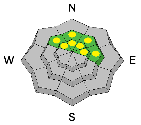
bottom line There is an isolated or MODERATE danger for triggering new, recently deposited wind slabs at upper elevations on the lee sides of ridge crests and terrain features. And though diminishing, there still remains an isolated or MODERATE danger for triggering a persistent slab in upper elevation areas of steep, rocky, and radical terrain that has a NW-N-E aspect. Elsewhere the avalanche danger is generally LOW.
|
 |
current conditions Well this storm certainly fizzled leaving only 2-3" of new snow in most areas. The dusting has freshened things up somewhat, primarily in areas where the underlying snow surface was relatively smooth, but we are still a long way from optimal winter conditions. SE winds blew yesterday during the "storm" in the 20-30 mph range along ridge tops. This morning they have backed off into the single digits. It is currently 18 degrees on Pre Laurel Peak and 27 at the Geyser Pass Trailhead. La Sal Mountains Current Weather Wind speeds and temperature at 11,700' on Pre-Laurel Peak. New snow totals and temperature at Geyser Pass Trailhead. New snow totals and temperature in Gold Basin. Abajo / Blue Mountains. Winds and temperature on Abajo Peak. Snow total at Buckboard Flat.
|
 |
recent activity
|
| type | aspect/elevation | characteristics |
|---|

|
|
LIKELIHOOD
 LIKELY
UNLIKELY
SIZE
 LARGE
SMALL
TREND
 INCREASING DANGER
SAME
DECREASING DANGER
|
|
description
The low snow totals in the end have not done much to increase the avalanche danger. You may find some shallow, sensitive wind drifts at upper elevations in wind exposed terrain on the lee sides of ridge crests and terrain features. |
| type | aspect/elevation | characteristics |
|---|

|
|
LIKELIHOOD
LIKELY
UNLIKELY
SIZE
 LARGE
SMALL
TREND
INCREASING DANGER
SAME
DECREASING DANGER
|
|
description
The new dusting of snow has not added significant weight to our fragile snowpack. In general we have reached a point where conditions are "weak but stable" and the chances of triggering a persistent slab are becoming unlikely. Nevertheless, there still may be isolated areas where it is possible to trigger a persistent slab.This danger is most pronounced on upper-mid to upper elevation slopes steeper than 35 degrees that have a NW-N-E aspect, particularly in areas of rocky terrain that have a thin shallow snowpack. |
 |
weather What's left of the storm will slide out today with occasional lingering showers into the afternoon. WSW winds at 10-15 mph will shift to northerly as the storm exits our area. High temps at 10,000' will be right around freezing. A ridge builds on Sunday bringing sunny skies ahead of an unsettled NW flow early next week. |
| general announcements
Grooming Conditions: Trails are scheduled to be groomed on Monday and Friday. Observations: If you are out and about, I would love to know what you are seeing. Please post your observations here. EMAIL ADVISORY If you would like to get the daily advisory by email you will need to subscribe here. Benefit the Utah Avalanche Center when you shop from Backcountry.com or REI: Click this link for Backcountry.com or this link to REI, shop, and they will donate a percent of your purchase price to the UAC. Both offer free shipping (with some conditions) so this costs you nothing! Benefit the Utah Avalanche Center when you buy or sell on ebay - set the Utah Avalanche Center as a favorite non-profit in your ebay account here and click on ebay gives when you buy or sell. You can choose to have your seller fees donated to the UAC, which doesn't cost you a penny. This advisory is from the U.S.D.A. Forest Service, which is solely responsible for its content. This advisory describes general avalanche conditions and local variations always exist. This advisory will be updated on Thursday, January 22. |


_2.jpg)
