| During the month of April, Mark Miller will donate $75 to the charity of your choice (5 to chose from, including the Utah Avalanche Center!) Mark Miller Subaru has raised over $300k in the previous 6 Do Good Feel Good events. More Info here |  |
| During the month of April, Mark Miller will donate $75 to the charity of your choice (5 to chose from, including the Utah Avalanche Center!) Mark Miller Subaru has raised over $300k in the previous 6 Do Good Feel Good events. More Info here | |
| Advisory: Moab Area Mountains | Issued by Eric Trenbeath for Monday - January 26, 2015 - 6:58am |
|---|

|
bottom line Today the danger for wet slide activity will rise, possibly to CONSIDERABLE, on sun exposed slopes as the day heats up. Due to extremely warm temperatures, there will also be a MODERATE danger for wet slide activity on shady aspects at mid-lower elevations. There also remains a MODERATE danger for triggering a persistent slab on steep, upper elevation slopes with a NW-N-E aspect, particularly in rocky areas that have a thin, shallow snowpack.
|
 |
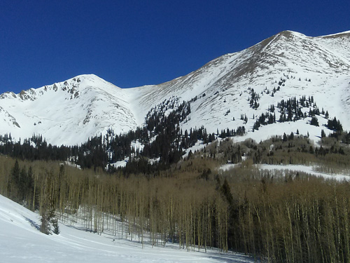
current conditions La Sal Mountains It's been a warm night with no solid refreeze. Temperatures on Pre Laurel Peak barely dipped to freezing at about 4 a.m. and by 5 a.m. it was already 41 degrees at 10,000' in Gold Basin. Ridge top winds have been easterly in the teens with gusts of around 30 mph. It's a mixed bag of conditions out there and the snow surface is tired and worn.
Wind damaged snow in Gold Basin.
Thin cover and sun affected snow on southerly aspects above La Sal Pass. Wind speeds and temperature at 11,700' on Pre-Laurel Peak. New snow totals and temperature at Geyser Pass Trailhead. New snow totals and temperature in Gold Basin. Abajo / Blue Mountains. Low snow conditions prevail but soft snow can be found on sheltered terrain below tree line. In these areas the base depth ranges from 20-30" of snow. Sunnier aspects remain extremely shallow. Winds and temperature on Abajo Peak. Snow total at Buckboard Flat.
|
 |
recent activity
|
| type | aspect/elevation | characteristics |
|---|

|
|
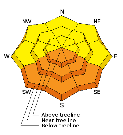
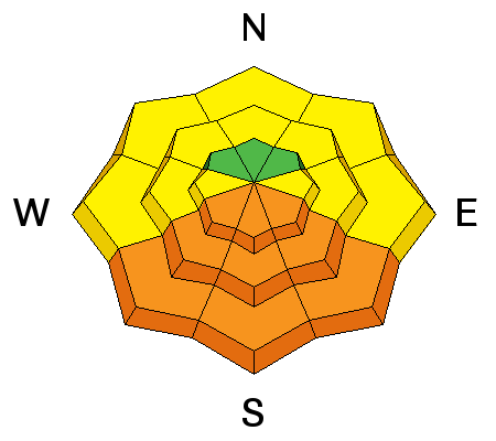
LIKELIHOOD
 LIKELY
UNLIKELY
SIZE
 LARGE
SMALL
TREND
 INCREASING DANGER
SAME
DECREASING DANGER
|
|
description
Without a solid refreeze overnight, sunny skies and extremely warm temperatures forecasted for the mountains today, the danger for wet slide activity will be on the rise. Sun exposed slopes will be the most dangerous but wet sloppy snow will also be an issue on mid to lower elevation shady aspects. Pay attention to signs of instability such as wet point releases, roller balls or pinwheels, and of course wet slide activity. Today will be a day to stay off of and out from under steep slopes as things heat up. |
| type | aspect/elevation | characteristics |
|---|

|

|
LIKELIHOOD
 LIKELY
UNLIKELY
SIZE
 LARGE
SMALL
TREND
 INCREASING DANGER
SAME
DECREASING DANGER
|
|
description
Buried weak layers remain in the snowpack and we still can't let down our guard against the possibility of triggering a dangerous persistent slab. Rapid warming could also increase the likelihood for one of these weaknesses to fail. The danger for triggering a persistent slab exists on upper-mid to upper elevation slopes steeper than 35 degrees that have a NW-N-E aspect, particularly in areas of rocky terrain that have a thin shallow snowpack. |
 |
weather Today will be a scorcher in the mountains with high temperatures at 10,000' of around 50 degrees. Easterly winds will be in the 10-20 mph range. The storm system forecasted to affect our area Tue-Wed is weakening and will likely bring us little more than clouds and continued warm temperatures. |
| general announcements
Grooming Conditions: Trails are scheduled to be groomed on Monday and Friday. Observations: If you are out and about, I would love to know what you are seeing. Please post your observations here. EMAIL ADVISORY If you would like to get the daily advisory by email you will need to subscribe here. Benefit the Utah Avalanche Center when you shop from Backcountry.com or REI: Click this link for Backcountry.com or this link to REI, shop, and they will donate a percent of your purchase price to the UAC. Both offer free shipping (with some conditions) so this costs you nothing! Benefit the Utah Avalanche Center when you buy or sell on ebay - set the Utah Avalanche Center as a favorite non-profit in your ebay account here and click on ebay gives when you buy or sell. You can choose to have your seller fees donated to the UAC, which doesn't cost you a penny. This advisory is from the U.S.D.A. Forest Service, which is solely responsible for its content. This advisory describes general avalanche conditions and local variations always exist. This advisory will be updated on Thursday, January 22. |


_2.jpg)