
| During the month of April, Mark Miller will donate $75 to the charity of your choice (5 to chose from, including the Utah Avalanche Center!) Mark Miller Subaru has raised over $300k in the previous 6 Do Good Feel Good events. More Info here |  |
| During the month of April, Mark Miller will donate $75 to the charity of your choice (5 to chose from, including the Utah Avalanche Center!) Mark Miller Subaru has raised over $300k in the previous 6 Do Good Feel Good events. More Info here | |
| Advisory: Moab Area Mountains | Issued by Eric Trenbeath for Saturday - January 24, 2015 - 6:39am |
|---|


|
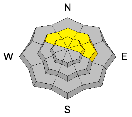
bottom line The danger remains MODERATE for triggering a persistent slab on steep, upper elevation slopes with a NW-N-E aspect, particularly in rocky areas that have a thin, shallow snowpack. Elsewhere in the range the danger is generally LOW but normal mountain travel precautions are advised. Continue to be on the lookout for areas of previously deposited wind drifted snow in exposed upper elevation locations.
|
 |
current conditions La Sal Mountains It's a mixed bag of conditions out there and the snow surface is tired and worn. Best bet for good "recycled" powder conditions is on sheltered slopes below tree line. NE winds overnight have been light, in the single digits with gusting into the teens along ridge tops. Temperatures are inverted this morning. It's 22 degrees on Pre Laurel Peak and 15 at the Gold Basin study plot. Wind speeds and temperature at 11,700' on Pre-Laurel Peak. New snow totals and temperature at Geyser Pass Trailhead. New snow totals and temperature in Gold Basin. Abajo / Blue Mountains. Low snow conditions prevail but soft snow can be found on sheltered terrain below tree line. In these areas the base depth ranges from 20-30" of snow. Sunnier aspects remain extremely shallow. Winds and temperature on Abajo Peak. Snow total at Buckboard Flat.
|
 |
recent activity
|
| type | aspect/elevation | characteristics |
|---|

|
|
LIKELIHOOD
 LIKELY
UNLIKELY
SIZE
 LARGE
SMALL
TREND
 INCREASING DANGER
SAME
DECREASING DANGER
|
|
description
Buried weak layers remain in the snowpack and observers agree that we still can't let our guard down against the possibility of triggering a dangerous persistent slab. The danger for triggering a persistent slab exists primarily on upper-mid to upper elevation slopes steeper than 35 degrees that have a NW-N-E aspect, particularly in areas of rocky terrain that have a thin shallow snowpack. |
| type | aspect/elevation | characteristics |
|---|

|

|
LIKELIHOOD
LIKELY
UNLIKELY
SIZE
 LARGE
SMALL
TREND
INCREASING DANGER
SAME
DECREASING DANGER
|
|
description
Elsewhere in the range the avalanche danger is generally low but normal caution is still advised. Practice safe travel techniques. Ski or ride slopes one at a time. And continue to look for deposits of wind drifted snow on the lee sides of terrain features, particularly in steeper, more extreme terrain. |
 |
weather The doldrums continue through early next week as we remain firmly planted beneath a ridge of high pressure. Sunny skies will prevail through the weekend with high temperatures in the mid 30's on Sat and Sun. Monday, things are really going to heat up with an expected high near 45 degrees at 10,000'. A closed low off of Baja will move across the desert SW Tues into Wed bringing with it the first chance for a change in the weather though confidence in significant precipitation isn't high. The next system looks like it will move into the area on Friday. |
| general announcements
Grooming Conditions: Trails are scheduled to be groomed on Monday and Friday. Observations: If you are out and about, I would love to know what you are seeing. Please post your observations here. EMAIL ADVISORY If you would like to get the daily advisory by email you will need to subscribe here. Benefit the Utah Avalanche Center when you shop from Backcountry.com or REI: Click this link for Backcountry.com or this link to REI, shop, and they will donate a percent of your purchase price to the UAC. Both offer free shipping (with some conditions) so this costs you nothing! Benefit the Utah Avalanche Center when you buy or sell on ebay - set the Utah Avalanche Center as a favorite non-profit in your ebay account here and click on ebay gives when you buy or sell. You can choose to have your seller fees donated to the UAC, which doesn't cost you a penny. This advisory is from the U.S.D.A. Forest Service, which is solely responsible for its content. This advisory describes general avalanche conditions and local variations always exist. This advisory will be updated on Thursday, January 22. |


_2.jpg)
