| During the month of April, Mark Miller will donate $75 to the charity of your choice (5 to chose from, including the Utah Avalanche Center!) Mark Miller Subaru has raised over $300k in the previous 6 Do Good Feel Good events. More Info here |  |
| During the month of April, Mark Miller will donate $75 to the charity of your choice (5 to chose from, including the Utah Avalanche Center!) Mark Miller Subaru has raised over $300k in the previous 6 Do Good Feel Good events. More Info here | |
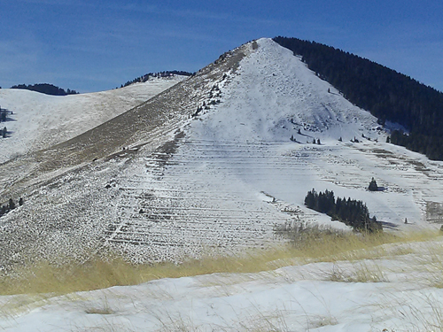
| Advisory: Moab Area Mountains | Issued by Eric Trenbeath for Sunday - January 11, 2015 - 6:57am |
|---|


|
bottom line The avalanche danger is generally LOW at this time but low danger doesn't mean no danger. Loose snow sluffs will be possible on steep upper elevation terrain, and it still may be possible to trigger a persistent slab on steep, upper elevation slopes with a NW-N-E aspect, particularly in rocky areas that have a thin snowpack.
|
 |
special announcement The Utah Avalanche Center Moab will be offering a free "Know Before You Go" avalanche awareness class Thursday, January 15 at 6:30 p.m. at the Grand County Library. |
 |
current conditions La Sal Mountains The mountains received a 2-3" dusting of new snow last night. Though not a dramatic improvement, we'll take what we get. Best bet for decent turns may be on southerly or westerly aspects where the new "dust" sits on top of a supportable crust. Winds have averaged 5 mph from the SW overnight with occasional gusts into the low teens. About 5:00 a.m. they switched to the NW at the same speeds. It is currently 19 degrees on Pre Laurel Peak, and 26 at the Geyser Pass Traihead. Wind speeds and temperature at 11,700' on Pre-Laurel Peak. New snow totals and temperature at Geyser Pass Trailhead. New snow totals and temperature in Gold Basin. On Thursday, Brian Murdock and I poked around near Burro pass we ran across a couple of older slab avalanches that likely occurred during the December 31, southeast wind event. Up to 4' deep, they certainly involved old snow, starting as a wind slab and then stepping down into our persistent weak layers. For details and photos click here. Thanks to everyone who has been posting recent observations. You can post new observations here.
The Abajos currently have an exceedingly thin and shallow snowpack. Click here for a detailed observation.
|
| type | aspect/elevation | characteristics |
|---|

|

|
LIKELIHOOD
 LIKELY
UNLIKELY
SIZE
 LARGE
SMALL
TREND
 INCREASING DANGER
SAME
DECREASING DANGER
|
|
description
The new snow will not have affected the avalanche danger much and conditions are generally stable at this time. Shallow, loose snow sluffs will be possible on very steep terrain, primarily at upper elevations. And it still may be possible to trigger a deep persistent slab on a steep, upper elevation slope with a NW-N-E aspect, particularly in rocky areas that have a thin snowpack. |
 |
weather Today look for mostly cloudy skies with lingering snow showers and another 1-2" of snow possible mainly before noon. Westerly winds will be light with a high near 30 degrees at 10,000'. Monday will be mostly cloudy with a chance of snow. We have a little better shot at more snow Monday night into Tuesday with 3-5" currently being advertised. |
| general announcements
Grooming Conditions: Trails were groomed on Friday but will be covered with a light dusting this morning. Observations: If you are out and about, I would love to know what you are seeing. Please post your observations here. EMAIL ADVISORY If you would like to get the daily advisory by email you will need to subscribe here. Benefit the Utah Avalanche Center when you shop from Backcountry.com or REI: Click this link for Backcountry.com or this link to REI, shop, and they will donate a percent of your purchase price to the UAC. Both offer free shipping (with some conditions) so this costs you nothing! Benefit the Utah Avalanche Center when you buy or sell on ebay - set the Utah Avalanche Center as a favorite non-profit in your ebay account here and click on ebay gives when you buy or sell. You can choose to have your seller fees donated to the UAC, which doesn't cost you a penny. This advisory is from the U.S.D.A. Forest Service, which is solely responsible for its content. This advisory describes general avalanche conditions and local variations always exist. This advisory will be updated on Saturday, January 3 or sooner if conditions warrant. |


_2.jpg)