
| During the month of April, Mark Miller will donate $75 to the charity of your choice (5 to chose from, including the Utah Avalanche Center!) Mark Miller Subaru has raised over $300k in the previous 6 Do Good Feel Good events. More Info here |  |
| During the month of April, Mark Miller will donate $75 to the charity of your choice (5 to chose from, including the Utah Avalanche Center!) Mark Miller Subaru has raised over $300k in the previous 6 Do Good Feel Good events. More Info here | |
| Advisory: Moab Area Mountains | Issued by Eric Trenbeath for Saturday - December 27, 2014 - 6:57am |
|---|

|
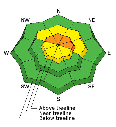
bottom line There danger remains CONSIDERABLE for triggering a persistent slab on upper elevation terrain steeper than 35 degrees on slopes with a NW-N-E aspect. There is a MODERATE danger for triggering a lingering wind slab on exposed, upper elevation terrain steeper than about 35 degrees.
|
 |
current conditions If you missed last weekend's sunny powder day you won't want to miss today. The Christmas storm laid down 10-14" of light density powder on top of the 5" that fell earlier in the week and skiing and riding conditions are about as good as you will find right now. The pack is still shallow in many areas however, and rocks, stumps, and fallen trees remain a hazard. Winds since Christmas night have been negligible, mostly under 10 mph along ridge tops. Last night they made a brief jump into the low teens with gusts into the 20's out of the NW, but since 3 a.m. they have been dead calm.Temperatures are cold this morning, -5 on Pre Laurel Peak, and 0 a the Geyser Pass Trailhead. Total depth in Gold Basin is 42" and at Geyser Pass Trailhead the base is 29". Mountain weather conditions at 11,700' on Pre-Laurel Peak. Snow totals at Geyser Pass Trailhead. New snow totals in Gold Basin. |
| type | aspect/elevation | characteristics |
|---|

|
|
LIKELIHOOD
 LIKELY
UNLIKELY
SIZE
 LARGE
SMALL
TREND
 INCREASING DANGER
SAME
DECREASING DANGER
|
|
description
We have been adding straw to the camel's back so to speak, with each storm and wind event adding more stress to faceted weak layers buried in the snow pack. Though isolated, there is now considerable likelihood of triggering a persistent slab on one of these buried weak layers primarily at upper elevations on slopes steeper than 35 degrees that have a NW-N-E aspect. |
| type | aspect/elevation | characteristics |
|---|

|

|
LIKELIHOOD
 LIKELY
UNLIKELY
SIZE
 LARGE
SMALL
TREND
INCREASING DANGER
SAME
DECREASING DANGER
|
|
description
A few lingering wind slabs formed earlier in the week may still be found in the wind zone at upper elevations. Keep an eye out for smooth, rounded pillows of recently deposited wind drifted snow. |
 |
weather Today should see mostly sunny skies, light winds, and cold temperatures with a high of around 15 degrees at 10,000'. Clouds will begin to move in tonight ahead of the next series of storms. Sunday will be mostly cloudy with the best chance for a little snow coming Sunday night into Monday. Sunday: A 20 percent chance of snow after 10am. Mostly cloudy, with a high near 19. West wind 10 to 15 mph. |
| general announcements
Grooming Conditions: 8"-10" of new snow will be on top of the track today. Ed and Gerrish got the roller out on Wednesday and took it into Gold Basin and up to Geyser Pass. They also moved the trees off the road that blew down during Monday's wind event. Observations: If you are out and about, I would love to know what you are seeing. Please post your observations here. EMAIL ADVISORY If you would like to get the daily advisory by email you will need to subscribe here. Benefit the Utah Avalanche Center when you shop from Backcountry.com or REI: Click this link for Backcountry.com or this link to REI, shop, and they will donate a percent of your purchase price to the UAC. Both offer free shipping (with some conditions) so this costs you nothing! Benefit the Utah Avalanche Center when you buy or sell on ebay - set the Utah Avalanche Center as a favorite non-profit in your ebay account here and click on ebay gives when you buy or sell. You can choose to have your seller fees donated to the UAC, which doesn't cost you a penny. This advisory is from the U.S.D.A. Forest Service, which is solely responsible for its content. This advisory describes general avalanche conditions and local variations always exist. |


_2.jpg)