
| During the month of April, Mark Miller will donate $75 to the charity of your choice (5 to chose from, including the Utah Avalanche Center!) Mark Miller Subaru has raised over $300k in the previous 6 Do Good Feel Good events. More Info here |  |
| During the month of April, Mark Miller will donate $75 to the charity of your choice (5 to chose from, including the Utah Avalanche Center!) Mark Miller Subaru has raised over $300k in the previous 6 Do Good Feel Good events. More Info here | |
| Advisory: Moab Area Mountains | Issued by Eric Trenbeath for Friday - December 26, 2014 - 6:52am |
|---|


|
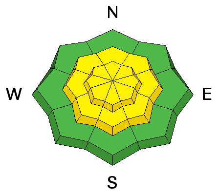
bottom line There danger is CONSIDERABLE today for triggering recently deposited wind slabs, primarily on upper elevation, wind exposed terrain steeper than 30 degrees that have a W-N-E aspect. Be alert to smooth rounded deposits of wind drifted snow, and watch for signs of instability such as cracking in the snow surface or collapsing of the snowpack. There is also a CONSIDERABLE today for triggering a deeper persistent slab on upper elevation terrain steeper than 35 degrees on slopes with a NW-N-E aspect.
|
 |
current conditions The La Sal mountains received a nice present in the form of 8"-12" of light density snow with greater amounts likely at upper elevations. This new snow fell on top of Tuesday's denser and windblown 5" and skiing and riding conditions should be excellent today. Southerly winds yesterday averaged 15 -25 mph with a few gusts as high as 40 but as of 7 p.m. they switched to more easterly and have backed off into the single digits. It is a frigid 0 degrees on Pre Laurel Peak, and 7 at the Geyser Pass Trailhead. Mountain weather conditions at 11,700' on Pre-Laurel Peak. Snow totals at Geyser Pass Trailhead. New snow totals in Gold Basin. |
| type | aspect/elevation | characteristics |
|---|

|
|
LIKELIHOOD
 LIKELY
UNLIKELY
SIZE
 LARGE
SMALL
TREND
 INCREASING DANGER
SAME
DECREASING DANGER
|
|
description
With up to a foot of new, light density snow, there will be the potential for loose snow sluffs in steeper terrain. I suspect most of the natural activity occurred overnight, but today you will still be able to trigger these mostly manageable slides. Try cutting the slope first to get the new snow to sluff off. Be mindful of how much snow gets picked up by these slides as they move down the slope, as well as the type of terrain they are sliding into.
|
| type | aspect/elevation | characteristics |
|---|

|
|
LIKELIHOOD
 LIKELY
UNLIKELY
SIZE
 LARGE
SMALL
TREND
INCREASING DANGER
SAME
DECREASING DANGER
|
|
description
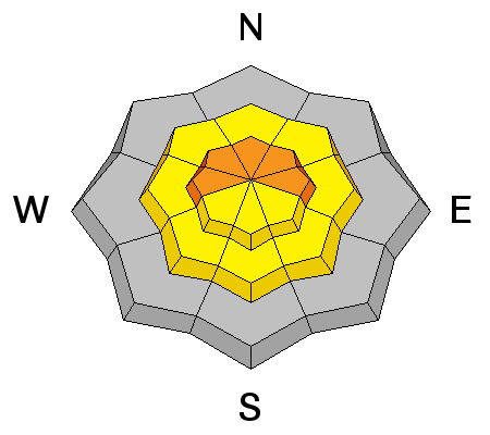
Though winds weren't totally out of hand yesterday, they blew enough to move snow around and there was plenty available for transport. Expect to find recently deposited wind slabs in wind exposed areas at and above tree line that have a W-N-E aspect. Avoid slopes steeper than about 30 degrees and look for signs of instability such as smooth pillows of recently drifted snow, cracking in the snow surface, or collapsing of the snow pack. |
| type | aspect/elevation | characteristics |
|---|

|
|
LIKELIHOOD
LIKELY
UNLIKELY
SIZE
LARGE
SMALL
TREND
INCREASING DANGER
SAME
DECREASING DANGER
|
|
description
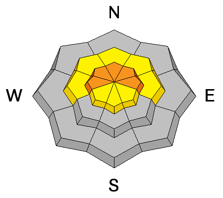
New wind drifts will provide extra stress on buried persistent slabs. The November snow is turning to facets, or weak sugary snow, and we are now starting to get a load on top. In some cases, old stiff slabs overly these facets, and they are now covered by anywhere from 1-2' of new snow. There is also a very weak layer of mid pack faceting associated with a crust. The concern now is triggering a slide that will step down into one off these buried weaknesses. You are most likely to encounter this problem on slopes steeper then 35 degrees on upper elevation slopes with a NW-N-E aspect. |
 |
weather The storm system is slowly moving out of our region and today will remain cloudy, cold with lingering snow. 2"-4" is possible today with high temperatures at 10,000' to be around 12 degrees. Winds will be light and northerly at 10-15 mph. Saturday looks to be mostly sunny as brief ridge builds ahead of the next system which will bring us a chance of snow Sunday evening into Monday. |
| general announcements
Grooming Conditions: 8"-10" of new snow will be on top of the track today. Ed and Gerrish got the roller out on Wednesday and took it into Gold Basin and up to Geyser Pass. They also moved the trees off the road that blew down during Monday's wind event. Observations: If you are out and about, I would love to know what you are seeing. Please post your observations here. EMAIL ADVISORY If you would like to get the daily advisory by email you will need to subscribe here. Benefit the Utah Avalanche Center when you shop from Backcountry.com or REI: Click this link for Backcountry.com or this link to REI, shop, and they will donate a percent of your purchase price to the UAC. Both offer free shipping (with some conditions) so this costs you nothing! Benefit the Utah Avalanche Center when you buy or sell on ebay - set the Utah Avalanche Center as a favorite non-profit in your ebay account here and click on ebay gives when you buy or sell. You can choose to have your seller fees donated to the UAC, which doesn't cost you a penny. This advisory is from the U.S.D.A. Forest Service, which is solely responsible for its content. This advisory describes general avalanche conditions and local variations always exist. |


_2.jpg)