
| During the month of April, Mark Miller will donate $75 to the charity of your choice (5 to chose from, including the Utah Avalanche Center!) Mark Miller Subaru has raised over $300k in the previous 6 Do Good Feel Good events. More Info here |  |
| During the month of April, Mark Miller will donate $75 to the charity of your choice (5 to chose from, including the Utah Avalanche Center!) Mark Miller Subaru has raised over $300k in the previous 6 Do Good Feel Good events. More Info here | |
| Advisory: Moab Area Mountains | Issued by Eric Trenbeath for Friday - April 4, 2014 - 6:26am |
|---|


|
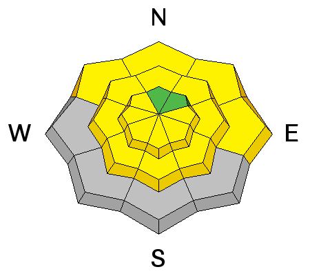
bottom line Today, there will be a MODERATE danger for wet slide activity. The danger will rise as the day heats up, and both human and natural avalanches are possible on sun exposed slopes. There is also a MODERATE danger for triggering loose snow sluffs, or shallow wind deposits on steep, upper elevation slopes, primarily with northerly aspects.
|
 |
current conditions La Sal Mountains Wednesday's storm produced 4"-6" of relatively light density snow. This brings our total on the ground in Gold Basin to its greatest depth of the season at 56". Good powder conditions were found yesterday though the bottom could be felt in most areas. The sun did make an appearance yesterday and many exposed surfaces felt the effects. Today, you will have to seek out the upper elevation, northerly aspects to find dry snow. Winds have been mostly light the past 24 hours, averaging 10-15 mph. They were primarily out of the north yesterday but have switched to more southerly this morning. It is currently 13 degrees on Pre Laurel Peak. Winds and temperature on Pre-Laurel Peak (11,705') Temperature and new snow totals in Gold Basin (10,050') Total snow depth and temperature near Geyser Pass Trailhead (9850') Abajo Mountains We are through issuing information on conditions in the Abajo Mountains. You can get current weather and snow pack data on the links below. Winds and temperature on Abajo Peak. Snow totals at Camp Jackson (8968') |
| type | aspect/elevation | characteristics |
|---|

|
|
LIKELIHOOD
 LIKELY
UNLIKELY
SIZE
 LARGE
SMALL
TREND
 INCREASING DANGER
SAME
DECREASING DANGER
|
|
description
With partly sunny skies, and temperatures forecasted to be in the mid to high 30's today, you will need to be alert to the dangers of wet slide activity. The sun is strong and high in the sky this time of year, and even slopes with more northerly aspects are suspect, particularly at lower to mid elevations. Any dry snow that is hit by the sun will quickly be affected, and what starts as a loose, dry, powder sluff, could quickly develop into a dense, wet slide. Timing will be everything today. If you notice the snow getting sloppy, or observe signs such as roller balls or sluffing, it is time to get off of, and out from under steep slopes. |
| type | aspect/elevation | characteristics |
|---|

|

|
LIKELIHOOD
LIKELY
UNLIKELY
SIZE
LARGE
SMALL
TREND
 INCREASING DANGER
SAME
DECREASING DANGER
|
|
description
On upper elevation, northerly aspects, it still may be possible to trigger shallow, loose sluffs, or recent wind drifts on steep terrain. These should be small, and manageable, but could sweep you off your feet and carry you over a rock band in extreme terrain. |
 |
weather Today will see the ridge of high pressure moving east, ahead of the next Pacific storm system that will start moving into our area later tonight. Today, expect partly sunny skies with high temperatures at 10,000' to be in the mid to upper 30's. SW winds will be in the 10-15 mph range. Snow showers should develop by Saturday, with 2"-4" possible. |
| general announcements OBSERVATIONS: If you are out and about in the mountains, I'd love to know what you are seeing so please SUBMIT OBSERVATIONS You can read current OBSERVATIONS HERE. ROAD CONDITIONS: Expect the road to be muddy today. UAC MOBILE APP: Get your advisory on your iphone with this app
|


_2.jpg)