| During the month of April, Mark Miller will donate $75 to the charity of your choice (5 to chose from, including the Utah Avalanche Center!) Mark Miller Subaru has raised over $300k in the previous 6 Do Good Feel Good events. More Info here |  |
| During the month of April, Mark Miller will donate $75 to the charity of your choice (5 to chose from, including the Utah Avalanche Center!) Mark Miller Subaru has raised over $300k in the previous 6 Do Good Feel Good events. More Info here | |
| Advisory: Moab Area Mountains | Issued by Eric Trenbeath for Tuesday - March 25, 2014 - 7:17am |
|---|

|
bottom line The Avalanche danger is generally LOW at this time, but the danger for wet slide activity will rise to MODERATE on sun exposed slopes as the day heats up. It is also important to maintain general awareness to the problems of 1) recently deposited wind slabs in exposed, upper elevation terrain, 2) buried persistent slabs in areas that have the weakest snow pack.
|
 |
special announcement This advisory will be updated twice weekly for the remainder of our operating season unless significant changes occur. This advisory was updated at 7:30 a.m. on Tuesday, March 25. The next advisory will be posted on Friday, March 28, or sooner if conditions warrant. |
 |
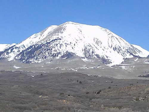
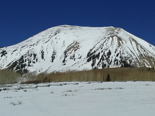
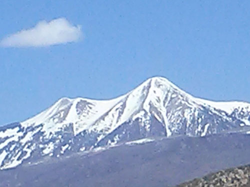
current conditions La Sal Mountains Today will be the last day for a corn harvest for awhile. Several warm and sunny days with clear freezing nights will make for optimum conditions on E--S-W facing slopes that still have snow on them. Many of these slopes are melting out already however, so you will have to pick and choose. I made a trip over to the east side off Mt. Peale on Sunday and this classic run was already showing rocks and bushes, while the south shoulder was already bare. Tuklear Reaction was as thin as I've ever seen it this time of year. Norrth facing bowls are holding plenty of snow, but for now, they are mostly wind damaged.
Winds and temperature on Pre-Laurel Peak (11,705') Temperature and new snow totals in Gold Basin (10,050') Total snow depth and temperature near Geyser Pass Trailhead (9850') Abajo Mountains The Abajos have an extremely low snow pack and most south facing slopes are already melted off. Winds and temperature on Abajo Peak. Snow totals at Camp Jackson (8968') |
| type | aspect/elevation | characteristics |
|---|

|
|
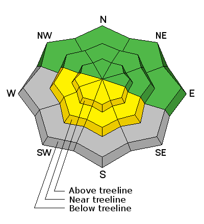
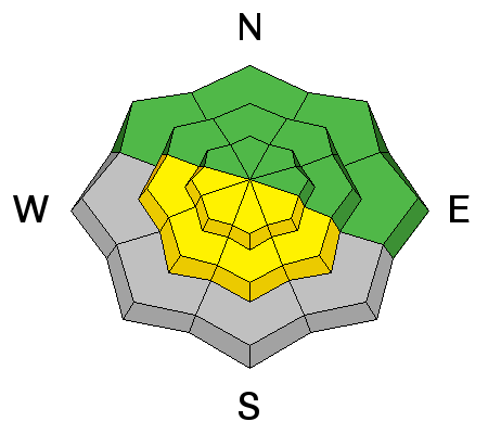
LIKELIHOOD
 LIKELY
UNLIKELY
SIZE
 LARGE
SMALL
TREND
 INCREASING DANGER
SAME
DECREASING DANGER
|
|
description
The Avalanche Danger is generally low at this time, but remember that low danger doesn't mean no danger. Normal caution and avalanche awareness need to be maintained against the following potential dangers: 1) Wet Slide: As temperatures rise during the day, be alert to the signs and dangers of wet slide activity such as roller balls, pinwheels, or loose sluffs coming down the mountain. If you find yourself punching through into sloppy wet snow, it is time to get off of, and out form under steep slopes. This danger will rise to moderate as the day heats up. 2) Persistent Slab: It has been 3 weeks since the last large, persistent slab avalanche occurred. Nevertheless, areas of weak snow with an overlying slab may still exist. Areas of weakest snow can be found in steep, rocky, or slightly wooded terrain, facing the north half of the compass, at upper mid to upper elevations. Or right around tree line. I would still exercise caution in these areas. 3) Wind Slab: Always maintain awareness of recent deposits of wind drifted snow on the lee sides of ridge crests or terrain features. Look for characteristic smooth, rounded pillows, or areas that have a hollow feel to them.
|
 |
weather Today will be our last sunny day ahead of an approaching storm system that will mainly affect areas north. By Wednesday we will see increasing clouds, SW winds, and a chance for snow through Thursday. |
| general announcements OBSERVATIONS: If you are out and about in the mountains, I'd love to know what you are seeing so please SUBMIT OBSERVATIONS You can read current OBSERVATIONS HERE. ROAD CONDITIONS: The road is passable but a bit rugged. The lower part is dry, and then it alternates between patches of dry ground, snow ruts, and packed snow and ice that gets sloppy late in the day. UAC MOBILE APP: Get your advisory on your iphone with this app
|


_2.jpg)