
| During the month of April, Mark Miller will donate $75 to the charity of your choice (5 to chose from, including the Utah Avalanche Center!) Mark Miller Subaru has raised over $300k in the previous 6 Do Good Feel Good events. More Info here |  |
| During the month of April, Mark Miller will donate $75 to the charity of your choice (5 to chose from, including the Utah Avalanche Center!) Mark Miller Subaru has raised over $300k in the previous 6 Do Good Feel Good events. More Info here | |
| Advisory: Moab Area Mountains | Issued by Eric Trenbeath for Friday - February 28, 2014 - 6:33am |
|---|


|
bottom line There is a CONSIDERABLE avalanche danger at upper elevations in areas that have recent deposits of wind drifted snow. This danger is expected to rise if forecasted amounts of snow materialize. There is a MODERATE avalanche danger at mid and lower elevations.
|
 |
special avalanche bulletin
|
 |
current conditions La Sal Mountains The mountains picked up 4"-6" of moderately dense, new snow over the past 24 hours. SW winds blew strong yesterday, averaging 20-30 mph along ridge tops with one gust recorded at 70 mph! They have backed off this morning and are in the single digits from the WSW. Temperatures have been on a steady decline since yesterday and it is currently 20 degrees at the Geyser Pass Trailhead, and 12 degrees on Pre Laurel Peak. Winds and temperature on Pre-Laurel Peak (11,705') Temperature and new snow totals in Gold Basin (10,050') Total snow depth and temperature near Geyser Pass Trailhead (9850') Abajo Mountains Buckboard Flat is reporting a couple inches of new snow. Low snow conditions still prevail in the Abajos, with total water content for the year coming in at 56% of normal. Winds on Abajo Peak are averaging 20 -30 mph from the WSW. It is currently 27 degrees at Buckboard Flat. ' . Winds and temperature on Abajo Peak (11,330') Snow totals at Camp Jackson (8968') |
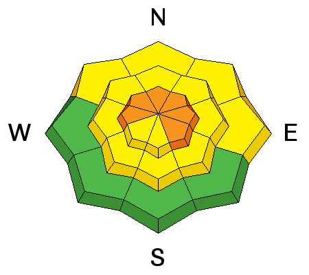
| type | aspect/elevation | characteristics |
|---|

|
|
LIKELIHOOD
 LIKELY
UNLIKELY
SIZE
 LARGE
SMALL
TREND
 INCREASING DANGER
SAME
DECREASING DANGER
|
|
description
Expect to find shallow wind slabs at upper elevations on slopes with a NW-E-SE aspect. These slabs will grow in size and become more dangerous as winds increase through the day, and especially into the weekend as new snow piles up.
|
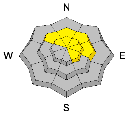
| type | aspect/elevation | characteristics |
|---|

|
|
LIKELIHOOD
 LIKELY
UNLIKELY
SIZE
 LARGE
SMALL
TREND
INCREASING DANGER
SAME
DECREASING DANGER
|
|
description
In my travels yesterday, I was still observing collapsing of the snow pack, a strong reminder that there is plenty of weak snow under there. The danger for triggering a deeper, persistent slab will rise over the weekend as new snow piles up.
|
 |
weather We will get a little lull today between storms with what looks like a little sunshine this morning. Clouds will build today ahead of a powerful Pacific Storm slated to hit us tonight through Saturday.SW winds will be on the increase today, averaging 2-30 mph along ridge tops by this afternoon. 4"-8" of new snow are possible tonight, with an other 3"-7" on Saturday. Showers should linger into Sunday. |
| general announcements OBSERVATIONS: If you are out and about in the mountains, I'd love to know what you are seeing so please SUBMIT OBSERVATIONS You can read current OBSERVATIONS HERE. LUNA GROOMING INFORMATION: Grooming is on hold due to the impending storm. ROAD CONDITIONS: The road is not plowed but is passable. UAC MOBILE APP: Get your advisory on your iphone with this app
|


_2.jpg)
