| During the month of April, Mark Miller will donate $75 to the charity of your choice (5 to chose from, including the Utah Avalanche Center!) Mark Miller Subaru has raised over $300k in the previous 6 Do Good Feel Good events. More Info here |  |
| During the month of April, Mark Miller will donate $75 to the charity of your choice (5 to chose from, including the Utah Avalanche Center!) Mark Miller Subaru has raised over $300k in the previous 6 Do Good Feel Good events. More Info here | |
| Advisory: Moab Area Mountains | Issued by Eric Trenbeath for Friday - February 21, 2014 - 6:44am |
|---|

|
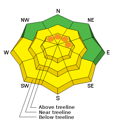
bottom line The avalanche danger is generally MODERATE or Level 2. Back country travelers need to maintain a heightened level of awareness, being alert to the possibility of triggering a newly formed wind slab or buried persistent slab. Pockets of CONSIDERABLE danger still exist where you can trigger a buried persistent slab, primarily on steep, upper elevation slopes that face the north half of the compass. With daytime heating, there will also be a MODERATE danger for wet slide activity on sun exposed slopes.
|
 |
special avalanche bulletin
|
 |
current conditions La Sal Mountains The mountains picked up 2"-4" of spongey snow and graupel from Thursday night's event. This was enough to improve conditions a bit and yesterday I found good "dust on crust" on south faces, and smooth, fast, dry conditions in sheltered areas. The real story this week has been the wind however, and as they say, Mother Nature giveth, Mother Nature taketh away. Much of the snow we received early this month has been stripped away by northerly winds. Exposed ridge tops that once had new slabs up to 2' deep, have now been stripped to near bare ground. Upper bowls and cirques alternate between wind scour and crusts, to settled, dense, creamy snow. There are good skiing and riding conditions out there, you just have to pick and choose. Winds have finally tapered off, steadily decreasing overnight and are currently blowing 10-15 mph from the NW. The temperature at 10,000' is 12 degrees.
Winds and temperature on Pre-Laurel Peak (11,705') Temperature and new snow totals in Gold Basin (10,050') Total snow depth and temperature near Geyser Pass Trailhead (9850') Abajo Mountains Mother Nature has not been kind to the Abajos. 2" of new snow fell at Buckboard Flat Thursday night, but low snow conditions still remain. Winds through the week have only added insult to injury. The snow pack depth averages between 18" and 36", but some sun and wind exposed slopes are showing bare ground. Westerly winds are a little stronger on Abajo Peak, averaging 15-20 mph and still gusting to 30. It is 27 degrees at 9000' .
Winds and temperature on Abajo Peak (11,330') Snow totals at Camp Jackson (8968') |
| type | aspect/elevation | characteristics |
|---|

|
|
LIKELIHOOD
 LIKELY
UNLIKELY
SIZE
 LARGE
SMALL
TREND
 INCREASING DANGER
SAME
DECREASING DANGER
|
|
description
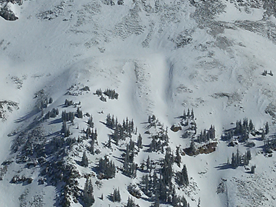
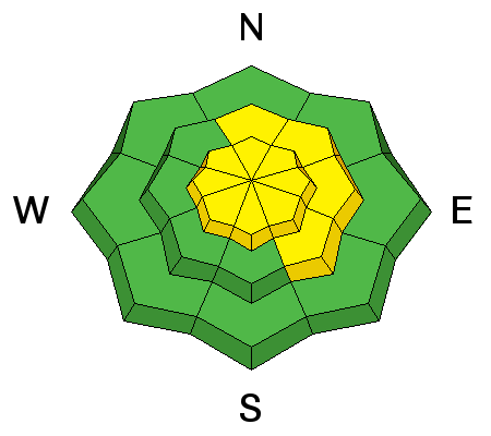
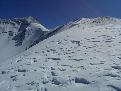
Changing wind directions of the past week have scattered isolated wind slabs around. These can be found on the lee sides of terrain features and in areas where cross loading has been a factor. Most are stiff, stubborn to release, and may even be difficult to recognize. They may appear as wind damaged snow, existing on the lee side of subtle terrain features, surrounded by wind scoured terrain. Be alert to hollow sounding snow, and mind the consequences. Photo illustrates stiff wind slab deposition in gullies from cross loading.
|
| type | aspect/elevation | characteristics |
|---|

|
|
LIKELIHOOD
LIKELY
UNLIKELY
SIZE
 LARGE
SMALL
TREND
INCREASING DANGER
SAME
DECREASING DANGER
|
|
description
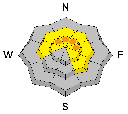
Persistent slab danger still exists though generally speaking we are moving into a low probability high consequence scenario. There hasn't been any new avalanche activity for nearly two weeks, and the now pack seems to have largely adjusted to the weight of snow received early this month. Nevertheless, there is still plenty of weak snow under there. The one collapse I observed yesterday was enough to remind me that it is still possible to wind up in the wrong place at the wrong time. Take into account the consequences of triggering a deep avalanche and choose yout terrain wisely.
|
| type | aspect/elevation | characteristics |
|---|

|

|
LIKELIHOOD
LIKELY
UNLIKELY
SIZE
LARGE
SMALL
TREND
 INCREASING DANGER
SAME
DECREASING DANGER
|
|
description
With sunny skies and warmer temperatures over the next several days, we will likely see loose, wet slide activity on sun exposed slopes in the afternoon.
|
 |
weather Today looks to be mostly sunny with high temperatures climbing up into the mid 30's. Saturday and Sunday look to be the same with temperatures getting slightly warmer. |
| general announcements OBSERVATIONS: If you are out and about in the mountains, I'd love to know what you are seeing so please SUBMIT OBSERVATIONS You can read current OBSERVATIONS HERE. LUNA GROOMING INFORMATION: Grooming equipment is up and running again and though I can't say for sure, I expect they will be out grooming today. ROAD CONDITIONS: A light dusting from Thursday has been packed in and the road is passable. UAC MOBILE APP: Get your advisory on your iphone with this app
|


_2.jpg)

 .
.