| During the month of April, Mark Miller will donate $75 to the charity of your choice (5 to chose from, including the Utah Avalanche Center!) Mark Miller Subaru has raised over $300k in the previous 6 Do Good Feel Good events. More Info here |  |
| During the month of April, Mark Miller will donate $75 to the charity of your choice (5 to chose from, including the Utah Avalanche Center!) Mark Miller Subaru has raised over $300k in the previous 6 Do Good Feel Good events. More Info here | |
| Advisory: Moab Area Mountains | Issued by Eric Trenbeath for Monday - February 17, 2014 - 6:40am |
|---|

|
bottom line There remains a CONSIDERABLE avalanche danger in areas that have recent deposits of wind drifted snow, and in areas where it is possible to trigger a buried, persistent slab. These dangers are primarily found on mid to upper elevation slopes, steeper than 34 degrees, that have a NW-E-SE aspect. As temperatures rise, there will be a MODERATE danger for wet slide activity.
|
 |
special avalanche bulletin This advisory is based on field work performed over the period of February 13-16, and weather data received on Monday, February 17. It is to be used as a guideline for back country travelers so that they can form their own danger analysis over the next several days. Unseasonably warm temperatures over the weekend caused many changes to the snow pack and conditions have turned much more spring like. Rapid warming, and warm, overnight low temperatures created a heightened period of instability over the weekend. In addition, sustained westerly winds continued to transport snow on to leeward slopes, creating dangerous wind slabs, and adding further weight and stress to buried, persistent slabs. Time and solid re-freezes will help to stabilize these conditions, but back country travelers need to maintain a heightened level of awareness. |
 |
current conditions La Sal Mountains We had a good solid freeze Sunday night. Temperatures at 6:00 am were 16 degrees on Pre-Laurel Peak, 15 in Gold Basin, and 23 at the Geyser Pass Trailhead. NW winds blew strong most of the night but backed off into the 10-15 mph range by early morning. Mid and upper elevations still hold dry snow on shady slopes, but the wind has affected exposed, westerly aspects. All sunny aspects are crusted over, and the lower elevation snow pack has gone isothermal. Winds and temperature on Pre-Laurel Peak (11,705') Temperature and new snow totals in Gold Basin (10,050') Total snow depth and temperature near Geyser Pass Trailhead (9850') Abajo Mountains Low snow conditions still remain in the Abajo Mountains. The snow pack depth averages between 18" and 36", but some sun and wind exposed slopes are showing bare ground. For more information, see this report Westerly winds on Abajo Peak blew strong Sunday night and continued to average 25 mph early Monday morning. The overnight low on Abajo Peak was 19 degrees, and 31 at Camp Jackson.
Winds and temperature on Abajo Peak (11,330') Snow totals at Camp Jackson (8968') |
 |
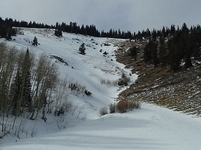
recent activity With the exception of wet, loose snow avalanches, no new major activity has been observed in over a week. I've been able to get out and look around at things and , and we did have a natural avalanche cycle the weekend of February 9-10. Many natural storm snow avalanches occurred, but a few slides managed to step down into older, buried facets. Most notable was a large slide on the Horse's Head in the Abajo Mountains, and a large slide in Upper Horse Creek in the La Sals. Click here to see some of the avalanche reports. |
| type | aspect/elevation | characteristics |
|---|

|

|
LIKELIHOOD
 LIKELY
UNLIKELY
SIZE
 LARGE
SMALL
TREND
 INCREASING DANGER
SAME
DECREASING DANGER
|
|
description
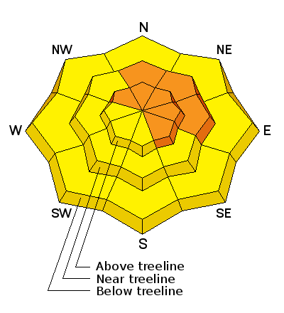
Steady, westerly winds have deposited wind slabs 2-3' deep on upper elevation, leeward slopes. These slabs have gained strength and will be more difficult to trigger, however, triggering one would be extremely dangerous. They also wield the potential to step down into a buried persistent slab causing a large, and possibly un-survivable avalanche. This danger is most prevalent on upper elevation slopes. steeper than 34 degrees that have a N-E-SE aspect.
|
| type | aspect/elevation | characteristics |
|---|

|
|
LIKELIHOOD
 LIKELY
UNLIKELY
SIZE
 LARGE
SMALL
TREND
 INCREASING DANGER
SAME
DECREASING DANGER
|
|
description
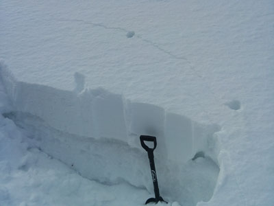
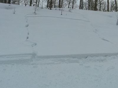
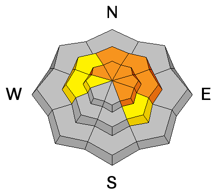
We are in a tenuous balance out there. The underlying snow pack is very weak. Over the weekend I observed several large collapses indicating that the pack has yet to adjust to the most recent load. The possibility of triggering a deep, persistent slab is a very real and present danger, and steep, N-E-SE facing terrain at upper mid-upper elevations should still be avoided. Photo illustrates cracking in the snow of the past 10 days that has consolidated over top of very weak snow.
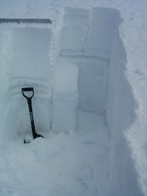
Snow pit illustrates weak layers in the snow pack with a very clean shear on mid level facets. CT12 Q3
|
| type | aspect/elevation | characteristics |
|---|

|

|
LIKELIHOOD
LIKELY
UNLIKELY
SIZE
LARGE
SMALL
TREND
 INCREASING DANGER
SAME
DECREASING DANGER
|
|
description
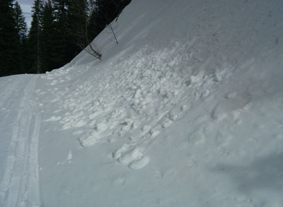
With a good freeze over Saturday and Sunday nights, the snow has locked up a bit. The Forecasted temperatures for the week are expected to be cooler, but be alert to the danger for wet slide activity as daytime heating progresses. Stay off of and out from under steep slopes as the day heats up, and be alert to signs of instability such as roller balls, wet sluffs, and soft, sloppy snow up over your boot tops. Photo illustrates wet roller balls as a sing of instability:
Photo illustrates a snowmobile triggered slope collapse of wet snow over weak, faceted, sugar snow.
|
 |
weather Today will be mostly sunny with high temperatures at 10,000' around 36 degrees. Winds will be westerly in the 10-15 mph range. Tuesday looks to be mostly sunny with clouds moving in mid week ahead of a weak disturbance that doesn't hold much promise at this time. Tuesday: Mostly sunny, with a high near 37. West wind 10 to 15 mph. |
| general announcements OBSERVATIONS: If you are out and about in the mountains, I'd love to know what you are seeing so please SUBMIT OBSERVATIONS You can read current OBSERVATIONS HERE. LUNA GROOMING INFORMATION: Trails are groomed and are in excellent shape. Get on them on the morning for fastest conditions. ROAD CONDITIONS: The road is snow packed but clear. UAC MOBILE APP: Get your advisory on your iphone with this app
|


_2.jpg)