| During the month of April, Mark Miller will donate $75 to the charity of your choice (5 to chose from, including the Utah Avalanche Center!) Mark Miller Subaru has raised over $300k in the previous 6 Do Good Feel Good events. More Info here |  |

For every car Mark MIller Subaru sells in April, they will donate $75 to the charity of your choice (5 to choose from). Who are you going to choose? Plus - you can vote for your favorite and the 3 groups receiving the most votes get an additional cash prize donated by Mark Miller Subaru. Details here

| During the month of April, Mark Miller will donate $75 to the charity of your choice (5 to chose from, including the Utah Avalanche Center!) Mark Miller Subaru has raised over $300k in the previous 6 Do Good Feel Good events. More Info here |  |
| Advisory: Moab Area Mountains | Issued by Eric Trenbeath for Saturday - February 8, 2014 - 6:47am |
|---|
 |
current conditions La Sal Mountains Deep powder conditions still prevail and excellent turning and riding conditions abound. The mountains received 18"-24" of snow this week, and though it has begun to settle out, trail breaking remains arduous. Winds have been on the increase last night, averaging in the low 20's with gusting to near 40 mph along ridge tops from the SW. This will affect the snow surface, stiffening things up in exposed areas, and of course, increasing the avalanche danger by deposited wind slabs on leeward slopes. There is 32" on the ground at Geyser Pass Trailhead, and 52" in Gold Basin. It is currently 20 degrees at 10,000'. Winds and temperature on Pre-Laurel Peak (11,705') Temperature and new snow totals in Gold Basin (10,050') Total snow depth and temperature near Geyser Pass Trailhead (9850') Abajo Mountains No new snow has fallen in the the Abajos since Tuesday, where storm totals were about 6" of light density snow. Conditions are improving, but we definitely need some more! Winds on Abajo Peak have been on the increase, averaging 20 mph from the SW with gusting to 25 mph. It is currently 17 degrees up there. Winds and temperature on Abajo Peak (11,330') Snow totals at Camp Jackson (8968') |
 |
recent activity In my travels yesterday, I noticed numerous crowns sprinkled throughout Gold Basin that occurred during the storm cycle earlier this week. Pockety best describes these slides as most of them were under 50' wide. All were on steep, N and NE facing terrain, at upper mid elevations. Most occurred in and around rock bands and also in very steep, wooded areas. The large, upper bowls have stayed in place. Crowns averaged about two feet in depth, and were failing on faceted snow beneath the storm of a week ago. |
| type | aspect/elevation | characteristics |
|---|


|


|

LIKELIHOOD
 LIKELY
UNLIKELY
SIZE
 LARGE
SMALL
TREND
 INCREASING DANGER
SAME
DECREASING DANGER
|
|
description
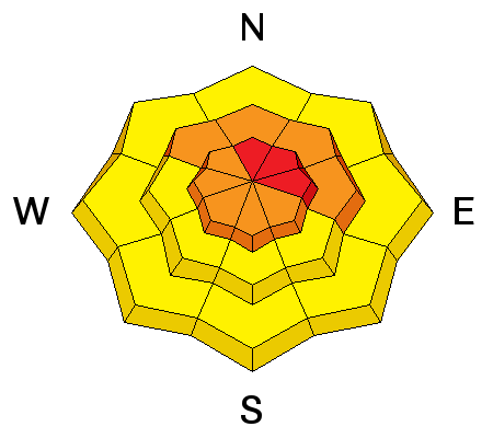
Yesterday, I observed a steady stream of snow being transported on to the lee sides of upper elevation ridges. Relatively light, but steady winds have been doing this all week long up there, and wind drifts up to 3' deep now exist on upper elevation N-NE aspects. Gazing into Horse Creek gave me an ominous sense of impending doom, and this sense will increase today as the winds begin to howl. Expect to find deep and dangerous wind slabs on steep, N-NE-E aspects today. Stay off of, and out from under these slopes today. With strong winds and so much snow available for transport, slabs will also be forming any where they can, so be alert to cross loading on all aspects on the lee sides of terrain features, particularly at upper elevations.
|
| type | aspect/elevation | characteristics |
|---|


|


|

LIKELIHOOD
 LIKELY
UNLIKELY
SIZE
 LARGE
SMALL
TREND
 INCREASING DANGER
SAME
DECREASING DANGER
|
|
description
Snow stability tests yesterday indicated that the new snow weight is dangerously close to affecting buried, persistent weak layers in the snow pack. Currently, all that is needed to trigger a large avalanche into deeper, old snow is a significant trigger. This could easily be you. In addition, strong winds today will transport significant amounts of snow, adding further weight and stress to these buried weak layers. It is a very delicate balance out there right now, and the possibility of triggering a deep, persistent slab is a very real and present danger. |
 |
weather We are on the fringe edge of a powerful winter storm system that seems to be bringing us mostly wind. West winds today will be in the 20-25 mph range with gusting into the 40's along ridge tops. High temperatures today will be in the upper 20's. 1"-3" of new snow is possible today, with another 2"-4" possible tonight. Breezy conditions with a chance of snow continues through the weekend and into Monday. |
| general announcements OBSERVATIONS: If you are out and about in the mountains, I'd love to know what you are seeing so please SUBMIT OBSERVATIONS You can read current OBSERVATIONS HERE. LUNA GROOMING INFORMATION: Most of the snow has been packed in now but we are still looking for a volunteer to put the finishing touches on grooming today. Moab Cliffs and Canyons is sponsoring a free, ski demo and clinic on Sunday, February 9, from 10 a.m. to 3 p.m. at the Geyser Pass Winter Trailhead. Contact Brett at Moab Cliffs and Canyons 435-259-9786 for more information. ROAD CONDITIONS: The road is plowed and clear. UAC MOBILE APP: Get your advisory on your iphone with this app
|
Advisory Hotline: (888) 999-4019 | Contact Information