
| During the month of April, Mark Miller will donate $75 to the charity of your choice (5 to chose from, including the Utah Avalanche Center!) Mark Miller Subaru has raised over $300k in the previous 6 Do Good Feel Good events. More Info here |  |
| During the month of April, Mark Miller will donate $75 to the charity of your choice (5 to chose from, including the Utah Avalanche Center!) Mark Miller Subaru has raised over $300k in the previous 6 Do Good Feel Good events. More Info here | |
| Advisory: Moab Area Mountains | Issued by Eric Trenbeath for Friday - January 31, 2014 - 6:52am |
|---|

|
bottom line A CONSIDERABLE avalanche danger exists in areas that have recent deposits of wind drifted snow. This means that human triggered avalanches are likely and natural avalanches are possible. Back country travelers are advised to stick to sheltered, low angle terrain, steering well clear of slopes steeper than 35 degrees.
|
 |
current conditions La Sal Mountains A snowy, wintry day is in store up in the mountains today and riding and turning conditions will be vastly improved. Overnight, 5" of medium to light density snow has fallen above the Geyser Pass Trailhead. The snow has fallen "right side up" meaning it came in denser with warmer temperatures, and has gradually lightened up as temperatures have dropped. Snow will continue to fall today with another 5-9" possible. Winds howled yesterday, averaging 25-35 mph from the SW and gusting to near 50 along ridge tops. They backed down into the single digits for a few hours last night but are currently averaging 15 mph with gusts to 28. Winds will continue to calm and shift to more northwesterly. High temperatures at 10,000' will be around 25 degrees, and it is currently 13. Winds and Temperature on Pre-Laurel Peak (11,705') Temperature and new snow totals in Gold Basin (10,050') Total snow depth and temperature near Geyser Pass Trailhead (9850') Abajo Mountains Camp Jackson is reporting a couple inches of new snow. Winds on Abajo Peak yesterday outdid Pre-Laurel averaging 25-30 mph and gusting to near 60! Low snow conditions still prevail but we'll keep our fingers crossed for some significant snow totals today. Winds and temperature on Abajo Peak (11,330') Snow totals at Camp Jackson (8968') |
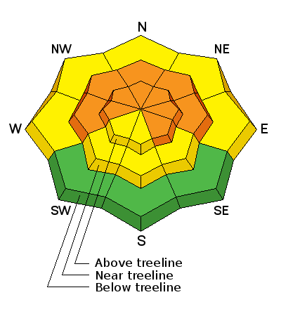
| type | aspect/elevation | characteristics |
|---|

|
|
LIKELIHOOD
 LIKELY
UNLIKELY
SIZE
 LARGE
SMALL
TREND
 INCREASING DANGER
SAME
DECREASING DANGER
|
|
description
The new snow accompanied by strong SW winds, will have formed new winds slabs 1'-2' deep along exposed, upper elevation ridge lines and on the lee sides of terrain features in exposed terrain. Look for signs of instability such as cracking or collapsing, and be alert to the smooth, rounded, pillow-like characteristics of recently deposited wind slabs. Avoid travel on or under slopes steeper than 35 degrees today, and remember that a new slab triggered may have the potential to affect buried, weaker layers triggering a larger, persistent slab.
|
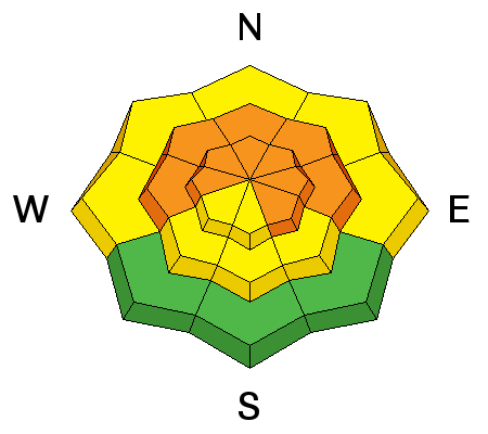
| type | aspect/elevation | characteristics |
|---|

|
|
LIKELIHOOD
LIKELY
UNLIKELY
SIZE
 LARGE
SMALL
TREND
INCREASING DANGER
SAME
DECREASING DANGER
|
|
description
The current snow pack is very weak and buried, persistent slabs still exist, primarily on steep, upper elevation slopes with NW-N-NE aspects. The additional load of new snow will begin to affect these buried weak layers, but the question is, how much load can they sustain? I suspect forecasted snow totals will bring us closer to the brink, but not quite tip the scales for a widespread avalanche cycle. Nevertheless, conditions will be ripe for a skier or snowmobile to trigger a buried persistent slab which will be large and dangerous. |
 |
weather Snow will continue through the day with another 5-9" possible. Winds will taper off and shift more to the NW averaging around 10 mph. High temperatures will be in the mid 20's. Snow showers will linger overnight, with things drying out a bit on Saturday. |
| general announcements OBSERVATIONS: If you are out and about in the mountains, I'd love to know what you are seeing so please SUBMIT OBSERVATIONS You can read current OBSERVATIONS HERE. LUNA GROOMING INFORMATION: Grooming has been cancelled for today. ROAD CONDITIONS: The road will not be plowed and travelers will be left to their own devices. UAC MOBILE APP: Get your advisory on your iphone with this app
|


_2.jpg)
