
| During the month of April, Mark Miller will donate $75 to the charity of your choice (5 to chose from, including the Utah Avalanche Center!) Mark Miller Subaru has raised over $300k in the previous 6 Do Good Feel Good events. More Info here |  |
| During the month of April, Mark Miller will donate $75 to the charity of your choice (5 to chose from, including the Utah Avalanche Center!) Mark Miller Subaru has raised over $300k in the previous 6 Do Good Feel Good events. More Info here | |
| Advisory: Moab Area Mountains | Issued by Eric Trenbeath for Tuesday - January 28, 2014 - 6:41am |
|---|

|
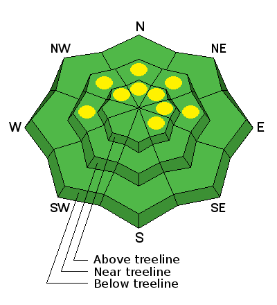
bottom line The avalanche danger is generally LOW at this time. Low danger doesn't mean no danger, and you still need to be alert to unstable snow on isolated terrain features. With snow forecasted for later this week, and with winds on the increase, expect this danger to rise. There are isolated pockets of MODERATE danger where it is possible to trigger a loose, faceted snow avalanche, primarily on very steep, shady terrain where the entire snow pack consists of weak, sugary snow. There also remains a very isolated MODERATE danger for triggering a buried persistent slab, or wind slab, primarily on upper elevation terrain, steeper than about 40 degrees that faces the north half of the compass.
|
 |
current conditions
La Sal Mountains Winds have begun to howl from the WNW, blowing in the 30-40 mph range along ridge tops with gusting to 50 mph. Temperatures have plummeted and it is currently 12 degrees at 10,000'. The snow surface remains an extremely mixed bag with a variety of hard and breakable wind and sun crusts in exposed areas. Some of the wind crusts are breaking down and it is possible to find soft, re-crystallized snow up there. On shady aspects below tree line, faceted grains, or sugar snow have taken over most of the pack. There is currently 35" on the ground in Gold Basin, and 21" at the Geyser Pass Trailhead. Winds and Temperature on Pre-Laurel Peak (11,705') Temperature and new snow totals in Gold Basin (10,050') Total snow depth and temperature near Geyser Pass Trailhead (9850') Abajo Mountains Camp Jackson continues to report 19" on the ground at 9000'. Low snow conditions with weak, faceted snow prevail. Many sun exposed slopes showing bare ground. Winds and temperature on Abajo Peak (11,330') Snow totals at Camp Jackson (8968') |
| type | aspect/elevation | characteristics |
|---|

|
|
LIKELIHOOD
 LIKELY
UNLIKELY
SIZE
 LARGE
SMALL
TREND
 INCREASING DANGER
SAME
DECREASING DANGER
|
|
description
As the faceting process takes over the snow pack, there are areas where it is possible to trigger a loose, faceted snow avalanche. This danger exists primarily on steep, shady, sheltered slopes at mid to upper mid elevations.You can recognize these areas where the snow is unsupportable, or barely supportable for a skier or snowmobile, and where you can stick your ski pole right through to the ground. Though not large, these loose snow avalanches can sweep you of your feet, slamming you into trees or carrying you over a rock band.
|
| type | aspect/elevation | characteristics |
|---|

|

|
LIKELIHOOD
LIKELY
UNLIKELY
SIZE
 LARGE
SMALL
TREND
 INCREASING DANGER
SAME
DECREASING DANGER
|
|
description
The snow pack is currently very weak, and in many cases, complex, with a variety of weak faceted layers, crust/facet combinations, as well as depth hoar. The foundation for new snow is terrible, and with snow in the forecast later this week, we will have to be extremely vigilant. Expect the danger to rise dramatically if the anticipated series of storms produces significant snowfall. Persistent slabs themselves are deteriorating, but they can still be found, primarily on upper elevation terrain facing the north half of the compass. Spatial variability is the key phrase here with a a wide range of varying snow depths, particularly in exposed, upper elevations. Persistent north winds have scoured typical starting zones, so areas to suspect are further down slope than usual. This danger is very isolated, and persistent slabs would be difficult to difficult trigger, nevertheless, they would be fairly large and dangerous. |
| type | aspect/elevation | characteristics |
|---|

|

|
LIKELIHOOD
LIKELY
UNLIKELY
SIZE
LARGE
SMALL
TREND
 INCREASING DANGER
SAME
DECREASING DANGER
|
|
description
With strong NW winds blowing along the ridge tops, we may begin to see isolated wind slabs forming on the lee sides of terrain features at upper elevations, primarily on slopes with a NE-SE aspect, There isn't much snow available for transport at this time, but expect this danger to rise significantly as it begins to snow later this week.
|
 |
weather A change in the weather pattern is finally coming as a moist, Pacific storm system is poised to move across the region, and today should be the last day for sunny skies. High temperatures at 10,000' will be near 30 degrees. Below tree line, winds will be light from the NW, but will increase dramatically at upper elevations. The storm should begin affecting our area by Wednesday afternoon with the best chance of snow occurring Thursday into Friday. |
| general announcements OBSERVATIONS: If you are out and about in the mountains, I'd love to know what you are seeing so please SUBMIT OBSERVATIONS You can read current OBSERVATIONS HERE. LUNA GROOMING INFORMATION: Grooming is scheduled for Mondays and Fridays. Skating and cross-country skiing conditions remain excellent. ROAD CONDITIONS: The road is clear. UAC MOBILE APP: Get your advisory on your iphone with this app
|


_2.jpg)
