| During the month of April, Mark Miller will donate $75 to the charity of your choice (5 to chose from, including the Utah Avalanche Center!) Mark Miller Subaru has raised over $300k in the previous 6 Do Good Feel Good events. More Info here |  |
| During the month of April, Mark Miller will donate $75 to the charity of your choice (5 to chose from, including the Utah Avalanche Center!) Mark Miller Subaru has raised over $300k in the previous 6 Do Good Feel Good events. More Info here | |
| Advisory: Moab Area Mountains | Issued by Eric Trenbeath for Sunday - January 5, 2014 - 6:50am |
|---|


|
bottom line A MODERATE avalanche danger still exists though the problem is becoming more isolated. Buried, persistent slabs overlying weak, sugary snow, remain the prime area of concern. Though this problem is becoming more isolated, it still exists on upper mid elevation slopes steeper than about 35 degrees that have a NW-NE aspect. Suspect smooth, rounded areas down slope from ridge tops and beneath rock bands. There is also a MODERATE danger of triggering a loose snow avalanche on steep shady slopes, primarily at mid elevations, where the snow pack has been taken over by the faceting process. Elsewhere in the range, the avalanche danger is generally LOW.
|
 |
current conditions Saturday's weather can best be described as all huff and puff and no fluff. Cold NW winds blew most of the day averaging 20 mph with gusts near 40.Trace amounts of snow fell but I think it all ended up out in the desert near Shiprock. Winds tapered off for a few hours overnight, but have come back in earnest, blowing in the 25-40 mph range from the WNW. Overnight low temperatures have been frigid, and it is currently -4 degrees at 10'000'. La Sal Mountains Wind, sun, and cold, clear nights have taken their toll on snow pack and surface conditions are extremely variable out there right now. Breakable, and supportable sun crusts can be found on sunny exposures, and wind crusts abound on exposed shadier aspects. Soft, settled, re-crystallized powder conditions can still be found in the most sheltered areas. Much of the pack is being taken over by facets, which means that it is turning into a pile of sugar, particularly on sheltered, mid-elevation slopes, In these areas, it is possible to sink right through to the ground. There is currently 21" on the ground at Geyser Pass Trailhead, and 33" in Gold Basin, but "spatial variability" best describes the distribution of snow throughout the range. Some wind and sun exposed areas show bare ground. Exposed ridge tops with northerly aspects have been scoured by northerly winds, but just down slope 100' or less, up to 4' of snow can be found. On sheltered, mid elevation slopes, average snow depth is 24-30". Abajo Mountains Low snow conditions prevail in the Abajos. Snow depths range from about 18"-24" of snow above about 10,000' on shady aspects. Bare ground is exposed on south facing slopes, and even east facing slopes with a slight southerly component are showing areas of exposed ground. Snow surface conditions are similar to those in the La Sals. The Snotel site at Camp Jackson is reporting 19" on the ground. |
 |
recent activity . |
| type | aspect/elevation | characteristics |
|---|

|
|
LIKELIHOOD
 LIKELY
UNLIKELY
SIZE
 LARGE
SMALL
TREND
 INCREASING DANGER
SAME
DECREASING DANGER
|
|
description
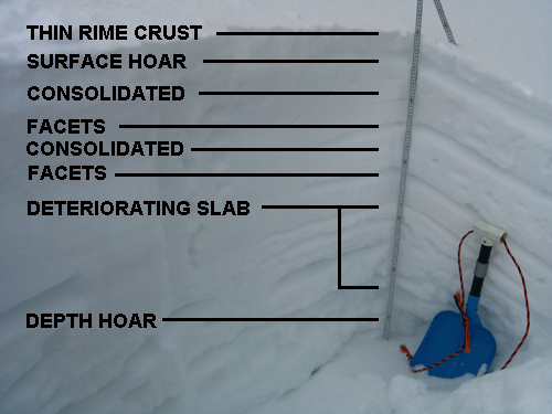
It still may be possible to trigger a buried persistent slab though this danger is quite isolated. You are most likely to find these slabs on upper-mid elevation, NW-NE aspects steeper than 35 degrees, particularly in areas of rocky terrain. Because many of the ridge tops have been wind scoured, expect to find this problem further down slope. You will need to be alert to areas that have a smooth, rounded appearance. Be cautious of convexities, and watch out for isolated pockets on the lee sides of terrain features, and beneath rock bands. Of greater concern for the future is our existing snow pack. it consists of a variety of weak layers including buried surface hoar, depth hoar, facet/crust combinations, and areas where the entire pack has turned to faceted, sugary snow. This type of snow pack structure does not bode well for the future, and we are now playing a waiting game in anticipation of the next snow load.This snow pit from the top of Coyote Chute illustrates what we are dealing with.
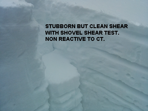
Shears were found in the upper, buried surface hoar layer, and on a mid pack facet layer with a shovel shear test. A compression test produced a relatively stubborn failure of the entire pack on the buried depth hoar, CT14 Q3.
|
| type | aspect/elevation | characteristics |
|---|

|

|
LIKELIHOOD
 LIKELY
UNLIKELY
SIZE
 LARGE
SMALL
TREND
INCREASING DANGER
SAME
DECREASING DANGER
|
|
description
Much of the snow pack is turning into a pile of facets, or loose, weak, non-cohesive snow. This snow can sluff off as a pile of sand, entraining more snow as it goes. And though it most likely won't bury you, it can sweep you off your feet, carry you over a rock band, or onto a buried, persistent slab. This problem is most prevalent on steep shady slopes at upper mid elevations. |
 |
weather It is going to be a cold, breezy, but sunny day in the mountains. High temperatures at 10,000' will be around 15 degrees, with moderate NW winds making it feel like -15. Tonight will be clear with lows in the single digits. Monday looks to be sunny with temperatures rising back up into the high 20's. Disagreeing models forecast another split system later in the week, with one signifying the end of the dry NW flow. But either way, we have little on the horizon for more snow. |
| general announcements OBSERVATIONS: If you are out and about in the mountains, I'd love to know what you are seeing. Please submit your OBSERVATIONS HERE LUNA GROOMING INFORMATION: All trails including the upper meadows at Geyser Pass and the road into Gold Basin are groomed and in excellent shape. ROAD CONDITIONS: The road is clear with a mixture of bare dirt, and a packed surface of snow. UAC MOBILE APP: Get your advisory on your iphone with this app
|


_2.jpg)