
| During the month of April, Mark Miller will donate $75 to the charity of your choice (5 to chose from, including the Utah Avalanche Center!) Mark Miller Subaru has raised over $300k in the previous 6 Do Good Feel Good events. More Info here |  |
| During the month of April, Mark Miller will donate $75 to the charity of your choice (5 to chose from, including the Utah Avalanche Center!) Mark Miller Subaru has raised over $300k in the previous 6 Do Good Feel Good events. More Info here | |
| Advisory: Moab Area Mountains | Issued by Eric Trenbeath for Friday - December 20, 2013 - 6:59am |
|---|

|
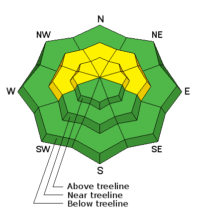
bottom line There is currently a LEVEL 2 (MODERATE) avalance danger at this time. Buried, persistent slabs overlying weak, sugary snow, remain the prime area of concern. Though continually lessening, this problem still exists on mid to upper elevation slopes steeper than about 35 degrees that have a NW-NE aspect. The second danger is recently deposited wind slabs from the strong SSW winds that blew up high yesterday. This danger is likely isolated, and will present itself on upper elevation N-NE aspects, Elsewhere, the avalanche danger is generally LOW.
|
 |
special announcement . |
 |
current conditions My foray over to Cork Screw Glades yesterday made one thing painfully clear, we need more snow! Once you got there, skiing was actually quite good on settled, re-crystallized powder with about a 20" base at the bottom of the glades, and close to 30" at the top. But the trek over and back bordered on unmanageable with low snow, a mixed bag of surface conditions, and exposed ground on southerly aspects. Higher up in the range, there is still plenty of snow to slide around on but boy do we sure need a refresher. in addition, the snowpack is growing weaker and weaker as the faceting process is beginning to take over the entire snowpack on shady aspects. What this means is that the snowpack is turning into a weak pile of sugar, which won't hold up well when we finally get another load of snow on top. A split system has largely moved on giving the Wasatch to the north a much needed shot of new snow, while the southern portion of the storm has dipped far south of us. Instrumentation in Gold Basin is reporting a couple inches of new snow with only a trace at the Geyser Pass Trailhead. Winds yesterday whipped up high, blowing in the 30's and gusting to 50 out of the south. Overnight, they dropped into the 20's, and are now currently averaging about 10 mph from the WSW. Expect cloudy skies and light snow showers early in the day today, with perhaps an inch or two of new snow possible. High temperatures will be in the upper twenties. |
 |
recent activity . |
| type | aspect/elevation | characteristics |
|---|

|

|
LIKELIHOOD
 LIKELY
UNLIKELY
SIZE
 LARGE
SMALL
TREND
 INCREASING DANGER
SAME
DECREASING DANGER
|
|
description
Buried, persistent slabs continue to be the main area of concern though the odds of triggering one of these slabs are growing less likely. However, very weak, faceted, sugary snow snow still underlies them and a slide triggered under these conditions would be large and dangerous. Continue to avoid steep, northerly facing, upper elevation terrain. Be particularly leery of rocky terrain and areas beneath cliff bands. Suspect areas with a smooth, rounded appearance, and be alert to the many steep convexities in our mountain range. This type of terrain can lure you far down a slope to where if a slide is released, it will fracture well above you. |
| type | aspect/elevation | characteristics |
|---|

|
|
LIKELIHOOD
LIKELY
UNLIKELY
SIZE
 LARGE
SMALL
TREND
 INCREASING DANGER
SAME
DECREASING DANGER
|
|
description
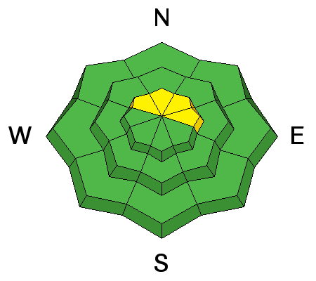
Without loose snow available for transport on southerly aspects, the strong, SW winds shouldn't have had much to work with. Nevertheless, any available snow will have been picked up and deposited elsewhere. Be alert to pockets of recently deposited, wind drifted snow on upper elevation, NW-E aspects along ridge crests and on the lee sides of terrain features. |
 |
weather Snow showers should linger through the morning with perhaps an inch or two of snow possible. Winds will be light out of the SW and temperatures at 10,000 feet will be in the mid 20's. Continued light winds will shift around to the NW this evening as a short wave disturbance moves across our area bringing with it another chance of snow for Saturday. 2"-4" are possible, By Sunday, things again begin to dry out with mostly sunny skies lined up for early next week. For the most up to date wind and temperature conditions, go to our automated weather station at 11,600' on Pre Laurel Peak click here: http://mesowest.utah.edu/cgi-bin/droman/meso_base.cgi?stn=lsl For new snow totals in Gold Basin click here: http://mesowest.utah.edu/cgi-bin/droman/meso_base.cgi?stn=goldb |
| general announcements OBSERVATIONS: If you are out and about in the mountains, I'd love to know what you are seeing. Please submit your observations here: http://utahavalanchecenter.org/bc_obs_1 To view observations posted by others, go here: http://utahavalanchecenter.org/observations/moab LUNA GROOMING INFORMATION: Thanks to all who came to the grooming training yesterday! Grooming has begun, and with this weather pattern, skating and cross country skiing may be the sport of choice. ROAD CONDITIONS: Plow crews will be initiating road closures during plowing this season due to conflicts with traffic. The plan is to call me the day before they plan to plow so I can post it in this advisory. This closure could take up to two hours so please plan accordingly. Do not expect plowing over the weekend. San Juan County does an excellent job keeping our road open but please keep in mind that their first priority after a storm is to open roads in and around populated areas. UAC MOBILE APP: Get your advisory on your iphone here: https://itunes.apple.com/us/app/utah-avalanche-center/id605579982?mt=8
|


_2.jpg)