| During the month of April, Mark Miller will donate $75 to the charity of your choice (5 to chose from, including the Utah Avalanche Center!) Mark Miller Subaru has raised over $300k in the previous 6 Do Good Feel Good events. More Info here |  |

For every car Mark MIller Subaru sells in April, they will donate $75 to the charity of your choice (5 to choose from). Who are you going to choose? Plus - you can vote for your favorite and the 3 groups receiving the most votes get an additional cash prize donated by Mark Miller Subaru. Details here

| During the month of April, Mark Miller will donate $75 to the charity of your choice (5 to chose from, including the Utah Avalanche Center!) Mark Miller Subaru has raised over $300k in the previous 6 Do Good Feel Good events. More Info here |  |
| Advisory: Moab Area Mountains | Issued by Eric Trenbeath for Sunday - December 15, 2013 - 6:31am |
|---|
 |
current conditions Saturday was another balmy day in the mountains with clear skies and warm temperatures in the upper 20's at 10,000'. A mixed bag of surface conditions exists including a variety of sun and wind crusts. Winds picked up last night around 10:00 p.m. and have been averaging 20 mph with gusts to 40 out of the NNW. This will undoubtedly have an effect on the remaining powder in upper elevation areas. Best bet now for settled powder conditions will be on northerly aspects below tree line. The temperature is currently 20 degrees on Pre Laurel Peak, and it will climb to near 30 today. There is currently 21" on the ground at Geyser Pass Trailhead, and 35" in Gold Basin. |
 |
recent activity . |
| type | aspect/elevation | characteristics |
|---|


|


|

LIKELIHOOD
 LIKELY
UNLIKELY
SIZE
 LARGE
SMALL
TREND
 INCREASING DANGER
SAME
DECREASING DANGER
|
|
description
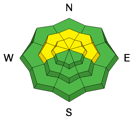
My own findings as well as observations from others indicate that the winds slabs formed during last weekend's storm have gained strength and are now bonded well to the existing snow pack. Buried, persistent slabs remain the main areas of concern. Warmer temperatures over the past week have helped to strengthen these slabs, and though the odds of triggering them are growing less likely, weak faceted snow still underlies them. Overall, it's not a great recipe, and a slide triggered under these conditions wold be large and dangerous. Continue to avoid steep, north facing, upper elevation terrain. Be particularly leery of rocky terrain and areas beneath cliff bands. Suspect areas with a smooth, rounded appearance, and be alert to the many steep, convexities in our mountain range. This type of terrain can lure you far down a slope to where if a slide is released, it will fracture well above you. |
| type | aspect/elevation | characteristics |
|---|


|


|

LIKELIHOOD
 LIKELY
UNLIKELY
SIZE
 LARGE
SMALL
TREND
 INCREASING DANGER
SAME
DECREASING DANGER
|
|
description
The strong, gusty, NW winds, will have blown available snow around at the upper elevations creating new, isolated wind slabs along ridge crests primarily on slopes with E-SE-SW aspects. Also be alert for cross loading on upper elevation, northerly aspects on the lee sides of terrain features. Look for characteristic, rounded pillows indicating recent deposits of wind drifted snow. |
 |
weather Sunny skies and steadily warming temperatures are in line for the next few days as we remain under a dry, northwest flow. Daytime highs will approach 30 degrees and the winds will back off to around 5 mph from the SW. A spilt trough and strengthening SW flow will move into our area Thursday, bringing with it our next chance at snow. Confidence in significant amounts isn't high at this time. |
| general announcements OBSERVATIONS: If you are out and about in the mountains, I'd love to know what you are seeing. Please submit your observations here: http://utahavalanchecenter.org/bc_obs_1 To view observations posted by others, go here: http://utahavalanchecenter.org/observations/moab LUNA GROOMING INFORMATION: Thanks to all who came to the grooming training yesterday! Grooming has begun, and with this weather pattern, skating and cross country skiing may be the sport of choice. ROAD CONDITIONS: Plow crews will be initiating road closures during plowing this season due to conflicts with traffic. The plan is to call me the day before they plan to plow so I can post it in this advisory. This closure could take up to two hours so please plan accordingly. Do not expect plowing over the weekend. San Juan County does an excellent job keeping our road open but please keep in mind that their first priority after a storm is to open roads in and around populated areas. UAC MOBILE APP: Get your advisory on your iphone here: https://itunes.apple.com/us/app/utah-avalanche-center/id605579982?mt=8
|
Advisory Hotline: (888) 999-4019 | Contact Information