
| During the month of April, Mark Miller will donate $75 to the charity of your choice (5 to chose from, including the Utah Avalanche Center!) Mark Miller Subaru has raised over $300k in the previous 6 Do Good Feel Good events. More Info here |  |
| During the month of April, Mark Miller will donate $75 to the charity of your choice (5 to chose from, including the Utah Avalanche Center!) Mark Miller Subaru has raised over $300k in the previous 6 Do Good Feel Good events. More Info here | |
| Advisory: Moab Area Mountains | Issued by Eric Trenbeath for Monday - December 9, 2013 - 6:40am |
|---|

|
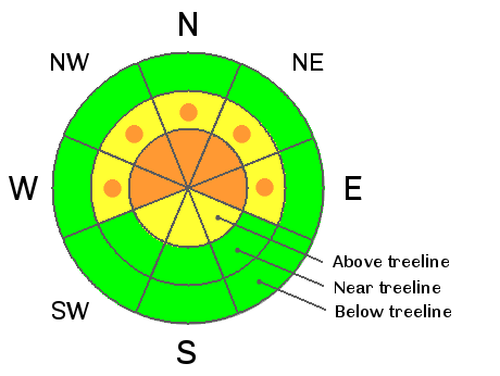
bottom line At upper elevations there still remain areas of CONSIDERABLE danger on slopes steeper than 35 degrees with a NE-NW aspect. This danger is most prevalent along ridge crests, near rock bands, and on the lee sides of terrain features where wind slabs have formed form the weekend storm. There is also the potential to trigger a deep, persistent slab in these areas. There is a MODERATE danger of triggering an avalanche this time on slopes steeper than 35 degrees with a NE-NW aspect at mid elevations. Remember that MODERATE danger means that human triggered avalanches are possible.
|
 |
special announcement The following report is based on conditions observed in the field on Sunday, December 8, and weather data gathered on Monday, December 9, at 6:00 a.m. The report will describe snow, avalanche, and weather conditions observed at that time, and is meant to provide a baseline for the coming week. Should significant changes occur, this report will be updated. |
 |
current conditions Well it's always good to get out in the field and either confirm or deny your forecast. I read Sunday's snow totals of only 4" with some skepticism. Skepticism that grew when I found 6"-8" on the Geyser Pass Road. As it turns out, snow fall totals varied wildly for the La Sal Mountains from this storm. Storm boards at Geyser Pass Trailhead and Gold Basin did reveal 4" and 6" respectively. I found 8"-10" at higher elevations with areas of wind deposited snow up to a foot deep. Then came this whopping report from Karl Kelley, with pictures, from the South Mountain area where he reported 20" of new snow! http://utahavalanchecenter.org/observations/18938 Powder conditions are excellent below tree line but expect to find wind affected snow above, particularly on westerly aspects. There is currently 21" on the ground at the Geyser Pass Trailhead, 40" in Gold Basin, and 28" at Camp Jackson. |
 |
recent activity In my travels on Sunday, I observed several recent avalanches. These were all confined to the new snow, consisting of recently deposited wind slabs on upper elevation slopes near ridge crests. They were on slopes with NW-NE aspects, about 40 degrees in steepness, and close to 12,000 feet. For details, see our list of avalanches here: http://utahavalanchecenter.org/avalanches/list/moab |
| type | aspect/elevation | characteristics |
|---|

|

|
LIKELIHOOD
 LIKELY
UNLIKELY
SIZE
 LARGE
SMALL
TREND
 INCREASING DANGER
SAME
DECREASING DANGER
|
|
description
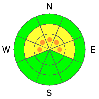
Wind slabs created during the weekend storm cycle will remain sensitive to the weight of a skier or rider for the next couple of days. They will gain strength over the course of the week as warmer temperatures slowly set in, nevertheless, given the consequences, and with the potential for one of these slabs to step down deeper into the buried persistent slab, I would continue to avoid these areas. These new wind slabs can mostly be found on steep, exposed terrain near ridge crests on slopes that have a NE-NW aspect. Pay attention to areas in and around rock bands and on the lee sides of terrain features at upper elevations. |
| type | aspect/elevation | characteristics |
|---|

|
|
LIKELIHOOD
 LIKELY
UNLIKELY
SIZE
 LARGE
SMALL
TREND
 INCREASING DANGER
SAME
DECREASING DANGER
|
|
description
Persistent slabs remain over-riding buried weak snow. This problem exists on mid to upper elevation slopes with NW-NE aspects where snow has remained on the ground since early October. Newly deposited dense wind slabs have increased the load on this deeper instability adding more straw to the proverbial camels back. The added weight of a skier or rider could be just enough to tip the scales triggering a large and very dangerous avalanche. |
 |
weather Conditions look to be high and dry for the upcoming week, with a general warming trend in the mountains. Monday looks to be the last of the bitter cold with high temperatures remaining in the single digits. By Tuesday, temps warm into the low 20's and up to around 30 by midweek. I got the Pre Laurel weather station up and running on Sunday, and you can check it here for the latest winds and temperatures at 11,700' http://mesowest.utah.edu/cgi-bin/droman/meso_base.cgi?stn=lsl The Gold Basin study plot is also up and running and you can check it for new snow totals and temperatures http://mesowest.utah.edu/cgi-bin/droman/meso_base.cgi?stn=goldb |
| general announcements LUNA Information: There will be a meeting for all interested grooming volunteers next Saturday, December 14, at 8 a.m. at the MARC. ROAD CONDITIONS: Plow crews will be initiating road closures during plowing this season due to conflicts with traffic. The plan is to call me the day before they plan to plow so I can post it in this advisory. This closure could take up to two hours so please plan accordingly. San Juan County does an excellent job keeping our road open but please keep in mind that their first priority after a storm is to open roads in and around populated areas.
|


_2.jpg)
