
| During the month of April, Mark Miller will donate $75 to the charity of your choice (5 to chose from, including the Utah Avalanche Center!) Mark Miller Subaru has raised over $300k in the previous 6 Do Good Feel Good events. More Info here |  |
| During the month of April, Mark Miller will donate $75 to the charity of your choice (5 to chose from, including the Utah Avalanche Center!) Mark Miller Subaru has raised over $300k in the previous 6 Do Good Feel Good events. More Info here | |
| Advisory: Moab Area Mountains | Issued by Eric Trenbeath for Sunday - December 8, 2013 - 6:43am |
|---|

|
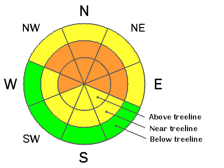
bottom line The bottom line is a CONSIDERABLE avalanche danger on slopes steeper than 35 degrees that have recent deposits of wind drifted snow. Look for signs of cracking and characteristic, smooth, rounded pillows of recently deposited snow. Pay particular attention to the lee sides of terrain features and along ridge crests. This danger is most pronounced on slopes with a NW-NE aspect at mid to upper elevations. Considerable danger means natural avalanches are possible and human triggered avalanches are likely, so choose slopes carefully, practice safe travel techniques, and stay out from under run out zones.
|
 |
current conditions The main energy from this storm has passed leaving the La Sal Mountains with only about 4" of new snow in spite of all the fanfare. The Abajo Mountains to the south picked up close to a foot of new snow, and the Skyline to our north picked up 12"-15". Somehow, we got left out in the middle. Showers will linger through the morning. Today will be bitter cold with wind chill values at around -10. The wind turns out to be the major player in this story and it will have left its mark on the snow surface. Expect to find thick, slab-like conditions and wind affected snow in exposed areas. Best bet for soft powder will be in sheltered areas below tree line. There is currently 21" on the ground at the Geyser Pass Trailhead, 40" in Gold Basin, and 28" at Camp Jackson. |
 |
recent activity . |
| type | aspect/elevation | characteristics |
|---|

|
|
LIKELIHOOD
 LIKELY
UNLIKELY
SIZE
 LARGE
SMALL
TREND
 INCREASING DANGER
SAME
DECREASING DANGER
|
|
description
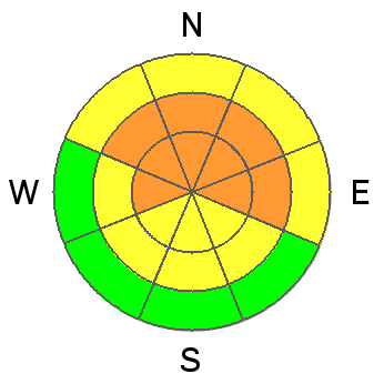
In spite of relatively low new snow totals, there was still plenty of snow available for transport, and yesterday in the mountains I observed lots of it blowing around. New wind slabs were forming along ridge crests and in exposed terrain on the lee sides of terrain features and they will be sensitive to the weight of a skier or rider. The hazard will be most pronounced on slopes steeper than about 35 degrees that have a NW-E aspect at mid and upper elevations. Be alert to signs of instability in the snow such as cracking or collapsing, and look for characteristic, round, smooth pillows that indicate recently deposited wind slabs. |
| type | aspect/elevation | characteristics |
|---|

|
|
LIKELIHOOD
LIKELY
UNLIKELY
SIZE
 LARGE
SMALL
TREND
INCREASING DANGER
SAME
DECREASING DANGER
|
|
description
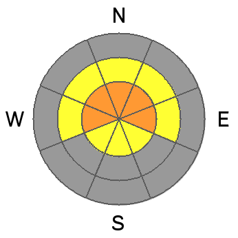
The second avalanche problem continues to be persistent slabs over-riding buried weak snow. This problem exists on mid to upper elevation slopes with NW-NE aspects where snow has remained on the ground since early October. Newly deposited dense wind slabs have increased the load on this deeper instability adding more straw to the proverbial camels back. The added weight of a skier or rider could be just enough to tip the scales triggering a large and very dangerous avalanche. |
 |
weather Showers should linger through the morning. Temperatures will again be biter cold, around 10 degrees for a high with wind chill values at -10. Winds will back off and become light out of the west at around 10 mph. Look for things to dry out with a return to warmer temperatures this week. |
| general announcements LUNA Information: There will be a meeting for all interested grooming volunteers next Saturday, December 14, at 8 a.m. at the MARC. ROAD CONDITIONS: Plow crews will be initiating road closures during plowing this season due to conflicts with traffic. The plan is to call me the day before they plan to plow so I can post it in this advisory. This closure could take up to two hours so please plan accordingly. Do not expect plowing over the weekend. San Juan County does an excellent job keeping our road open but please keep in mind that their first priority after a storm is to open roads in and around populated areas.
|


_2.jpg)
