SPECIAL ANNOUNCEMENT |
 |
Super groomer extraordinaire Matt Hebberd has groomed the Gold Basin track Friday! Anyone who gets it early Saturday morning is going to be psyched! |
|
|
BOTTOM LINE
Danger by aspect and elevation on slopes approaching 35° or steeper.
(click HERE for tomorrow's danger rating)
|
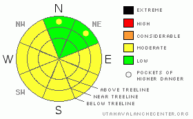
Danger Rose Tutorial
|
The Bottom Line for the weekend of March 24th will be an avalanche danger of Moderate on sunny aspects after 11 am for wet loose point releases and a potential of wet slab avalanches.
It is close to being hot out. Start early from the trail head. A 6:30 start time for a peak and a East or Southerly aspect may be too late. |
|
|
CURRENT CONDITIONS |

|
Spring time conditions. Corn. Early starts and afternoon mountain bikes. Our tour today started from the trail head by 7:30 am. By 9:30 am, our party had to turn around on our east aspect at 11,800' to perfect corn conditions below and the beginning of unstable mash potatoes above. Spring skiing is on!
If you are venturing out this weekend, make sure temperatures dip below freezing on the SNOTELsites, a list of which is next to this forecast. Don't forget the sun screen. If your post holing through, it is time to turn around.
If the clouds roll in and the winds begin to blow, the conditions may be locked up. In this case, keep a viable option open in the red rock desert. OR... skate ski anywhere you want! |
|
|
RECENT ACTIVITY |

|
Wet point releases have been occurring from under rock outcroppings on easterly and southerly aspects. West aspects are burning off quite quickly and should not be attempted, unless the slope is well covered. Its too warm for these aspects to hang on much longer. |
|
|
THREAT #1 |

|
| WHERE |
PROBABILITY |
SIZE |
TREND |

|
|
|
|
| |
|
|
Over the next
48 hours.
|
|
|
Start early and end early! Watch for signs of instabilities such as roller balls or unsupportable wet snow. Stay clear of steep rock outcroppings. |
|
|
MOUNTAIN WEATHER |

|
@ 10,000' in Gold Basin, La Sal Mountains Utah Saturday: Mostly sunny, with a high near 54. Breezy, with a south wind between 10 and 20 mph, with gusts as high as 30 mph. Saturday Night: Mostly clear, with a low around 37. Breezy, with a south wind between 15 and 20 mph. Sunday: Sunny, with a high near 56. Windy, with a south wind between 20 and 30 mph, with gusts as high as 45 mph. Sunday Night: Partly cloudy and windy, with a low around 32. Monday: A 50 percent chance of snow showers. Some thunder is also possible. Mostly cloudy and windy, with a high near 42. Monday Night: A slight chance of snow. Partly cloudy and windy, with a low around 23. Tuesday: Sunny, with a high near 44. |
|
|
This information does not apply to developed ski areas or highways where avalanche control is normally done. This advisory is from the U.S.D.A. Forest Service, which is solely responsible for its content. This advisory describes general avalanche conditions and local variations always occur. |
|
This advisory provided by the USDA Forest Service, in partnership with:
The Friends of the Utah Avalanche Center, Utah Division of State Parks and Recreation, Utah Division of Emergency Management, Salt Lake County, Salt Lake Unified Fire Authority and the friends of the La Sal Avalanche Center. See our Sponsors Page for a complete list. |
